Thursday, February 28, 2019

February recap - Records broken

NOTE: Blog updated 315 AM Mar 2nd with final numbers for February.  LaCrosse was missing data from Feb 27-28.
--------------------------------------------------------------------------------------------------------------------------

What a month it has been!  In this blog will highlight some of the top events of the month and look at how the month finished by the numbers.  Hint - several snow records broken.

Feb 9th Blizzard

Strong winds and snow brought blowing and drifting snow to much of the region.  This was especially true on the Waterville Plateau and Moses Lake area where blizzard conditions brought scenes like this on Highway 2 east of Waterville.

Highway 2 east of Waterville - Photo courtesy of WADOT

Road closures were numerous, with a lot of this going on to get the roads back open.

State Route 27 near Colfax - Photo courtesy of WSDOT

Late Feb 11-Feb 12 Bonners Ferry breaks 2 day snow record

A sharp frontal boundary over Bonners Ferry, Idaho resulted in a band of very heavy snowfall.  This brought a record 2 day snowfall as noted below with 24.7".  These are morning 24 hour observations and thus the combined total is from the Feb 12th and 13th reports.


Feb 25-27th Columbia Basin and Palouse snow/drifting snow

Despite being so late in the month, more rounds of snow moved in.  The snow remained of the powder variety making it very susceptible to drifting as the winds picked up.  Several road closures occurred as snow drifts reached 12 feet high in spots which made it a challenge to open roads like the picture below shows.  Yes, that's a stop sign in the picture.  
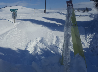
State Route 27 - Photo courtesy of WSDOT 

 February by the numbers

Snow


 Let's begin with snow.  Several sites finished in the top 5 list of total snowfall as shown below.


Total snowfall broke a record at Lewiston, La Crosse, Rosalia, Wenatchee, Lind, and Saint Maries.  Spokane and Coeur d'Alene finished in 2nd place.  Note for some locations we are awaiting numbers for the last few days of the month so the results above are not final.

How about number of days of February snow?  Many records broken here as well.


How about the amount of snow on the ground for February 28th?  Surprisingly while the snow is deep in many spots, records for the date were hard to find.  However, Lewiston and Spokane made the list.  Lewiston smashed its previous record.


Note for Spokane we have about the same amount of snow on the ground now as we had on February 28th, 1969.  Note the snow depth for this day in 1969 was missing, but showed 17" the day before and 16" the day after.

Now there was one part of our region where total snow this month wasn't a big deal.  Where you ask?  Parts of North Central Washington including Omak and Winthrop finished drier than normal in terms of precipitation amounts.


Yet one last record related to precipitation to mention here.  Again for Lewiston where 3.42" of total precipitation has fallen for the month breaking the monthly February precipitation record.

Temperatures


Now how about the cold temperatures?


Note that several stations finished in the top 10, but none were coldest on record.  Again, these numbers are preliminary since we are awaiting some final numbers for the past few days for some locations. As you can see February 1936 was quite the brutally cold month across the region.

How much colder compared to normal has it been?  Here is a map below


Most places are in the blue shading (10-15F below normal).  Montana was especially in the freezer this month.


Wednesday, February 20, 2019

What is our snow load?

Are you wondering about the weight of snow on your roof?  We have received a few questions lately regarding this topic, so let's take a look.

When looking for the possibility of a roof collapsing, we want to take into consideration the different weights that snow may hold due to water content.  Light, dry snow weight ranges from 1 to 3 lb/ft² while wet, heavy snow can reach up to 21 lb/ft².  Once the snow has fallen, the snow can accumulate more liquid through humidity, and any additional rain that has fallen.  Snow tends to act like a sponge and even though it may look like the snow depth is decreasing, the snow is actually absorbing the excess water.  In other words, the depth of the snow can be misleading compared to the weight of the snow.

For most valley areas (excluding the Cascades and up near the Canadian border) there was little to no snow on the ground to start the month off.   When looking at the maps below, we can see the weight of the snow (in lbs/square foot) as worst case scenario being placed on the roofs in terms of February contributions.  This means that if there was no day time melting that occurred during the month, there could potentially be up to the stated weight on the roofs assuming no snow was on your roof to begin the month which was the case for most of these areas.  But chances are that there was daytime melting that was occurring especially given the higher February sun angle bringing the total weight down.

Snow load weight in lb/ft² - February 20th, 2019

As you can see under 20 pounds per square foot for all reports listed except for near Plummer, ID.  These values are much less than the December 2008 values that brought roof collapses to part of the region including Spokane.

Here are some suggested signs of snow load problems
  • Cracks in the walls that were not previously there or have extended
  • Frequent popping, creaking, or cracking sounds
  • The roof visibly sagging
  • Doors, windows that are noticeable harder to open or close, especially interior doors

For more information about structural snow loads, feel free to visit FEMA Snow Load Safety Guide

Monday, February 18, 2019

Two more snow events this week

The wild February continues on with more snow for the upcoming week.  Will February snow records be threatened?  When will the snow fall?  How much?  What will the impacts be? Let's get to it.

First, let's take a look at how much snow has fallen so far this February based on reports we've received through the 17th along with the February record for the entire month.


As you can see, most places still need quite a bit of snow to threaten the February record but more is coming. At this point Saint Maries, La Crosse, and Nez Perce have the best chances of breaking the record.

Here is where Spokane ranks as of February 17th with the top 10 February events listed


There is a very good chance Spokane will rise into 2nd place by the end of this week.

Now let's take a look at the week ahead.

Tuesday/Wednesday Storm

Another storm arrives Tuesday afternoon and lingers into Wednesday.  Here is one model depiction of the weather pattern.

00z/18th GFS Model forecast of 500mb heights and 700-500mb Relative Humidity valid 4 AM PST Feb 20th, 2019

This pattern sure looks familiar.  Strong high pressure off the coast with another storm dropping in from the northwest.  Note all the green shade over the region indicating high moisture content and thus the snow.

Here is the same model showing precipitation timing of the storm


Snow looks to begin Tuesday afternoon, likely impacting the Tuesday evening commute.  Now for the rest of the images.


This will be a prolonged snow event for some locations with the longest duration expected over SE Washington.   Expect impacts to the Tuesday evening and Wednesday morning commute. Here is our forecast as of Monday morning for expected snowfall totals.


Models have been pretty consistent and are in agreement with this storm so there is moderate confidence in these amounts.  As always we will continue to fine tune the forecast for this storm.  Please go to our web site here for the latest forecast for your area.

Friday/Saturday Storm

There will be a short break on Thursday before yet another system arrives.  Does the weather map look familiar?

00z/18th GFS Model forecast of 500mb heights and 700-500mb Relative Humidity valid 4 PM PST Feb 22nd, 2019

Models are coming into good agreement of more snow, but differ with the details of how long this storm remains over the region.  This storm has the potential to produce as much if not more snow as the Tuesday/Wednesday one.  Stay tuned!


Wednesday, February 13, 2019

One more shot of decent snow---followed by colder temperatures, again.

We can barely catch our breath between systems, but it looks like we will see a brief lull in the action.
 
First lets review what happened within the past 24-36 hours. Pay close attention to the totals over the northern Idaho Panhandle and northwest Montana. Those totals are not erroneous. Indeed there were quite a few locations which received anywhere from 1 to 3 feet of snow over the past 24-36 hours. 


So are these values record breaking? We aren't 100% sure until we hear from the COOP observer in Bonners Ferry, but based on the current records we suspect there is a good chance.


So this was just the latest batch of snow...on top of what we have seen so far this historically snowy February. In many locations we have seen a top-10 snowiest beginning to the month of February. In addition, Spokane is already in the top-10 for the entire month (9th place) and Coeur d'Alene is in 4th place.


If you like snow and you love snow records, the upcoming weather pattern suggests our cold and snowy pattern is very likely to continue. Our break in the winter weather is expected to tomorrow with snow returning to the Cascades in the morning and spreading across the remainder of the Inland Northwest tomorrow afternoon and evening. The threat of snow will persist into Friday. So how much snow are we expecting this time?

Snow Forecast for Thursday morning-Friday evening
 This next system won't be strong in comparison to previous systems this month, but still fairly significant for mid-February system. There is still quite a bit of uncertainty with this system but for the Spokane and Pullman area, the models seem to be backing off on snow totals. Meanwhile it looks like the Cascades (and the Panhandle Mountains) will be the hardest hit portion of the Inland Northwest. There will also be a small risk of freezing rain across portions of the Columbia Basin and into the Spokane area, but amounts should be quite light and any which falls will likely occur after light snow falls, mitigating the impacts. The graphics below show the mean snowfall expected in the area from an ensemble of hi-res weather models.

Ensemble of Hi-Res model data for Spokane area. The newest solution is the red line, while the oldest is the magenta one. Notice each model run has been backing off on snow totals. The oldest runs showed around 4 inches of snow.

Ensemble model soultion for Pullman. Again the red line is the latest version and hints at 1-2 inches whereas older runs hinted at amounts around 5 inches.


Meanwhile confidence for heavier snow looks good in Wenatchee where there has been much better model consistency.
After this system goes through we are in store for another blast of cold air from the north.  This blast will result from the buckling of the upper level jet stream which will put strong ridging over Alaska and a shot of cold air arriving from the Yukon. It is expected to arrive sometime on late Sunday or Monday.


So how cold will it get? Perhaps not as cold as the last blast, but still very cold for this time of year with temperatures almost 15-20°F colder than normal. So how cold are we talking?
Here are the highs for next Monday.

Monday high temperature forecast.

Tuesday morning low temperature forecast


And the cold weather is likely to continue through most of next week. Below is the temperature forecast from the GEFS ensemble members. Notice nothing above freezing is expected.

Temperature for the Spokane area forecast by GEFS ensemble data. Suffice it to say the next couple days will be the warmest  in the area, followed by a week of cold. The thick black line is the mean forecasts while the other grey lines show all the ensemble forecasts.

With cold temperatures returning to the region any future systems we see after the weekend will undoubtedly deliver snow. How much is uncertain and there are no strong ones expected as of now but that is always subject to change. So when will this cold weather ease and return some normal or warmer than normal conditions to the region? Not anytime soon. Here is the 8-14 day outlook.


8-14 day outlook issued 2/12/19


Perhaps there is some hope after that however as model guidance from the end of February through the 1st week in March is hinting at ridging setting up off the coast and bringing us more west or southwest flow vs. the persistent northerly flow we've been seeing most of month. This is very subject to change, but at least there is a glimmer of hope for those with hopes of golfing and enjoying other springtime activities. Just don't hold it against us if this doesn't pan out accordingly.

CFS forecast for 2/26-3/5


Tuesday, February 12, 2019

Snowy February - what's next?

After such a mild winter, February has sure brought a dramatic change with round after round of snow.  In this blog we will look ahead for the rest of this week including an update on the current storm, and a look at the Thursday/Friday storm.

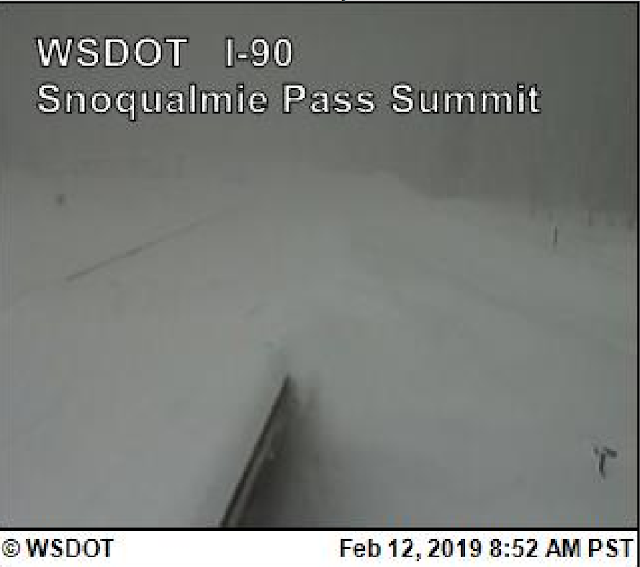
The snow totals from this storm have been incredible in the Cascades with around 50" of snow reported at Snoqualmie Pass over the past two days.  I-90 was closed as of this writing and here is the web cam from 9 am this morning.


Stevens Pass was also closed as of this writing, with a web cam at Coles Corner proof of this.


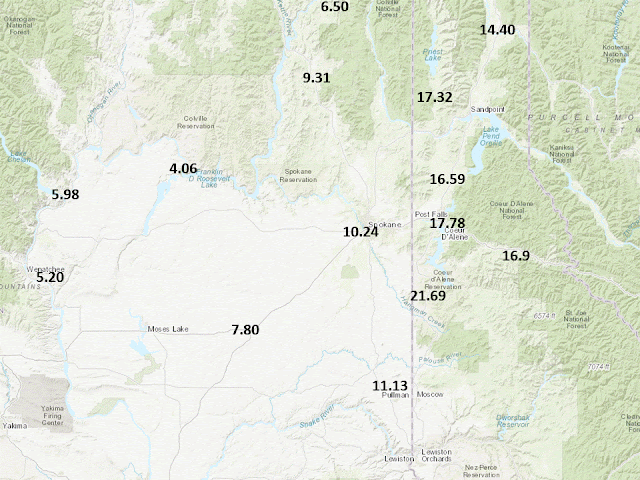
Heavy snow has also been falling around the Priest Lake area along with many areas of NE Washington into the Idaho Panhandle.  Bonners Ferry has also been hard hit with amounts in excess of 15".  We received a spotter report near this area of 23"from 10 PM Monday - 2 PM Tuesday with a location 7 miles northwest of Moyie Springs .  Here is an image from Priest Lake.


Here is a map of the heavy snow reports we have received through this afternoon over this area.

Snowfall reports received since this morning over NE Washington and North Idaho

Over southeast Washington, temperatures have warmed as predicted into the mid and upper 30s with a mild 43F in Lewiston.   But now comes the second part of the storm as a cold front sags into the region and stalls over SE Washington overnight into Wednesday morning.  Pullman/Moscow areas should receive significant snowfall.  Here are the additional snowfall amounts forecast 4 PM Tuesday to 4 PM Wednesday.

NWS Forecast of additional snowfall 4 PM Tuesday - 4 PM Wednesday

Note the lower snow amounts for the Lewiston-Clarkston area as rain or rain/snow mix will be the predominant precipitation type below 1500 feet.

Snow will impact the Wednesday morning commute for most locations from Moses Lake to Sandpoint and points south with the HRRR model shown here at 4 am showing snow falling over much of the region.

HRRR model forecast valid 4 AM PST Wednesday, February 13th, 2019

But we aren't done with the snow after this storm with another one on its heels.  Here is a satellite image from late this morning.


Here is our preliminary snowfall forecast for snow amounts with this storm.  This one will have some warmer air initially over the palouse and this could also impact snow amounts from Ritzville up through the Spokane/Coeur d'Alene area.  Localized freezing rain can also not be ruled out.  So this region carries lower confidence.

Preliminary NWS snowfall forecast valid 10 AM Thursday, February 14th - 4 PM Friday, February 15th

This storm will feature a surface low tracking up across Eastern Washington.  If this track holds areas north and west of the low center would be on the cold and snowy side of the low.

Here is the GFS model showing the low track into the region late on Valentine's Day (Thursday).  The green indicates high moisture content.

4 PM Thursday (low over Central OR)

12z GFS forecast of MSLP and 700-500mb Relative Humidity (image) valid 4 PM Thursday, February 14th, 2019

7 PM Thursday (low over SE WA)

12z GFS forecast of MSLP and 700-500mb Relative Humidity (image) valid 7 PM Thursday, February 14th, 2019

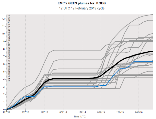
The exact track of the low will be critical for nailing down the snow amounts.  To get an idea of the uncertainty, here is a model ensemble forecast of snow amounts going into Friday.  First we will start with Spokane, then Ephrata.  The black line is the average of all the members while the blue line is the high resolution operational run of the GFS model.


For Spokane, you see some snow tonight (around 2" between 00z-12z 13th), a dry period, and then more snow on the 14th and 15th but a big range in amounts indicating high uncertainty.
  
For Ephrata, the higher resolution GFS should be correct for tonight compared to its other low resolution members with the "snow shadow" off the Cascades limiting amounts.  But then you see a big jump from the Thursday-Friday storm with model output showing anywhere from 2 to 6".

Looking beyond this storm, models show more opportunities for snow but no big storms are showing up after Friday.   But of course this is further out into the forecast and subject of change.  One thing carries very high confidence, a continuation of below normal temperatures with today's outlook issued from the Climate Prediction Center agreeing with this idea.

CPC 6-10 day temperature and precipitation outlook issued February 12th valid February 18-22nd, 2019.