The weather pattern across the Inland Northwest so far this summer has been hot and dry. This has dried out fuels across the region. Any moisture that has crept up into the region has at times sparked off thunderstorms. Lightning from these storms have ignited numerous fires across the region. We have also seen multiple severe weather episodes with damaging winds and large hail reported across the region from July into early August. The weather pattern has sounded like a broken record with these spells of hot and dry weather conditions intermixed with rounds of thunderstorms sweeping across the region. This pattern can be attributed to a persistent area of high pressure building up into the region out of the Four Corners area in the Desert Southwest. This ridge has supplied the heat and potential energy, while weather impulses off of the eastern Pacific have supplied the forcing and moisture to spark off thunderstorms. This large scale pattern is going to change over the coming week. The question is: how long will our pattern shift hold over the area? And, can we expect more summer like weather to return before the fall season tightens its grip over the region.
Before we dive into some of the details of what can be expected over the next seven to ten days, let's have a little review of the summer season thus far. The figure below is a daily mean composite of the 500 MB height pattern from July 1st through August 17th.

This is a fairly typical summer pattern that is observed over the western U.S. High pressure tends to build in over the Four Corners area in the Southwest (indicated by the warmer colors). This acts to trap in the heat bubbling up from the equatorial region. This heat will tend to push up into the Inland Northwest as this area of high pressure strengthens and builds northward. We have also seen a persistent area of low pressure over Alaska and into the Gulf of Alaska (indicated by the cooler colors). This is a rather amplified large scale weather pattern from the eastern Pacific into the contiguous U.S. and has been a entrenched for much of the summer thus far. Although this pattern is nothing unusual, the strength of this pattern has been a bit anomalous (as reflected in the graphic below).

This plot shows similar information as in the first, but represents the mean 500 MB height anomalies. The warmer colors indicate positive height anomalies and the cooler colors represent negative height anomalies for the same period examined before (July 1st - August 17th). What is apparent from this graphic is the large negative height anomaly located over the Gulf of Alaska and the large positive height anomaly over the Northwest into southwestern Canada. Heights have also been anomalously low over the eastern U.S., but less in magnitude compared to the area of low pressure over the Gulf of Alaska so far this summer.
So, how has this pattern affected our local weather in July through the first half of August? Well temperatures have been hot. Temperatures at the Spokane International Airport have reached 90 degrees in 26 of the 48 days during this period and the average high temperature was 89 degrees. In comparison, the average number of 90 degree days Spokane will see at the airport is 14 and the average high temperature is 84.2 over this same period dating back to 1881. That means we have seen almost double the number of 90 degree days than what is typically observed. July and August are typically dry across the Northwest, but the current water year (beginning and ending on October 1st) has been below normal across the Inland Northwest; through August 17th, Wenatchee is 3.06 inches below its normal value of 7.58 inches, Spokane is 3.83 inches below its normal value of 15.63 inches and Lewiston is 2.80 inches below its normal value of 11.32 inches just to name a few locations. This deficit has directly contributed to the current drought status in Washington state (see figure below).

This is the current drought status through August 14th. The yellow area indicates abnormally dry conditions, light orange indicates moderate drought and dark orange indicates severe drought. Notice that the central portion of the state has been particularly dry through the water year so far. This area, not surprisingly, is where vegetation has been driest and where wildfires this season have been the most intense. It is unlikely that the drought situation will improve much until we transition into our wetter seasons from fall into winter.
Now that we have summarized a little bit of what has happened through the summer so far this year, it is time to look at what the rest of the summer has in store for us...well we will at least look at the next ten days. It appears as though the ridge over the Four Corners area is going to be suppressed and actually slide eastward a bit. This is going to allow a long wave trough to dig across the Rocky Mountains with a ridge of high pressure building into the Gulf of Alaska. This is in direct contrast with what we have seen throughout this summer. The next series of images is a model forecast off of the GFS, which was ran at 4:00 PM PDT on Monday. Displayed is the 500 MB heights starting with Tuesday afternoon and continuing out at 48 hour increments through Thursday afternoon August 28th.


Notice that the western U.S. is under a trough of lower pressure through at least early next week. High pressure over the Four Corners area becomes suppressed and moves more over the southeast portion of the U.S. Meanwhile, high pressure builds and strengthens over the eastern Pacific. The image below is a rough sketch of the mean 500 MB pattern that can be expected the rest of this week and how temperatures will compare to normal.

The Northwest will be sandwiched between the ridge of higher pressure to the west and the trough of lower pressure over the Rockies. This will place the region in a northwest flow pattern (or the flow of the atmosphere will be from northwest to southeast). Since the trough and coolest air will be displaced further east, we are not expecting temperatures much below normal, but we should at least see a relief of above average temperatures for the rest of this week. Here is what the Climate Prediction Center is predicting over the next 8-14 days for temperatures:
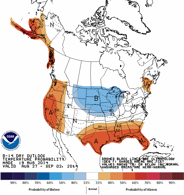
This graphic indicates that the trough of lower pressure that digs in over the Rookies will shift slightly to the east next week. This is also reflected in the model forecast off of the GFS (refer back to the last image in the series of GFS forecasts shown earlier). If this idea does come to fruition, then we could be in line for temperatures warming back above average by the middle of next week. However, this would be in response to the ridge of high pressure nudging eastward off of the Pacific and not from the Four Corners area.


