Saturday, December 31, 2022

Inland Northwest Weather Year in Review 2022

This year the Inland Northwest had no shortage of memorable and impactful weather events. As we welcome a new year, let's look back at some of the bigger weather events of 2022 across the Inland Northwest.


In January there was a massive snow event across Central Washington. This storm dumped 2 to 3 feet of snow on Wenatchee, Leavenworth, and the Methow Valley. Avalanches closed the Cascade mountain passes for days. A blizzard on the Waterville Plateau stranded motorists.


April was a busy month. A wind storm from a strong cold front produced wind gusts to 60 mph bringing trees down in Spokane, Pullman, and Lewiston. Winds also pushed an early season wildfire near Nespelem, WA. Blowing dust darkened the sky in the Lewiston-Clarkston Valley.


April was also a cold month. The entire Pacific Northwest had a cold April. Wenatchee had its coldest April on record including a big snowstorm on the 14th. Fruit trees in central Washington struggled to bloom and pollinate on time, as many other agriculture communities saw impacts from the cold and late blooming crops.


May brought two tornadoes to the Spokane area. May 6, a pair of EF-0 tornadoes produced damage within the city limits. Washington tornadoes are rare, but they do occur. The month of May is one of our most common months for tornadoes.


June saw flooding. A late Spring snowpack and frequent rain in June caused river flooding. The heaviest rain of the month fell on June 13 and 14 causing flooding in southeast Washington and the Idaho Panhandle. The Pend Oreille River was above flood stage for several weeks.


Following the flooding from June, July 4th had the flash flood in Conconully, WA. Slow moving thunderstorms occurred over the 2021 Muckamuck burn scar and send much and water into the small town of Conconully in Okanogan county, WA.


August was a busy severe weather month. Severe hail storms on August 11. Parts of eastern Washington and nearby Idaho were pounded by large hail and damaging thunderstorm winds. Swaths of crops were ruined. Cars and homes were also severely damaged by hail of golf ball size (2.75 inches) or larger. 


As to be expected, our fire season showed up. September and October saw lots of smoke. Degraded air quality was common in Chelan county and parts of far north Idaho late in Summer and into the Fall. Places like Leavenworth experienced smoke for weeks until Fall rains arrived. 


November started off on a snowy note. November 6 and 7 heavy snow. A swath of deep snow fell across north central and northeast Washington into far north Idaho. Many communities measured over a foot of new snow. Omak got up to 17 inches and a location near Republic got nearly 3 feet! People in Athol, Idaho saw 19 inches.


Closing out November, November 30 saw more heavy snow. Most of Washington state and the Idaho Panhandle got snow when this large weather system moved inland. Spokane got 7.5 inches, breaking  the snowfall record for the date. The Cascade mountains saw 1 to 2 feet of heavy snow.


Here's to a new year ahead with many more weather events to document and look forward to!

Monday, November 28, 2022

Update on the Wednesday Winter Storm


Yesterday's blog hopefully gave you a taste of the variability in the weather computer forecasts for the upcoming winter storm.  Late last week, the computer models had pretty good agreement on a heavy snowfall event.  But over the weekend, a few new scenarios developed for how much snow we will get and when.  Let's take a look at the latest forecasts to see if we have any new scenarios or possibly agreement.

There is good agreement on the start of the snow event, so we have high confidence for this. 

  • Light snow will start in the Cascades late Tuesday afternoon.
  • North-central Washington will get about an inch of snow Tuesday evening.
  • Snow should reach the Spokane/CdA metro by Wednesday morning.  
  • North-central Washington should have 3-5" of snow by sunrise Wednesday.
  • Snow will spread over the remainder of the Inland NW by about 10am Wednesday.
How much snow falls during Wednesday is still quite variable.  Most of the computer forecasts still point to the heaviest snowfall along a line from about Lake Chelan, to Keller, to Deer Park, to Sandpoint.  Here's the ECMWF forecast for this time period:


Most readers will note that the ECMWF still has a very low snowfall amount forecast for Spokane (i.e. 2.7").  It's been fairly consistent over the past 2 days of predicting a "low snow" event for the metro.

Compare that to the GFS, which has really stuck to its guns, saying that Spokane is going to get nailed with snow (11.5"):


What's interesting is that the 2 models have a similar overall pattern, with the heavy snow band oriented west-to-east.  The difference is in the exact placement.  If that band is farther north, Spokane will have a ho-hum event.  Farther south, and we're talking significant snow for the metro area.

Here's some other computer forecasts for that same time period:


Again all have the same basic overall pattern, just a little different in the exact location of the heaviest band of snow.  Here's a summary table for a few locations, along with the average of those 5 computer models.


ECMWF

GFS

Canadian

NAM

UKMET

Average

Spokane

2.5”

11.5”

5.7”

2.6”

5.2”

5.5”

Sandpoint

7.7”

5.1”

6.7”

3.7”

8.0”

6.2”

Pullman

3.2”

2.0”

5.8”

2.9”

5.3”

3.8”

Omak

2.9”

2.2”

1.9”

6.9”

3.0”

3.4”

Wenatchee

4.9”

2.1”

1.6”

3.2”

1.4”

2.6”

Moses Lake

1.6”

2.2”

1.3”

1.3”

1.7”

1.6”

Lewiston

0.7”

1.3”

0.5”

0”

0.2”

0.5”


Remembering from the previous blog, all of these numbers we shown you are calculated using a 10:1 ratio of snow vs liquid.  Given how cold temperatures are, the ratio will most likely be closer to 15:1 or even higher.  So all of these numbers should be increased about 50% to get a more realistic snowfall forecast.

For Thursday, the snow slowly sags into southeast Washington the southern Idaho Panhandle, as it ends in north-central and northeast Washington.  Pullman and Lewiston have their best chances for heavy snow on Thursday, with an additional 3-5" possible.

Looking at these forecasts (as well as other models not shown here), and adding local forecaster experience, this is the current official forecast for snowfall.


One other factor to address is that temperatures on Wednesday will get warmer. This isn't unusual.  A strong low pressure system off the WA/OR coast will bring warmer air northward.  The forecast high temperature at Spokane Airport is 33F, and 35F for downtown, which could limit snow accumulations in the afternoon a bit.  That won't be an issue for folks living to the north of Spokane.


Sunday, November 27, 2022

How much snow are we really going to get?


One thing forecasters do a lot of is looking at computer forecasts.  There are a lot of them to look at.  Some are generated by the NWS, some by other research agencies, some by other countries.  If all of those forecasts have agreement with each other, the forecaster confidence increases.  But we also realize that there are times that they all agree, but it turns out all of them were wrong.  So agreement doesn't always mean a slam-dunk gonna-happen forecast, especially when you're looking several days into the future.

Over the past few days, many have heard rumors or whispers that a major snowstorm is on the way for the Inland NW.  So let's take a look at what could potentially happen, and if the computers are still telling us to get prepared.

Saturday's GFS (U.S.) model looked rather snowy in eastern Washington for Wednesday.  9.6" for Spokane is a respectable storm.


The European model (ECMWF) had a similar look to it, albeit with a little less snow for Spokane (6.4") and a lot more for Sandpoint (14.3").


There are plenty of other computer forecast models we could look at it, all with varying snowfall amounts for Wednesday.  But you get the idea.  The majority of the forecasts pointed to a snowy midweek forecast.

The above graphics are based on a 10:1 Ratio of snow:liquid.  What is that?  We've all seen wet/heavy snow and dry/fluffy snow, and there's quite a bit of difference.  The way the computers (and forecasters) work is that they first predict the amount of liquid precipitation that is expected to fall.  Then based on a number of factors (e.g. air temperature), they use a ratio to convert the liquid into snowfall.  A 10:1 ratio means that if you have 1" of liquid, you'll get 10" of snow.  That's a fairly heavy snow, but it's close to the average.  If temperatures aloft are cold, that ratio could be 15:1 or even higher.  So that same 1" of liquid could produce 15" or more of dry fluffy snow.

Below is that same GFS forecast, accounting for the fact that the Wednesday snow event will be colder, and so the snow should be fluffier:


Now we're talking closer to a foot of snow for Spokane on Wednesday afternoon/evening, with still higher amounts to the north of the metro area.  Those kinds of numbers will get people talking.

The computer models are run 2-4 times each day, and each forecast comes out a bit different.  So what do the forecasts from todays computer runs say?  Here's the latest GFS forecast:


This is the 10:1 ratio forecast.  10.4" of snow for Spokane is even heavier than the forecasts from Saturday.  If we take into account the fluffiness factor, here's the GFS forecast:


So the GFS is still going for a significant snow storm for the Spokane metro on Wednesday.  But here's the ECMWF forecast from Sunday:


What in the heck happened?  1.7" for Spokane?  Why are we even writing a blog?  The ECMWF forecast has drastically changed.  And this happens a lot.  One computer forecast looks snowy one day, and then the next day it looks much different.  The ECMWF still gives some decent snow across the northern counties for Wednesday.  But for the Spokane area, the ECMWF is now looking snowy for Friday instead of Wednesday.

So which computer forecast should we believe?  At this point, one common approach is to take all of the various computer forecasts and average them together.  And that's largely what the official NWS forecast is for now.


There is still a lot of uncertainty in this forecast.  Confidence is higher for the northern counties, but much lower confidence for the I-90 counties.  Spokane/CdA could see 8-12" on Wednesday, so it would be wise to plan accordingly.  But if the European model forecasts are correct, this forecast will have to be revised considerably in the coming days.


Friday, November 4, 2022

Storm Part 2...Will your house have electricity in the morning plus a look beyond?

There's a good chance of seeing multiple power outages tonight with our upcoming wind storm.  And depending on how many outages there are, our much-appreciated hard working utility folks may not have all the power back on before you get up Saturday morning.  As such, you may want to make some contingency plans.  It would be a good idea to charge your battery powered devices this evening just to be safe. 

Round 1 of our storm series is over. The main result of it was heavy snow which fell over many parts of the Inland Northwest overnight and into this morning.  It is very unusual to have this much snow this early in the season, let alone for the first snow of the season. Here are the morning snow totals.  Since it snowed much of the morning, these totals will likely increase from what's posted here.


Now it's time to get ready for Round 2 and it could be a doozie: the wind storm.  The various computer models have their usual disagreements, but they're all saying it's going to be windy tonight.  One chart we often look at for wind events is the 850 mb wind forecast.  Think of this as the winds about 3000-5000 feet elevation.  Usually a wind of about 50 knots (58 mph) will get our attention.  In this instance, the GFS is forecasting 65 to 78 knots of wind tonight!  Other models so something of a similar magnitude.

850 mb winds for 11PM Friday

So the question is: can that wind that is 3000-5000 feet overhead mix down to the ground?  The answer is quite complicated and difficult to answer.  Meteorologists often struggle with this a lot.  In some instances, those strong winds above us stay above the ground and we never feel them.  But there are situations where those strong winds do make it to the surface.

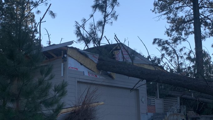
One of those mechanisms is cold fronts.  And that's exactly what we'll have moving through our area tonight.  The front is moving west to east, and will go through Spokane around 1am tonight.  Before that, the rain in the Spokane area will taper off around 6pm, and then the winds will begin to crank up.  It will be windy with gusts up to 50 mph late this evening and then the front plows through. We still think there is a good chance that when the front goes through, we will see wind gusts in the 60-70 mph range for some locations.  The damaging winds should begin to taper off  before sunrise Saturday.

Here's the peak wind forecast.  Keep in mind that the valley locations like Colville and Republic may not see the highest wind speeds, but they have more trees to potentially knock down and thus produce more power outages. 


So what can we expect from an event like this?  At this point, there are some similarities between this event and the 13 Jan 2021 event.  That event had 850mb winds of 57 knots just before the cold front came through, which resulted in a gust to 71 mph at Spokane Airport.  But similar to tonight's event, the strong winds only lasted about 3 hours.  Still, the tree damage was significant, and power outages lasted for several days in some locations.


After the wind storm, we aren't done with the active weather, we still have Rounds 3 and 4 to contend with. 

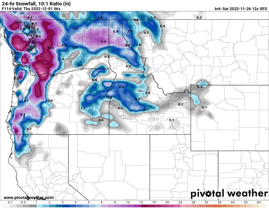
Round 3 promises to deliver more snow, and in some cases it could be significantly more than what we just saw. The heaviest snow possibilities are honing in on north-central Washington.  The surface low will track south of us, which favors that part of the Inland NW due to easterly low-level winds pushing into the Cascades. This will cause rising air over much of that area, rather than the more typical downslope/rain shadow effect.  Snow should start there on Sunday morning.

Surface low position (off Vancouver Island at 11 am Sun) and precipitation

But since this low is tracking south of us, the front will move very slowly across the region.  It won't reach extreme eastern WA and the Panhandle until 24 hours later, Monday morning.

Surface low position and precipitation as of 11 am Monday

Here's the current forecast storm total snow for this event.  


And lastly, Round 4 will be the unusually cold temperatures that move into the region behind this storm.  There's a good chance that some locations will break daily records.  Here is a list of the record highs which could be broken (denoted in yellow):


As well as the record lows (denoted in yellow):


If there are widespread power outages from the wind or upcoming snow event, the cold temperatures next week could have a much bigger impact than they usually would. 


Wednesday, November 2, 2022

Incredible Series of Weather Events for the Inland NW

Thus far the Fall of 2022 has been an unusually mild one. For the Spokane area, the period from September 1st through October 31st was the 3rd warmest on record and the warmest since 1952. 

Top 10 warmest Sep-Oct on record for Spokane


It was also the warmest October on record for Spokane, by a relatively impressive 0.5°F. 


And this is despite a transition to a slightly cooler and wetter pattern for a cooler stretch of weather between the 21st and the 26th. 


And it wasn't just Spokane that set records. According to data from the Climate Toolbox, it was the warmest September-October across much of the the Inland Northwest between the years of 1979-2015. 


This weather pattern was a direct result of an anomalously strong and persistent ridge of high pressure over the West Coast of the US with the upper level jet stream or storm track bottled up over southern Alaska and the Yukon. 
Mean Jet Stream Position for 9/1/2022-10/30/2022
Positive height anomalies centered over SW Canada and the Pacific Northwest show how this pattern deviated from the normal jet position. 


So why are we showing you this? Well first off  it will likely be the warmest and mildest weather we will see at least until next spring, but that's not the big news. The big news is we are headed for a major transition in our weather pattern. And this will be a direct result of the jet stream taking a dive to our south...in fact well to our south. But before we get there we have some very active weather to get through. 

Weather enthusiasts usually have to wait a while for a high-impact event to come along.  That's what makes this upcoming set of weather events so impressive.  We won't be able to give a ton of detail to each event or this blog would run on forever.  So we'll try to hit the high points.

The first act will be the snow.  This will be the first snow of the season for many lowland locations in the Inland NW.  The precursor is already in place, namely, a cold atmosphere.  That is complements of the very slow cold front that moved through the region on Monday and Tuesday and has left an unstable and cool trough located over the area this evening (11/2/2022). 

Jet Position 11/2/2022 5pm

 This has lowered our temperatures aloft to well-below freezing now, so snow will be the predominant precipitation type when the next storm arrives tomorrow night.  
Here is what the upper level jet looks like for tomorrow evening. The deep trough located over the Inland Northwest this evening will quickly be replaced by more stable and moisture-laden air mass with the jet gradually tracking to our north. 

Jet position 5 pm Thursday 11/3/2022

And here's the resultant precipitation forecast from the GFS for early Friday morning:

Precipitation Forecast for 5am Friday 11/4/2022


Now some of the computer models are forecasting a heavy snow event for a few locations, most notably the Idaho Panhandle and Northeast Washington.  

24 hour snow forecast ending Thursday 11am 11/4/2022


But the issue that these models don't really account for is that;
  1. The surface air temperatures won't be all that cold. Most locations will be right around freezing by the time the precipitation begins on Thursday night and hold somewhat steady through the night.  
  2. The ground temperatures are still considerably warmer than freezing, since it's only early November.  
So while some folks in these areas could get some impressive snowfall, it will be the wet, heavy type and shouldn't accumulate on roads very easily, if at all. The problem with warm fronts is that warmer air follows the snow.  And in this case, the warmer air will melt all of the snow by Friday night and change any remaining precipitation to rain.  So take your "first snow" pictures quickly.

Our snow storm is followed by a strong wind storm Friday night as the cold front comes marching through.  An impressively strong 160 knot jet stream will be right over our area Friday night and Saturday morning.  This is not good news.

Jet Position Saturday morning 11/5/2022


Meanwhile, a strong surface low will be deepening (i.e. getting stronger) as it tracks across southern British Columbia.  This pattern is well known for strong damaging winds in our area.  Many locations will see wind gusts of 45-50 mph and a few gusts to 60 mph are possible.

Surface weather map and precipitation forecast for 11pm 11/4/2022

The biggest fly in the ointment could be a non-meteorological factor: tree leaves.  Our mild fall has meant that the deciduous trees are decidedly late in losing their leaves.  This could have implications for both the snow and the wind.  If the temperature is just right (not to warm or too cold), wet snow will stick to the leaves, adding considerable weight to branches that aren't accustomed to it.  The resulting tree damage could temporarily block roads and cause power outages.  

 Tree damage from a moderate October snowfall in 2019 with fully leafed trees. 

The same goes for the strong winds.  Trees with leaves tend to "catch" more of the wind, which could also increase the tree damage and power outages.

Our Saturday will still be windy, but mostly dry.  This will serve as the breather between the weather systems.  And it doesn't last long.  The next Pacific storm will follow a different track, moving by to our south.  This track favors heavier snow for the Cascade folks (Omak and  Wenatchee) and less snow for other locations.  And the snow won't change to rain with this pattern.  Also in the image below, you can see all of the thin black lines, or isobars,  over the Idaho Panhandle and northeast Washington.  That means cold, brisk northeasterly winds as an arctic air mass pushes in from Canada.


The resulting snow totals could be rather impressive for the Cascades.  The GFS forecast is pretty impressive, and the ECMWF forecast (not shown) is equally significant.  


The GFS Ensemble (think of this as the average of 30 different perturbations or varieties of the initial GFS model) also points to heavy snow potential for north-central Washington.


Remember, this is still 4-5 days out.  The forecast keeps changing, so we wouldn't hang our hat on this scenario at this point.  Everyone in the Inland Northwest should keep checking the forecast updates over the next couple of days.

The last act in this string of weather events will be the unusually cold conditions.  We have much higher confidence of this than snow amounts or wind speeds.  The cause of this pattern shift will be the upper level jet plunging well south of the area with the air mass coming out of the Yukon or Northwest Territories. 

Jet position for Monday 11/7/23

Daytime temperatures will remain below freezing for many locations next Monday through Wednesday (if not longer), with nighttime temperatures in the 20s and teens.  Here's is the high temperature forecast from the ECMWF ensemble for Tuesday:


In case you were wondering, yes some of these forecast values are record cold highs for the date. The record cold high for 11/7 is 32°F set in 2017 and we have a forecast of 33°F. The forecast for 11/8 is 30°F with the record for the date being 26°F set in 1945. 

So there you have it.  A Thursday night snow storm chased by a Friday night wind storm  and then followed by yet another snowstorm for Sunday night.  The end of the story will be a very good chance of seeing an unusually early arctic cold snap next week.  Remember, November is still an autumn month although it won't feel much like it. And by the way, the latest 8-14 day outlook isn't giving much of a chance of breaking out of this cold pattern anytime soon.