Friday, January 31, 2014

Cold Weather is on its way

We've had a major shift in the weather pattern over the past few days.  Most of you have probably noticed this with the return of snow followed by some sunshine, and the end of the fog and stratus.  The change in the jet stream pattern was somewhat subtle, but profound.  In our last blog we talked about the end of the high pressure over our area.  Here's what the pattern looked like on January 27th:

Jet Stream (red line) on 27 Jan 2014


The red line is the jet stream.  Storms from the Pacific were diverted up into Alaska, over the top of the high pressure ridge, and then down into the central and eastern US.  Compare that with the jet stream pattern today:

Jet Stream (red line) on 31 Jan 2014

The ridge of high pressure is now over the eastern Pacific.  The jet stream is now diving from Alaska into the Pacific Northwest.  (As a side note, there is another branch of the jet stream that is directing a few storms into California, which is good news for them).

While we've seen some snow and sun as a result of our pattern change, the biggest effect will arrive next week:  cold air.  This won't be the bitter cold that the eastern US experienced recently, but we'll still be plenty cold.  Starting Tuesday, most locations will remain below 20 during the day and drop into the single digits at night.   The forecast from the GFS model for Spokane is shown below.  

Temperature forecast from the NAM (red/orange lines) and GFS (blue lines) for Spokane
Here's our current high temperature forecast for next Wednesday:


And then Wednesday night, temperatures will drop to near zero for most locations.   As we've discussed before, the ingredients for really cold nighttime temperatures are clear skies, light winds, and snow on the ground.  Take away one of the three, and the temperature can be 10 to 15 degrees warmer.  So forecasting low temperatures in these situations has a large potential to be wrong.


Before the cold arrives, there will also be a disturbance in the jet stream that will move through the area on Sunday.  It will bring more snow to the region, mainly the southern Panhandle.  Here's our current snow fall forecast:


Friday, January 24, 2014

How long can this stagnant weather go on?

By now, most of you may be getting tired of our boring, foggy weather.  On the positive side, you haven't had to shovel any snow, and the roads have been in decent shape, except for some occasional icy spots from freezing drizzle.  But the gray skies do tend to wear on some folks.  Here's what it looks like from space.


Visible Satellite 1/23/14

That white area in the middle of the picture is the fog and stratus that has filled in the Columbia Basin of eastern Washington and north-central Oregon.  You can see some mountains above the fog near the Washington/BC border, as well as the Washington Cascades.

Why are we stuck in this pattern?  High pressure over the western US is steering storms away from our area.  As we've discussed in past blogs, this is causing a severe drought in the western US.  But for many in the West, they're enjoying sunshine and warmth.  Take a look at this satellite image to see what we mean:


Western US Visible Satellite picture 1/23/14

So why are we so cloudy while the rest of the West is sunny?  Professor Cliff Mass of the University of Washington wrote about this in his blog.  You can find it at:  http://cliffmass.blogspot.com/2014/01/cloud-bowl-of-eastern-washington.html  We highly recommend it.

But in short, the reason is three-fold.  First, the Columbia Basin acts as a topographic bowl.


 The Columbia Basin is bordered by the Cascades to the west, the Selkirks to the north, the Panhandle mountains to the east, and the central-Oregon mountains to the south.    A perfect bowl.  Note in the above picture of the western US, the Central Valley of California also provides a nice elongated topographic bowl.

Second, you need moisture in order to form fog.  And while we have been very dry, we still have had weather systems providing some moisture.  Coupled with the cold nights, and you get fog and stratus to form.  The Central Valley of California has been so dry this winter, they can't even produce fog! 

The third ingredient is a lid to put on the bowl of fog, to prevent it from going anywhere.  This is provided by the ridge of high pressure.  High pressure results in sinking air.  Sinking air warms. So while at the surface we're stuck in cold, sub-freezing temperatures, the air above us is much warmer.  Locations in the mountains as high as 5000-6500'' have been reaching the mid-40s each day.   The high pressure also keeps storms away from our area.  Storms mean wind, and wind mixes the air which dissipates fog. Below is a temperature and moisture sounding or profile taken at our office on 1/23 at 3 pm. There are two pink lines on this chart, the one on the right denotes how the temperature changes with height. The line on the left is the moisture profile. The farther away the two lines are from one another, the drier the air.  So on this sounding, most of the atmosphere is clear and dry. The exception is near the ground where our temperatures have been stuck in the mid 20s to lower 30s for days and the sun has been a rather rare site. Notice how the temperature increases with height and peaks at 47° at an elevation around 6500'. So if you seeking sun and warmth, the mountains are the place to go. 

Spokane temperature sounding 3pm Thursday. Light pink line or right denotes the temperature profile. 


One positive of this weather has been the beautiful natural flocking which has adorned most of the objects stuck in fog for the past week. This flocking is being produced from the deposition of small sub-freezing water droplets on objects resulting in riming. The rime in this event is covering everything from trees, fences and power lines.  We wrote about this back in December.  You can read about it at: http://inlandnorthwestweather.blogspot.com/2013/12/another-kind-of-white-weather.html  

Here's some pictures from our office:


So this kind of weather can't last forever, can it?  No, but it can last for a few weeks.  This episode started on January 16th, and today is the 24th.  Yep, it's only been going on for a week.  Seems like a month though.  Have we seen longer episodes in the past?  Of course.  One of them occurred during the 1976/77 drought.  After a few storms brought rain and snow to the area in the middle of January 1977, a huge area of high pressure developed over the area, just like our current episode.  Spokane and the Inland NW were stuck in the fog from the 19th of January through February 10th.  That's 22 days!  Although there were a few peaks of bright sunshine during that streak they quite brief.  A weak weather system moved through at the start of February, but it was too weak to get rid of the fog.  Instead, they had some freezing rain.

How long will our current episode last?  Aside from a few possible sun breaks, we're likely stuck in the fog through the weekend and into early next week.  There's a outside chance that some locations in the Panhandle and northeast Washington will see more sun on Monday.  This is due to an arctic high pressure system centered over eastern Montana and the Dakotas that may push a bit of drier air into our area from the east.
7am 1/27/14 precipitation and sea-level pressure forecast from GFS model. 

Despite the presence of the weak system notice the 500 mb ridge (below) remains very amplified and basically centered over the Pacific Northwest. 

500 mb pattern for 7am 1/27/14  GFS model.


Starting on Tuesday, some very weak Pacific weather fronts might be able to break up the low clouds as well as bring us a dusting of snow as the ridge gets progressively weaker each day.   By the end of next week, there is more confidence that the weather pattern will have changed and we can get a respite from the fog and low clouds.


4am 1/28/14 500 mb map from GFS.
Ridge gets flattened a little by weak front. 

7am 1/30/14 500 mb map from GFS.
Ridge is virtually gone now over PacNW and is replaced by a trough off the coast. 
And this ridge breakdown could actually persist for more than a couple days. The map below is the mean 500 mb pattern projected for the period from January 30th-February 3rd. Notice the ridge has generally shifted into western Alaska and has left a broader trough over most of the US, including our area. The 8-14 day outlook (bottom image) through February 7th looks similar as well. 
6-10 day outlook. Mean 500 mb map. 

8-14 day outlook., Mean 500 mb map 


Thursday, January 16, 2014

Does a dry winter lead to a bad fire season?

We have received many questions from the public inquiring whether our dry start to the winter will equate to a bad fire season this summer. Common sense would suggest that if the fuels begin the fire season on a dry note that should increase the risk of fires later in the year. But is that necessarily true? Before we address that notion, lets review the weather pattern thus far this water year and what the weather looks like for the remainder of the winter. For climate purposes in the western U.S., the water year is defined as the 12-month period beginning in October. Since October, the western U.S. has generally been affected by a persistent ridge of high pressure fixed just off the coast. Meanwhile, the remainder of the U.S. has seen a rather persistent trough of low pressure. This scenario is reflected in the mean 500 mb (~18k ft MSL) seen below. Notice the large buckle in the flow centered just of the western coast of North America and the dip over the eastern half of the continent.
500 mb pattern October 1-January 12 2014

This is a rather unusual flow pattern. The typical flow pattern for this time period generally features swift west-southwest flow into the region as seen on the map below. This southwesterly flow often draws deep moisture from the sub-tropics and slams it into the Pacific Northwest (think Pineapple connection or atmospheric river). This setup produces frequent and heavy precipitation, especially west of the Cascades. 
Typical 500 mb pattern October-early January.

When we compare the top image (October 2013-early January 2014) to the bottom were are left with some pretty sizable departures from the normal which is termed an anomaly. The biggest anomaly this wet season was the huge red bulls-eye centered over the Gulf of Alaska. This is the culprit responsible primarily for our unusually dry winter thus far. 
500 mb anomaly (red=higher than normal heights, blue=below normal heights)

So climatologically speaking, how has that translated to the precipitation departures from normal across the area? As you can probably guess, the precipitation this wet season has been quite meager.  Most locations across eastern Washington have seen less than half the normal amount of precipitation with locations near Wenatchee, Omak, and Moses Lake seeing less than 25% of the normal precipitation (dark red). As of January 13th, both the Omak and Wenatchee areas have received less than an inch of precipitation since October 1st, and both were the 2nd driest on record, only trailing an even drier 1976. 
October-December 2013 precipitation percentages of normal. 

An obvious implication of this lack of precipitation was an even more impressive lack of snow pack and the water contained in that pack. Needless to say our snow pack is running much below normal, especially in the Cascades where totals were hovering between 50-75% of normal (yellow and orange shading). Conditions were significantly worse across Oregon and California (not shown).

Current snow water equivalent 
So being as dry as it's been can we expect to recover to near normal conditions by the end of winter. Based on past winters with similarly dry beginnings, the answer is no. See this previous blog link for more details. So does the weather in the next 8-14 days look promising for ending or at least lessening this dry winter pattern? The answer to that is also no, as as the strong eastern Pacific ridge is expected to rebuild and remain fixed over the region (note ridge axis right off the coast) for the next couple weeks. Below is a map of the mean 500 mb pattern expected over North America through the end of the month. 

Mean 500 mb pattern expected through end of January

This translates to little promise for appreciable precipitation (dark brown area over Washington is a 60-70% chance of below normal precipitation) 

Precipitation probability Jan 24-30, 2014
Based on the current dry conditions and little improvement expected anytime soon, can we assume that will translate to a busy fire weather season? To determine that answer we took a look at annual fire acreage across the Inland Northwest since 1970 and compared it to the winter precipitation conditions that preceded it. We first took a look at the precipitation measured at the Spokane Airport between October 1st and January 15th and ranked those values. We then compared these precipitation rankings to the amount of acreage which burned in the following fire season. Below are the results. 

Of the 10 driest October-January 15th periods in Spokane,  4 of the following fire seasons resulted in above-average fire acreage (average burned acreage is 61,000), while 5 saw well below-average fire activity. That alone would suggest there isn't any correlation between a dry winter and a bad fire season.  In fact, the driest year, 1976-77 only resulted in the 26th ranked fire season. But note that 4 of the top 6 fire seasons are in this list (2001, 2012, 1994, 1970).


Top 10 driest Oct-Jan 15th since 1970  in Spokane and the following amount of burnt acreage
  If we rank the seasons based on precipitation in Wenatchee, the message is still muddy. Four of the following summers were active fire years, but the other 5 were below normal.

Top 10 driest Oct-Jan 15th periods since 1970 in Wenatchee and the following amount of burnt acreage
This suggests that a dry beginning to winter doesn't necessarily lead to a busy fire season. What about the opposite? Does a wet season lead to a quiet fire season? 


Top 10 driest Oct-Jan 15th periods since 1970 in Spokane and the following amount of burnt acreage

Similar to the dry winters, the numbers are about evenly split. Four summers following wet winters had active fire seasons, and 5 were less active.  In fact, the wettest Oct through mid-January (2006/2007) was followed by the largest fire season since 1970.

              
Top 10 driest Oct-Jan 15th periods since 1970 in Wenatchee and the following amount of burnt acreage
In Wentachee the 10 wettest winters since 1970 led 6 of the quietest fire seasons (ranks of 35 or higher). So perhaps a wet winter could yield a fair prediction to a slow fire season, especially when considering the Wenatchee precipitation. After all, most of the fire acreage in the Inland Northwest typically burns near the Cascades. This all makes sense, since a wet winter will typically yield a large snow pack which will take longer to melt.  So the higher elevations have no chance of wild fires until much later in the summer, if at all, which reduces the amount of forest available to burn during the summer.

So what does all this mean?  Most large fire seasons are the result of the combination of lots of lightning and dry fuels.  Just because you have one, doesn't mean you'll get the other.  So even if you have a dry winter, a quiet lightning season will result in a quiet fire season.  However, as we saw from the tables above, a dry winter lead to 4 of the top 6 fire seasons.  Meaning, if you do happen to have an above-average fire year, it has the potential to be a really bad year.

Wednesday, January 8, 2014

Snow, Rain, Wind, (and Thunder?)

Yesterday's weather system brought a nice 1 to 3" of snow to many locations.  You can see an extensive list of snow reports on the National Weather Service website.  Now we have Storm #2 arriving 24 hours later.  This one will be a little different in a couple of ways.  First, this storm is a little wetter and more extensive than the first.  This means more people will see precipitation.  Here's the radar forecast from the HRRR model valid at 5pm this evening:


5pm radar forecast from the HRRR model

This is a forecast from a computer, not an actual radar image.  But it gives you an idea what the radar will look like around 5pm.  And just about everyone in the Inland NW will be seeing some sort of precipitation at this time.  Which leads us to the other difference.  While Storm #1 was all snow, this one will be more of a mixed bag of rain and snow.  The HRRR forecast for precipitation type at 5pm is shown below.


5pm precipitation type forecast from HRRR
This graph is a little hard to read, but the horizontal blue lines represent snow, while the vertical green lines are for rain.  The HRRR expects the precipitation by 5pm to be rain south of a line from Deer Park to Grand Coulee.  This includes Spokane and the Palouse.  The precipitation may initially start in the metro area as wet snow, but it won't be able to accumulate much and will change to rain later this afternoon. Also notice there are some small pockets of red scattered around the region. This represents a chance of freezing rain. If freezing rain really does occur it will be rather isolated and likely quite brief. 

Here's the storm total snow forecast from the National Weather Service.


Storm total snow ending 4pm Thursday


Most of the valleys across the north (Republic, Colville, Sandpoint) will see all snow and pick up 2-6" of snow, while the mountains will receive up to a foot.

Storm #3 will follow on Thursday afternoon/evening this will be a weaker system.  It will once again bring rain or snow to Spokane and the Palouse while the northern valleys will pick up a little more snow.

Storm #4 is still taking shape but it consistently looks like it will be the strongest of the bunch.   Today's GFS model forecast backed off a little from it's previous forecast, while some of the other models came out a little stronger today.  As a result, they're all in very good agreement at this time.  We often take this as a sign to increase our confidence in the forecast.  Even though they all agree, could they all be wrong?  Yes, but the odds are growing increasingly slim.  

Here's a breakdown of how this storm will unfold:
  • Precipitation will spread over the area on Friday around or shortly after sunset.
  • Spokane and the Palouse will see rain from this storm, with a possible mix of snow at the onset.
  • Saturday morning will be rainy and breezy.  Spokane will be in the lower 40s by sunrise and top out in the mid 40s during the day.
  • The northern valleys will start as snow and will accumulate a few inches.  They will gradually change to rain overnight.  Colville will probably change to rain before midnight, while Bonners Ferry could hold on to snow until Saturday morning.
  • The cold front will move through the area during the middle of the day.  Behind the front winds will really blow.  Below is our forecast peak winds for Saturday.  Areas in white can expect gusts in excess of 50 mph.

Peak wind gusts expected on Satuday

We will likely be issuing Wind Advisories for much of the area and possibly High Wind Warnings.  You'll want to stay tuned to this forecast.

Here's a couple of other things to consider with this storm.  The rain along with the melted snow won't be able to soak into the ground since the ground is solidly frozen (from our early December cold snap).  So expect some water  ponding, even on your lawn.

The other interesting tidbit is the outside chance of a thunderstorm.  Thunder?  In early January?  Yes, it's happened before, and this is pretty much the classic set up for it:  warm moist air ahead of a strong cold front.  Below is the SREF model probability of thunderstorms. 

24 hr thunder chances ending 10pm Saturday. 
You can see a small area of 10% over southeast Washington.  If thunder does occur, we don't expect to see hundreds of lightning strikes. However a few claps of thunder are a possibility especially over southeast Washington and the southern Idaho Panhandle, including Pullman and Lewiston. 


Tuesday, January 7, 2014

A big storm for the end of the week?

Looks like we do have a series of weather systems poised to move through the Inland NW over the next few days.

Storm #1 will be the weakest and will arrive Tuesday afternoon and night.  It should bring widespread light snow to the area, which will start late this afternoon.   The image below shows how much snow we are expecting by Wednesday morning.  


The official forecast is for Spokane and Coeur d'Alene to see between 1" and 2".  The HRRR (3km Rapid Refresh model) is forecasting a bit more snow.  It suggests 1-2" for western Spokane but 2-3" for Coeur d'Alene and Deer Park.   The NAM and GFS models (not shown) forecast more like 3-5" for the metro area, but these predictions have been trimmed back because the majority of this system will be moving by to the south of Spokane. The heaviest snow will be east of Moscow, ID.  


Some of the road pavement temperatures could be above freezing in some areas when the snow starts.  As we've discussed before, in these situations the initial snow fall will melt on the roads.  But since the air temperatures and ground temperatures are below freezing, the melting process quickly cools the road surfaces back to freezing.  This causes the melted snow to freeze to the road surface as more snow accumulates.  The result is very slick roads.  

Storm #2 will arrive Wednesday afternoon.  A bit stronger than Storm #1, it will start to push some of the cold air out of the area.  As such, precipitation will start off as snow in Spokane and the Palouse but change to rain Wednesday evening.  The northern valleys should remain as snow through Wednesday night for this event and could see a few inches.

The potentially big storm arrives late Friday.  This will be a valley rain / mountain snow event.  Precipitation in the Panhandle mountains will likely be considerable, with snow levels rising to 4000' in the north and 5000' in the central Panhandle.

The cold frontal passage will occur sometime on Saturday.  All of the models show strong winds with the cold front.  But the GFS has the strongest winds, all thanks to a very deep low.  The image below shows the GFS forecast for Saturday morning.


At this point, the GFS forecast's a 980mb low over central BC.  Twelve hours later, the low has moved into the Canadian prairies and deepened to 976mb.


This is a very good pattern for strong winds in our area.  But, as we said, the other models, while windy, are not as strong as the GFS model.  So at this point, we have a windy forecast.  But if the other models start to trend towards the GFS model, we'll be increasing the winds in our forecast.


The image above shows the predicted peak wind speeds.  Areas in white would be over 50 mph.  Stay tuned to the forecast for this storm.  We'll probably update the blog Wednesday or Thursday.

Friday, January 3, 2014

A dry start to the wet season

You might not have noticed, but it's been exceedingly dry in the Inland Northwest this winter. The lack of snow is obvious, but we haven't been getting much rain either.  Below is a map of the precipitation deficit across the West for the October through December period.

Precipitation departure across the western US from 10/1-12/31

The "warm" colors (yellow, orange, red) show areas of below-normal precipitation, which encompasses all of Washington, Oregon, and Idaho.  The largest deficits are on the coast because they normally get the most precipitation.  The Washington coast is more than 20" below normal! The image below shows the percent of normal precipitation.

Percent of average precipitation for 10/1-12/31


This image shows that California is exceptionally dry, but eastern Washington is very dry as well.

But in the West, we rely the snow pack in the mountains for much of our water supply.  So let's take a look at how the mountain snow pack is faring this winter.

Percent of normal snow water equivalent (SWE)

The map above depicts the water content in the mountain snow pack as a percent of normal. For example, the mountains of north central Washington contain 68% of the snow water content or snow water equivalent  they would normally have on January 2nd.  The Washington and Oregon Cascades have very little snow, only 17% to 48% of normal snow water equivalent. The water content is slightly better in the Idaho Panhandle mountains, but still below normal.

We can also look at the precipitation at selected locations.  Below is the graph from Lyman Lake, which is in the Cascades, west of Lake Chelan.

Snow water equivalent for Lyman Lake, WA

The black line shows the current year, and compares it to normal (green line) as well as the driest (red line) and wettest (blue line) years.  As you can see, on the 1st of January, the snow water equivalent (the amount of water in the snow pack) was below the red line, meaning that this is the lowest snow pack on record at that location for the beginning of January.  Records for these sensors only go back into the 1980s, so saying this is a "record low snow pack" is pretty misleading.  

Here's the data for Lookout Pass in the Idaho Panhandle:

Snow water equivalent for Lookout Pass, ID

The snow pack in the Panhandle Mountains is a little better than the Cascades.  Not the driest ever, but still well below normal.

So this all begs the question: Why has it been so dry?  Below is an image showing our average jet stream for the Oct-Dec period.
Mean Jet stream position 10/1-12/31

The shading shows wind speed.  The black line is the jet stream.  Storm systems follow the jet stream.  So this year, storms from the Pacific are being steered into western Canada, and then they descend into the eastern US. In other words, the storms are missing the Pacific NW.

Here's what the jet stream pattern normally looks like:
Normal jet stream position for 10/1-12/31

In a normal year, the jet stream is pointed directly at the Pacific NW. 

So is there any hope that this pattern will change?  We don't have forecasts out for the rest of the winter.  So instead, let's look back at past winters that started off dry like this year. 

The table below shows the 16 driest October-December periods in Spokane. This year is the 3rd driest so far (tied with 1929). 

Driest October-December periods in Spokane

So how did the remainder of the winter into early Spring fare in those years, and is it possible to make up the precipitation deficit? As you see below. The odds are not good. In fact only one of those years was able to see the precipitation total climb to normal (1969) and even then it just barely made it. In most cases, the total October-March precipitation was 75% or less of the climatological normal after an unusually dry start to the water season (a western US water season begins in October).

October-March Precipitation for the 16 driest preceding October-December periods

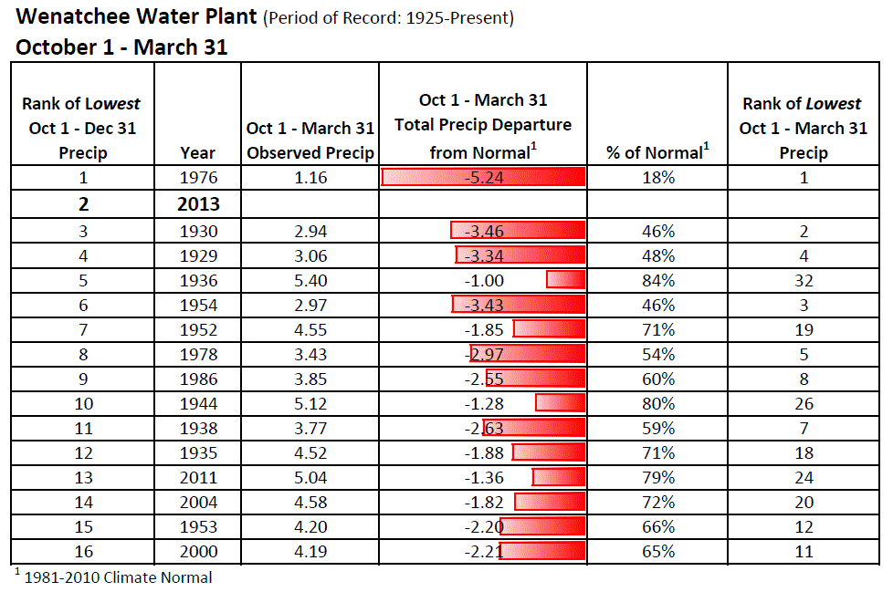
Do the climatological trends look any different for Wenatchee? The table below shows the driest October-December periods. This years precipitation total since October in Wenatchee is a mere 0.75" or 22% of the normal. This is the second driest beginning to the late fall and early winter season since 1976.

Driest October-December periods in Wenatchee

So were any of those dry years able to make up the precipitation deficit during the second half of winter? Nope. 16 out of 16 years ended the season with below normal precipitation and much like Spokane, most saw only 75% or less of the climatological normal.


October-March Precipitation for the 16 driest preceding October-December periods

So as you can see from a climatological standpoint, our odds of seeing a normal or above normal amount of precipitation between October and March is quite slim.