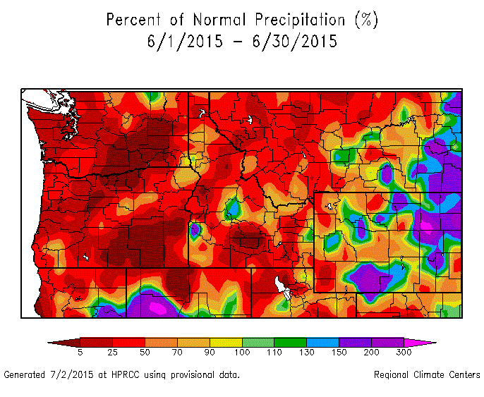
All of the areas in dark red had their hottest June on record. And for precipitation, this was one of the driest:

This past June wasn't just a little warmer than normal, it was crazy hot. It was actually hotter than most Julys or Augusts. The 105F at Spokane Airport wasn't just the hottest June day ever, it was the 5th hottest day in Spokane history (click here to see a discussion of the hottest day ever in the Inland Northwest). It's interesting to note that Europe was also extremely hot.
- Germany set it's all-time hottest temperature ever this year on July 5th with a temperature of 104.5F.
- Paris had it's second hottest day ever on July 1st with a reading of 102.2F.
- Geneva hit 103.5F, an all-time record for that city.
The two most frequent questions that we're hearing are: 1) will this be the hottest summer ever? 2) what caused the record June heat?
In order to answer question #1, it's always best to look back at history. While we've never seen a June as hot as this, there have been some historical hot Junes. So what happened for the rest of the summer in those years? Below is a table showing the 10 warmest Junes and the average temperature anomaly for those years.
Average Temperature Anomalies for the 10 warmest Junes
Year
|
Jan
|
Feb
|
Mar
|
Apr
|
May
|
Jun
|
Jul
|
Aug
|
Sep
|
2015
|
+3.8
|
+7.3
|
+6.0
|
+0.1
|
+5.2
|
+9.1
|
?
|
?
|
?
|
1922
|
-6.7
|
-5.8
|
-2.6
|
-2.8
|
+0.9
|
+7.6
|
+3.2
|
+2.2
|
+3.1
|
1940
|
+2.8
|
+4.0
|
+5.8
|
+3.2
|
+5.0
|
+6.0
|
+2.8
|
+1.9
|
+5.1
|
1918
|
+4.4
|
-0.3
|
+3.5
|
+2.4
|
-2.0
|
+5.9
|
+1.7
|
-2.8
|
+5.2
|
1992
|
+4.5
|
+7.0
|
+6.0
|
+1.4
|
+3.3
|
+5.7
|
-2.3
|
+0.8
|
-2.3
|
1938
|
+4.3
|
+1.7
|
+1.6
|
+2.4
|
+1.4
|
+4.5
|
+5.0
|
-0.9
|
+8.2
|
1903
|
+4.9
|
-4.2
|
-0.5
|
-2.6
|
-1.3
|
+4.3
|
-4.5
|
-1.4
|
-4.1
|
1961
|
+3.1
|
+5.1
|
+0.4
|
-2.3
|
-2.5
|
+4.3
|
+1.9
|
+5.3
|
-3.7
|
1982
|
-1.0
|
+0.2
|
+0.7
|
-3.9
|
-1.3
|
+4.2
|
-2.5
|
+1.1
|
-0.2
|
1932
|
-1.1
|
-2.2
|
-1.2
|
+2.6
|
+0.2
|
+4.1
|
-0.9
|
+0.9
|
+1.7
|
This year has been at or warmer than normal for each month. Some of the past hot Junes seem to have "come out of nowhere", such as 1922 where the winter and spring months leading up to June were colder than normal. While 1940 was just plain warm, with every month above normal. Some years are similar to 2015 (1992, 1938) in that they had mild winters/springs with a hot June. But in those years, the remaining months of July-September were not consistently hot.
Overall, the historical numbers show us that while the July-September period following a hot June are often warm as well, it's far from a slam dunk.
July is almost half-way over and while temperatures have recently cooled, we're still running several degrees above normal. The NOAA Climate Forecast System continues to predict a warmer than normal Aug-Oct period. So the odds are good that we'll above-normal temperatures for the next few months and possibly longer (see below).

This leads to the second question: What caused this hot spell? The answer to this is much more vague, but it's possibly related to El Nino. The equatorial water of the Pacific (where El Nino is monitored) has been showing a steady warming for the past 9 months.
 |
| Equatorial Pacific Sea Surface Temperature amonalies |
The Nino 3.4 region (second graph from the top) shows that El Nino conditions were barely met (i.e. greater than 0.5C anomaly) through much of this past winter. And most climate folks agree that the weather patterns we saw this past winter were not typical of El Nino (remember all the snow and cold in the Northeast?). In a typical El Nino event, the signal will begin in late summer, reach a peak in mid-winter, and then fade during the spring. But this year, the warming strengthened during the spring and summer months.
Typically, the presence of El Nino has little effect on summer weather in North America. But the weather patterns this year of late spring and early summer resembled those of El Nino. And the 3-month precipitation anomaly for this year looked El Nino-like, with wet weather in the southern states (remember all the Texas flooding in May) and dry weather in the Pacific NW.

So was El Nino partly to blame for our hot June? It's impossible to say with any certainty. Our last warm June (1992) had a moderate-strength El Nino in the preceding winter that was fading out by June. And the super El Nino in the winter of 1982/83 had a warm June in 1982.
Some of you may be hearing projections of a "strongest El Nino ever" for this upcoming winter. Is there any truth to these, or are they just media-hype? Here's the El Nino prediction from the NOAA CFS model:

The solid black line is the Nino 3.4 temperature anomaly back to 2014, showing the gradual warming. All the thin red and blue lines are forecasts, and the black dashed line is an average of the forecasts. As you can see, the average forecast peaks at just over 3.0C around November.
Below is a similar forecast from the ECMWF:
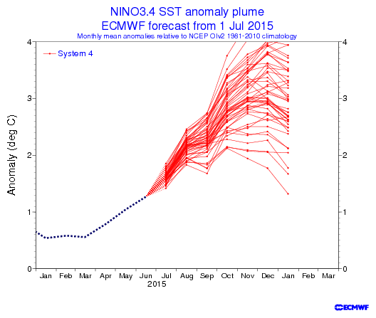
This graph doesn't show the average of all the red forecasts, but you can see that it would be somewhere around +3.0C, peaking in November/December as well.
The official definition of a "strong" El Nino is a 3-month average anomaly greater than 1.5C for 5 months. These forecasts certainly suggest a strong El Nino for this winter. And to put it into historical context, there are only 2 winters with El Ninos as strong as the one currently forecast: 1982/83 and 1997/98. Both of these winters had a strong impact on the winter weather in North America. We'll be writing more about El Nino in the coming months as the details become clearer.