Monday, August 31, 2015

Does this mean summer is over?

Our hot summer came to a screeching halt on Sunday with a Pacific cold front bringing our first widespread rain in what seems like months.  The forecast for this week is decidedly cool, with daytime highs in the 70s and lower 80s.  And one look at the calendar begs the question:  Did summer just end without any warning?  Kinda felt like autumn on Sunday didn't it?  And we often say that on average, summer in the Inland Northwest is between Independence Day and Labor Day.

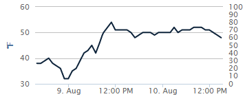
It's hard to define when one season ends and another begins.  But of all 4 seasonal transitions, the summer-to-fall transition is typically the most marked.  A marked transition doesn't happen every year.  Some are more noticeable than others.  The most impressive "autumn arrival" was probably 1959.  Here's a plot of the temperatures for that summer and fall in Spokane:


On September 12, the mercury reached 90F in Spokane.  A cold front moved in, dropping the temperature to 83F on the 13th, 65F on the 14th, and only 51F on the 15th.  But what's most impressive is that after that, the temperature never warmed above 67F for the rest of the autumn.  In other words, Spokane said good bye to the 90s, 80s, and 70s all with one cold front.

At this point we're not expecting a dramatic repeat of that event for 2015.  Spokane averages one day in the 90s in September and 7 days in the 80s.  The record is 10 days in the 90s, back in 1938.  And no, Spokane has never hit 100F in September.

Looking at the warmest 8 summers (based on June, July, and August average temperatures), only one (1958) had a normal September.  The other 7 were all much warmer than normal in September.  

Year Jun Jul Aug Sep
1922 +7.6 +3.2 +2.2 +3.1
1938 +4.5 +5.0 -0.9 +8.2
1940 +6.0 +2.8 +1.9 +5.1
1958 +3.3 +3.0 +4.9 -0.9
1967 +1.2 +0.6 +5.7 +5.7
1998 +0.2 +5.3 +3.0 +5.5
2013 -0.6 +3.9 +3.5 +3.4
2014 -0.6 +5.7 +3.5 +3.5
2015 +9.1 +4.2 +4.2 ???

The folks at the Climate Prediction Center are also favoring a warm and dry September.  Here's the outlook they produced today:


It calls for below-normal precipitation with above-normal temperatures for the month of September.

We typically look at a model called the GFS for forecasts of the weather for the next 7-14 days.  But when we want to look farther into the future, we look at the CFS (Climate Forecast System).  So let's see what it says for September.  First, we'll look at the CFS that was run back on August 10th.

The yellow and orange colors indicate areas where the model thinks temperatures will be above normal in September.  Large area of abnormal warmth over Alaska and Canada, spreading into most of the western US.

Now let's see the CFS from August 20th:


Notice the change.  The model still expects warmth in the West, just not nearly as strong or widespread.

Now here's the latest run of the model, which was fed the data from August 20-30:

We're back to a large area of abnormal warmth over Alaska and Canada, but only a minor area in the northern Rockies.  

The folks at CPC look at this (and a lot of other data) and concluded a warm September for the West.  So don't put away your summer clothes just yet.


Thursday, August 27, 2015

Strong Cold Front on Saturday

You've probably already heard about the change in the weather for this weekend.  Yet another strong summer front will be moving through the Pacific NW.  And yes, it will bring the potential for rain to the area.  Unfortunately, it doesn't look like much for our side of the Cascades.  Let's take a look at 4 models forecast of 24 hour rainfall for Saturday and Saturday night.  First, here's the GFS

GFS forecast of 24 hour precipitation ending 5am Sunday 30 Aug

The GFS shows the majority of the rain falling over western WA and into BC.  This would bring rain to the Cascade fires, but not as much to the rest of the fires in the Inland Northwest.  Here's the NAM forecast:

NAM forecast of 24 hour precipitation ending 5am Sunday 30 Aug
The NAM paints a similar picture.  But you'll notice more rain that is forecast east of the Cascades near Omak.  This would obviously be great new for the Okanogan Complex and North Star fire.  It's also a bit wetter in the Idaho Panhandle, which would be equally good news.  Now let's look at the Canadian forecast:
GEM forecast of 24 hour precipitation ending 5am Sunday 30 Aug

The Canadian GEM model has been consistently the driest for the Inland NW. This would bring less than 0.10" of rain to the fires.  And one last model to look at:
Forecast of 24 hour precipitation ending 5am Sunday 30 Aug

Similar to the other models.  Heavy rain in western Washington and the Cascades, much less in eastern Washington.

But the bigger story will be the wind.  This storm will be similar to the system we had 2 weeks ago on August 14th.  Here's the current wind forecast:

These are sustained winds, and will be 30-40 mph in much of the Basin, Palouse, and Spokane area.  And here's the forecast wind gust:

Wind gusts of 45 to 55 mph.  This is a strong front.  The winds might actually subside a bit in the afternoon after the front moves through the area.

These kind of winds will cause more blowing dust, similar to August 14th.  Here's what the satellite looked like on that day:

MODIS satellite image showing wild fire smoke and blowing dust on 14 August
The blowing dust in the light brown streaks in the middle of the image.  This event closed down Interstate 90 and Highway 395.  Here's some images from the metroforensics blog:


The wind may also cause problems with the numerous wild fires in our area.  Here's a map showing the active fires that are currently burning.  


Wildfires in the Inland NW 27 August

The cold front will move through the region in the morning with very strong winds.  These winds could cause wild fires to spread quickly.  Eventually the atmosphere will become moister as the temperature falls and moisture arrives.  This could help the fire situation.  The window between the frontal passage and the moisture arrival will hopefully be short, keeping fire danger to a minimum.  But if there are several hours in that window, some of the fires could make significant runs to the north and east.

Monday, August 10, 2015

Potential for Severe Weather this week

As we talked about in our previous blog, the weather pattern is setting up for a potential severe weather event on Thursday, August 13th.  Before we get there, there is a potential for thunderstorms today through Wednesday.  Here's the current weather pattern:

GFS 500mb heights, winds, and Humidity (green shading) valid 11am PDT Monday 10 Aug


The low off the Washington coast will slowly creep south along the coast over the next couple of days.  Remember, winds go counter-clockwise around low pressure in the Northern Hemisphere.  That means to the east of the low, the wind blows from south to north.  This "southerly" wind will bring moisture up from the sub-tropics.  We've already seen our dew points rise over the past couple of days.  

Dew point at Spokane August 9 and 10

Note that the dew point has climbed from the mid 30s two days ago to around 50.  That trend will continue for the next few days. So we will have moisture.  The hot temperatures will provide the instability. That combination will produce thunderstorms.    Here's a forecast of radar reflectivity from the HRRR model valid later this afternoon:


The HRRR expects thunderstorms from northeast Oregon and central Idaho to move into the Inland Northwest.  Some of these could produce gusty winds and blowing dust.

While these storms could be strong, they are lacking one of the ingredients for a "big" event:  lift.  The low offshore is too far away to contribute much lift.  And as it continues to drift south, it will be even farther away from us.  So the storms for the next three days will have to rely on moisture and instability alone.

But on Thursday, that all changes.  The low will begin to "eject" to the northeast.  This is a common pattern.  The tough part of the forecast is the exact track and timing of the low.  Here's the current forecast from the GFS model:


Yes, it looks nearly identical to today.  The difference is that at this point the low moving to the northeast.  This is a classic pattern for severe weather in the Inland Northwest, and it's similar to some of the bigger events we had in 2014.  That's not to say we're going to see a repeat of a 2014 event.  But the potential is there for strong and widespread storms.  Here's the NAM and GFS model forecasts of precipitation for the 5pm-11pm time frame Thursday evening.


NAM (upper) and GFS (lower) forecast of 500mb heights (thin lines) and precipitation (green shading) for 5-11pm PDT Thursday evening.


First, you can see a difference in the predicted location of the low.  The NAM has it over southwest Washington, while the GFS is slower with the low offshore still.  But both models show convective precipitation over much of eastern Washington and the Idaho Panhandle.    But the ECMWF (not shown) is even farther south with the position of the low, and so it has even less convection. 

Here's the forecast CAPE (atmospheric instability) from the NAM and GFS:
NAM Forecast CAPE Thursday 2pm

GFS Forecast CAPE Thursday 5pm


Both models show plenty of instability, around 1500 J/kg, which is plenty for strong thunderstorms here.  As you can see, the best instability looks like it will be over the northern and eastern mountains.  Details like this could easily change over the next couple of days so stay tuned as we get a better idea of how this event will pan out.  If the ECMWF is right, it could be a non-event, as the low would cross over us at night.  


Saturday, August 8, 2015

Roller Coaster Weather

You've probably heard the old adage "If you don't like the weather, just wait a little while and it will change."  While that saying is undoubtedly over-used, this week it will be true.  The cause of this roller-coaster weather will be a large low pressure system that's currently off the BC coast.  Here's the 500mb pressure map Saturday morning:


You can see the low just west of British Columbia.  During the first half of this week, the low will very slowly move down the coast, reaching Northern California by Wednesday:


This will do a couple of things.  First, it allows the very hot ridge of high pressure that's currently over Texas to amplify over the center of the U.S.  The Inland Northwest will be on the western edge of this ridge, but still close enough to feel its effects.  Our temperatures are going to jump up in a major way, and quickly.  After are mild weekend, temperatures will warm about 8 degrees on Monday, and then another 5 on Tuesday and Wednesday.  The result is a very hot middle of the week.  Here's the current forecast:


The other thing this pattern will bring is thunderstorms.  The area between the off-shore low and the mid-US high will see persistent flow from the south.  This brings moisture with it, which will bring the potential for thunderstorms.  Initially, these will be rather isolated and won't have much rain with them.  Any lightning from them will have the potential to start new wildfires.  

By Thursday, the low will stop moving south and begin to "eject" back into the jet stream to our north.  As it does so, it will track directly over the Pacific NW.  Here's the forecast for Thursday afternoon:


This scenario is nearly a "classic" pattern for strong thunderstorms in our area.  The ingredients we look for are: 

  • Instability: The 3-day hot spell will do a good job of destabilizing the atmosphere.
  • Moisture: The southerly flow will bring up moisture from the south.
  • Lift: The strong low will supply the lift as it moves over our area.
The exact details are still too far out to get into.  So as we get closer to the potential event, we'll likely update this blog.  Suffice to say, if everything comes together just right, we could be looking at a significant thunderstorm event on Thursday afternoon/evening.

In its wake, the low will bring much cooler temperatures.  Here's the forecast high temperatures for Friday:


So, enjoy the roller-coaster ride this week.