North Spokane got hit by a strong
thunderstorm that produced an excessive amount of rain over a short period of
45 minutes requiring a Flash Flood Warning to be put out for the Indian Trail
neighborhood. The thunderstorm started to build around 2:30 pm and continued to
build over the next half hour before dissipating. There were many reports of
rain from as little as .69" in Spokane Valley to 2.24" in North
Central Spokane with possible higher amounts that were not recorded. A gust front formed as a result of the quick development of the thunderstorm and we also noted a temperature drop of 10˚ over the Spokane area within an hour.
Storm Totals
Below is an image of the 24 Hour Rainfall Totals. The shaded areas below are estimates generated from the radar–most of the values within the shaded areas were verified by storm spotters in the area. These values may include light rainfall data that may have occurred before and after the initial storm, but it gives a rough estimate of where the majority of the rainfall took place.


The last radar image that showed the storm was at 3:15 pm. By this time we can tell that the storm was over and there was no storm building up behind it. There was little red visible on the map indicating the worst of the rain was gone.

This last image shows where the location of possible hail would have fallen in the storm. The small pink area shows anything that depicts on the radar over 60 dBZ which indicates extreme rain or moderate hail.

Storm Motion
Along with the rain, there was also a gust front that was produced from the downburst that occurred. This map shows the direction the wind was moving. We can see a definite line along Highway 291 where there is green along one side and red on the other. The green shows the wind that was moving toward the radar which is labeled KOTX. The red shows the wind that was moving away from the radar. As time moved along, we can see that the gust front on the west side of the storm was moving towards the radar and away from the storm.


Photos from around the Area
There were many photos from the public on social media and those photos have been placed on a map in the link below. There are photos from directly under the storm as well as some of the other storms that were around the area.
Radar Image
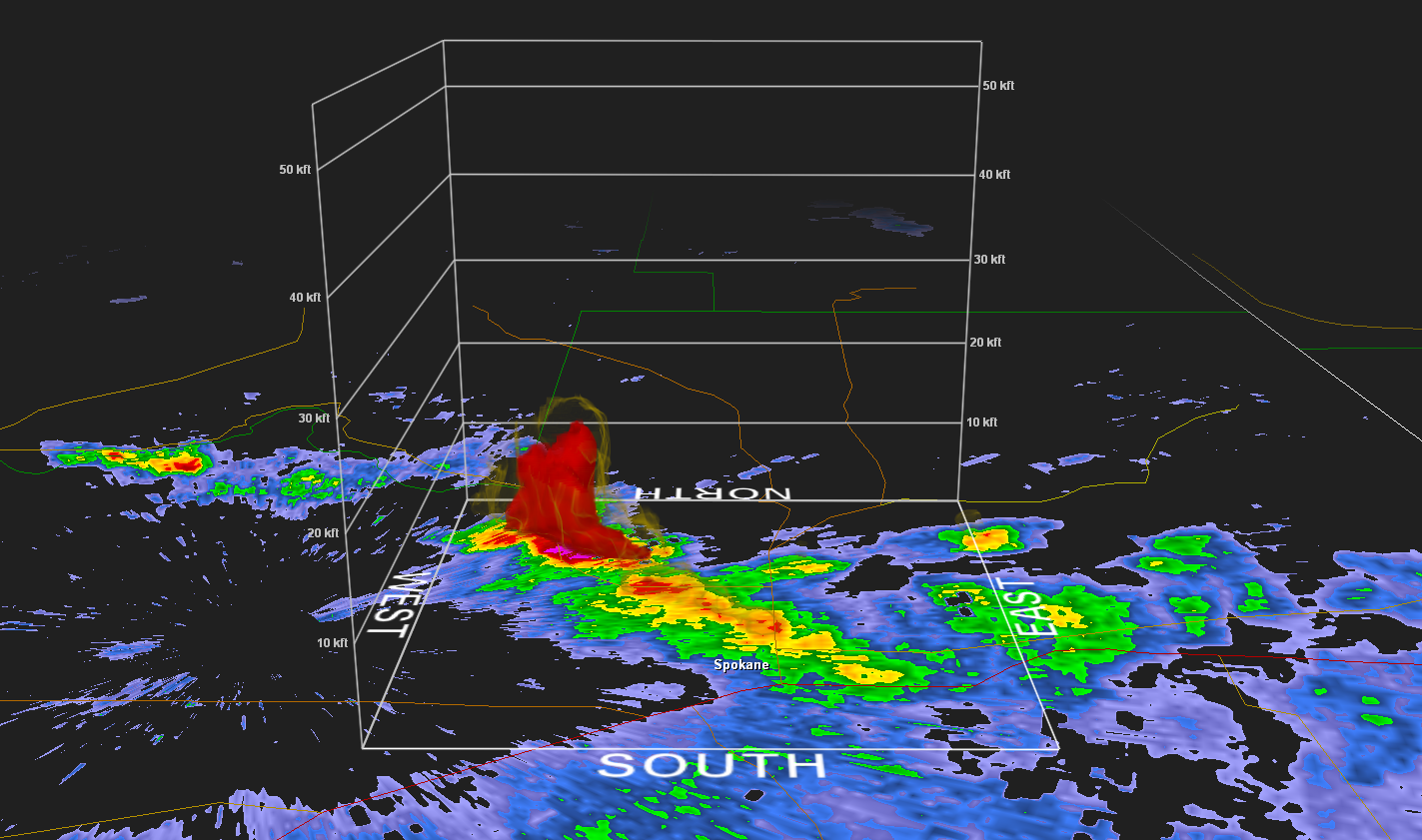
There are 3D radar images of
the storm below that started at 2:34 pm and continue until 3:15
pm. The radar indicated where the strongest rainfall was and also where hail
could possibly have fallen. There is some yellow that is visible on the map to
help show the shape of the storm. The 3D imagery of the map focuses on the red
portion of the radar and less on the yellow and green (the lower dBZ). The red
indicates any rain that was over 50 dBZ which is considered heavy rain.
We can see how the storm built along with the heavy rain in a vertical motion.
We can see in this first imagery that the storm was starting to build above the Indian Trail area in North Spokane but showed no indication of possible heavy rainfall. However, there is a hint of yellow on the map that showed that there could possibly be moderate rainfall.

Radar image at 2:34 pm PDT
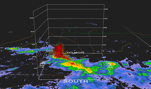
After 12 minutes passed, we can see that the storm was vertically stacked with heavy rain up to 20kft which is roughly 3.7 miles. The storm over Indian Trail was stronger than the rest of the storms in the area due to the fact that it was towering over the rest and it also was recorded with a stronger dBZ.

Radar image at 2:46 pm PDT
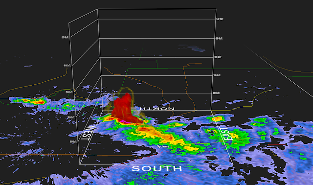
The heavy rain continued even at 2:52 pm, as the storm maintained heights upwards of 20kft showing no relief of the heavy rainfall. The storm that was to the south east of the strongest storm had not gained a lot of strength.
Radar image at 2:52 pm PDT
At 3:03 we can see that the storm intensity had greatly decreased from what it was at its heaviest and was only reaching heights of 8kft (roughly 1.5 miles). Within a matter of 17 minutes, the storm had lost most of the heavy rain that was contained within it.

Radar image at 3:03 pm PDT
The last radar image that showed the storm was at 3:15 pm. By this time we can tell that the storm was over and there was no storm building up behind it. There was little red visible on the map indicating the worst of the rain was gone.

Radar image at 3:15 pm PDT
This last image shows where the location of possible hail would have fallen in the storm. The small pink area shows anything that depicts on the radar over 60 dBZ which indicates extreme rain or moderate hail.

Radar image at 2:46 pm PDT
Storm Motion
Along with the rain, there was also a gust front that was produced from the downburst that occurred. This map shows the direction the wind was moving. We can see a definite line along Highway 291 where there is green along one side and red on the other. The green shows the wind that was moving toward the radar which is labeled KOTX. The red shows the wind that was moving away from the radar. As time moved along, we can see that the gust front on the west side of the storm was moving towards the radar and away from the storm.

Wind Direction at 3:03 pm PDT

Wind Direction at 3:15 pm PDT