Many woke up to a surprise snowstorm in the Wenatchee area this morning, catching even us meteorologists by surprise. Scenes like the ones below were common around Wenatchee.
 |
| Courtesy WSDOT |
The April snowfall record for the Wenatchee Water plant was only 0.5", so seeing reports like the one's below is mighty impressive!
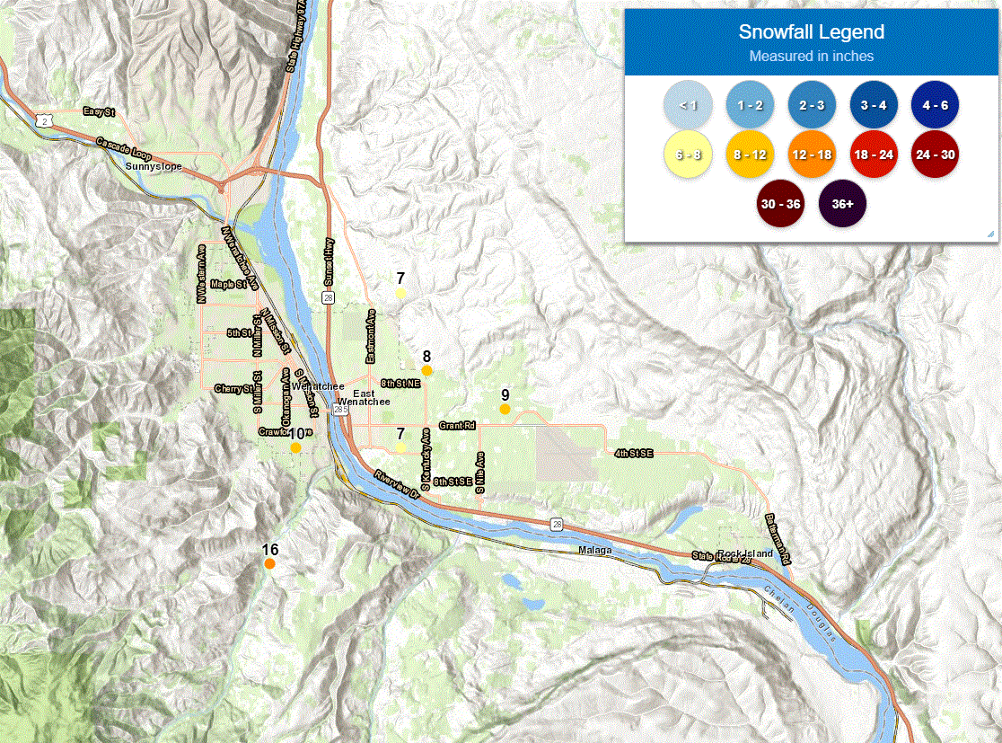 |
| Snow reports received Thursday morning, April 14th, 2022 around the Wenatchee area |
Wow! Reports ranging from 7-10" in town with one report of 16" south of town.
Was this expected? Well here was the forecast for the Wenatchee area issued the afternoon before.

There was a cold and unstable low pressure system near the Wenatchee area Thursday morning. Here is one model showing a large pool of cold air aloft (purple and pink shading) over Washington and North Idaho. With the center of low just to the south of Wenatchee, there were no downslope westerly winds to contend with which is more common for Wenatchee.

But just cold air isn't enough to create snow, rising motion in the atmosphere is needed. Below is a satellite loop from 5 AM- 8 AM PDT this morning showing cooling clouds tops associated with the upward motion of the atmosphere around the Wenatchee area.
 |
| GOES 17 Infrared Satellite Loop 5 AM - 8 AM PDT April 14th, 2022 |
This was a small scale feature that models often have a hard time capturing ahead of time. Often the focus of heavier showers is over a small area. What did the models have to say before the event? Here are five of the higher resolution models that were initialized at 5 AM the previous morning (Wednesday).
As you'll see they all indicated a small feature, but most solutions had the band of showers south of Wenatchee (located at red dot on each image).
 |
| HRRR forecast of composite radar reflectivity issued 5 AM Wednesday valid 7 AM Thursday. |
 |
| NSSL forecast of composite radar reflectivity issued 5 AM Wednesday valid 7 AM Thursday. |
 |
| ARW model forecast of composite radar reflectivity issued 5 AM Wednesday valid 7 AM Thursday. |
 |
| FV3 model forecast of composite radar reflectivity issued 5 AM Wednesday valid 7 AM Thursday. |
 |
| NAM Nest forecast of composite radar reflectivity issued 5 AM Wednesday valid 7 AM Thursday. |
And another model showing 24 hour snow accumulation from the UW WRF-GFS shows accumulations south of Wenatchee.
 |
| UW WRF-GFS forecast of 24 hour snowfall issued 5 AM WED valid 5 PM WED-5 PM THU. |
Based on the above, a 20% chance of snow doesn't seem like too bad of a forecast.
How about some of the ensemble forecasts? The 5 AM Wednesday UW Ensemble plumes of snow forecasts weren't too excited about heavy amounts of snow in Wenatchee but there were a few solutions going for more than 1".
 |
| UW 4-km Ensemble plumes for Total Snowfall initialized 5 AM Wednesday - Wenatchee |
Notice that most model projects solutions have less than 1". But what a change with the next set of model forecasts that came in just 12 hours later...with a mean of 5" with several members showing 7" or more.
 |
| UW 4-km Ensemble plumes for Total Snowfall initialized 5 PM Wednesday - Wenatchee |
This is one scenario where forecasts can change so quickly. Small but unstable spring time low pressure systems can create localized areas of heavy snow.
This was a much different type of storm, compared to the record snow storm that hit Wenatchee earlier this year. A blog discussing this setup prior to the snow arrival can be found here. This has been the year for record Wenatchee snow events!
We still have this cold low sitting over the region. Where will the next local snow storm strike? We will be keeping a close eye on things, and for the latest forecasts please visit weather.gov/spokane