Wednesday, December 18, 2019

White Christmas 2019

We're only a week away from Christmas, so the natural question is "Will it be a White Christmas?"  And as always, the answer is "It depends on where you live."  Just to remind folks, here's the climatological odds of a White Christmas in the Inland Northwest:


But this is based on the Christmases between 1981 and 2010.  What about this year?

As of 17 December 2019, here's where the snow currently resides:

NOHRSC Snow Depth December 17th, 2019
This doesn't look too promising.  Most of the cities/towns are either snowless, or have just a patchy trace of snow.  Is there any hope on the horizon?  Turns out that there is, but it may not deliver what we're hoping for.

Snow outlook this week

We are about to enter a wet pattern.  Initially most areas will get snow, but a warm up will result in snow changing to rain except in the mountains and possibly Methow Valley where heavy snow accumulations are expected.  This is especially true in the Cascades where some peaks will see snow totals in excess of 4 feet!  The Upper Methow Valley and Lake Wenatchee area are forecast to receive 1-2 feet!

NWS Forecast issued Wednesday afternoon for forecast snow Thursday-Saturday (Dec 19-21)

 For the majority of the valleys, these amounts reflect Thursday totals as temperature warm on Friday.


 Warming up

A significant warm up is expected, as noted by this ensemble temperature forecast for Spokane.

12z Dec 18th GEFS forecast of 2-m Temperature (F) for KGEG (Spokane Airport)
Note temperatures rise significantly on the 20th (Friday) and don't fall below freezing until the 22nd or 23rd.  And it's not just Spokane warming up, here are the projected temperatures for Friday. 

NWS Max Temperature Forecast issued Wednesday afternoon valid Friday, December 20th, 2019

Nearly all valleys in the 40s, with mid 50s around the Tri-Cities and Walla Walla areas.  The exception in the Cascades where snow melt will be minimal, with areas of heavy wet snow persisting.   The warm temperatures are expected to melt much of the lower elevation snow.

So what is the cause of this pattern.  A mild southwesterly flow ushering in warmer air.  Below is  one model prediction for Friday and Saturday showing a deep fetch of mild but moist air over the region.

12z/Dec 18th GFS Forecast of 500mb heights and 700-500mb RH valid 4 AM PST Friday, December 20th


12z/Dec 18th GFS Forecast of 500mb heights and 700-500mb RH valid 4 AM PST Saturday, December 21st

So many areas will lose their snow by the end of the week.  The mountains, Cascade valleys, the Republic area, and areas near the Canadian border stand the best chance for hanging onto some snow. 


Christmas Day Outlook

So, you be asking what about Christmas Day itself?  Well here is the projected weather pattern

12z/Dec 18th GEFS forecast of 500mb heights and winds for Christmas Day

This shows a split flow pattern with the jet stream well to our north across northern British Columbia, with a stronger branch of the jet dropping down into Mexico.  This supports dry weather for our neck of the woods.  Christmas Eve looks dry as well.   Now as of this writing this is a 7 day forecast which is subject to change.  There are just a few model runs that still give a little hope of light snow, but at this point a dry Christmas is expected. 

A White Christmas is a good bet for the mountains especially the Cascades as well as the Cascade valleys.  Some northern valley locations may hang onto some snow as well.  Elsewhere a White Christmas is unlikely. 

Sunday, November 24, 2019

Very windy Thanksgiving Eve

A very windy Thanksgiving Eve is expected for much of Central and Eastern Washington and the Idaho Panhandle.  Last week some model solutions were further north with this storm giving the Inland NW a better threat for snow by Thanksgiving.  While snow is still expected for some areas (mainly Cascades, Blue Mountains, Camas Prairie, Central Panhandle Mountains) winds look the bigger story as the storm taking a southward shift.

Here is an early look at potential wind gusts Wednesday as of our Sunday morning forecast.

NWS forecast issued Sunday morning - Peak wind gusts Wednesday, November 27th, 2019

And with these winds we could see some impacts across the region.


Thanksgiving Eve is one of the busiest travel days of the year.  Depending on which roads you're traveling you may experience strong tailwinds, headwinds, crosswinds, or a combination of all. Please monitor the latest forecasts and travel safe.
  
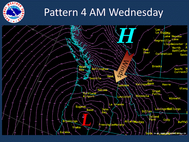
This is an interesting storm.  The maps that follow are forecast maps of Mean Sea Level Pressure (MSLP).  The two most important things to know when looking at these maps are

1) Winds blow from high pressure (H) to low pressure (L)

2) The closer the lines are too each other the stronger the wind.

Let's begin with 4 AM Tuesday.

00z GFS forecast of MSLP valid 4 AM PST Tuesday, November 26th, 2019

A weak low off the northern Oregon coast.  Note the large spacing of the pressure lines (pink) over Washington and north Idaho meaning weak winds.  Nothing of much interest yet.

00z GFS forecast of MSLP valid 4 PM PST Tuesday, November 26th, 2019

Whoa!  The storm has intensified greatly in just 12 hours from 1006 mb to around 973 mb.  Note the northeast winds beginning to increase over our region as pressure gradients begin to tighten with the approaching storm.

00z GFS forecast of MSLP valid 4 AM PST Wednesday, November 27th, 2019

Wednesday is when winds increase even further.  Thankfully, the storm over Oregon weakens, but the squeeze is on between high pressure to our north, and the Oregon storm to our south.   Note the tight packing of the pressure gradient.  The graphic above was from one model solution (GFS).  Other model solutions such as the European and Canadian show a similar depiction. 

With the strong northeast winds will come colder air, here are the forecast highs for Thanksgiving Day.

NWS Forecast issued Sunday morning of high temperatures Thanksgiving Day
And the cold will likely stick around for awhile.  Here are the 6-10 and 8-14 day temperature outlooks from the Climate Prediction Center.

CPC 6-10 day temperature outlook issued Nov 23rd valid Nov 29-Dec 3rd, 2019

CPC 8-14 day temperature outlook issued Nov 23rd valid Dec 1st-7th, 2019

Although currently the cold pattern looks like a dry one with latest CPC 6-10 outlook favoring drier than normal.

CPC 6-10 day precipitation outlook issued Nov 23rd valid Nov 29-Dec 3rd, 2019

But let's not forget what's bringing us the colder weather.  And that is strong northeast winds on Wednesday.  Those with Thanksgiving Eve travel plans should monitor the latest forecasts.  And if you are traveling to other states especially south or east, snow could impact your travel.  For the latest forecasts, watches, warnings, and advisories visit weather.gov or for local travel plans across Central and Eastern Washington and north Idaho weather.gov/spokane

Friday, November 15, 2019

The persistent ridge - A look back and forward

Curious what this winter will bring?  In past years we have written a blog about the winter outlook in late September or October, but this winter prediction has been a challenging one.  Let's begin with the weather pattern since last February.

500mb height anomalies for selected time periods since February 2019
 
Lots of colors to look at.  The screaming message has been the persistent ridge in the eastern Pacific.  It has had varying magnitudes and placement but has been there in some way, shape, or form since February.  Last February and March it was very amplified bringing cold and snowy weather to our region.

Over the summer the ridge allowed weather systems to drop down into the area with the # of 90 degree days much lower compared to the past five years.


And then this past October was noteworthy with the coldest October for many across the Inland NW.


Now it's November, and the very amplified ridge has given us a very dry start to the month as well as much of the western US.


It does look like a weather system will track into the area early next week (Nov 17-19th) time frame bringing rain and high mountain snow.  Here is the Nov 18th pattern showing a low off the WA/OR coast with the jet stream over the area.

12z Canadian model forecast of 500mb heights and 250mb winds (image) valid 4 PM PST Nov 18th, 2019

Don't expect this to be a long lasting change.  The ridge returns Wednesday and will probably last through the rest of the week.

12z Canadian model forecast of 500mb heights and 250mb winds (image) valid 4 PM PST Nov 20th, 2019

So the persistent ridge - what does it mean for this winter?  We are looking at a neutral year (neither El Nino or La Nina), which typically brings a lot of variability for our winter weather.  But on average, this is the pattern that sets up

Typical weather pattern for ENSO-Neutral years

Typically active weather sets up as a Pacific Jet Stream takes aim at the area.  With this said, it's interesting that several climate models want to give us a wet December.  Here is what the average of the models (NMME forecast) shows.

NMME model forecast of precipitation anomalies Dec 2019
But how much confidence can we have in this climate model projection?  Unfortunately, the skill score map is very low (want to see greens and purple over our area) meaning forecasting precipitation anomalies just one month into the future this time of year is hard for the models to depict accurately.

NMME skill score of precipitation anomalies initialized in November for December
So, what will this winter bring? Given the neutral winter a more active pattern setting up is a good possibility.  But when this occurs and how long it lasts carries low confidence given the tendency for high pressure over the eastern Pacific since last February.  As with any winter, short term significant winter events are likely.   Common winter hazards for the Inland NW include snow, ice, winds, and local flooding. 

Wednesday, October 30, 2019

More records - this time coldest October

After record September snow for some cities, we have more monthly records to talk about.  This time it's the cold October.   Here is a look at the October temperature anomalies thus far which shows about 6 degrees below normal for the month.

Mean daily temperature anomaly Oct 1-29th, 2019
Just six degrees below normal may not sound record worthy, but typically colder weather in October doesn't last for prolonged stretches making this month noteworthy.

Why the cold?  Let's begin with the weather pattern we've been in this month.

500mb height anomalies Oct 1st-28th, 2019

Strong high pressure in the Gulf of Alaska has resulted in prevailing northerly flow across the area allowing for several rounds of cold, Canadian air to invade the region.

Three noteworthy cold intrusions have occurred during the month as noted by this temperature graphic from Spokane.

Spokane Airport observed temperatures, normals, and extremes 


The blue vertical bars are observed temperatures.  The top brown line is normal high temperature and bottom brown line normal low temperature.  Notice the temperature graphic starts towards the end of September when historic September snow was followed by cold temperatures which lingered into the first part of October.  Next on the Oct 8/9th a cold system brought a band of heavy wet snow and power outages to portions of NE Washington and North Idaho with 6" Rathdrum and Hayden and 3" at the Spokane Airport.  And now the cold snap to finish out the month following the strong arctic front passage on the 28th where the palouse was especially hit hard with snow and wind.

Several October temperature records have already been broken including Sandpoint, Ritzville, Davenport, Nezperce, and Winthrop.  Soon more locations will likely be added to this list given our cold weather to finish out the month including Spokane, Moscow, and Ephrata.

October temperature records already or likely to be broken

Note these temperature aren't final yet for the month and include average temperature for data received thus far.  But nonetheless, more records are expected to be broken.

The graphic above summarizes the records.  If you are interested in seeing the details of the records broken or likely to be soon broken, read on below.  Keep in mind the numbers below are so far.  For example for Spokane the average temperature through Oct 29th was 43.1 degrees.  However the average temperature only needs to drop to 42.8 degrees to tie the record and 42.7 to break the record.  Given the cold temperatures on the 30th and 31st, the record is expected to be broken.

Spokane


Spokane, WA top 5 coldest Octobers

Moscow


Moscow, ID top 5 coldest Octobers

Ephrata


Ephrata, WA top 5 coldest Octobers

Sandpoint, ID


Sandpoint, ID top 5 coldest Octobers

Ritzville, WA

Ritzville, WA top 5 coldest Octobers

Davenport, WA


Davenport, WA top 5 coldest Octobers

Nezperce, ID


Nezperce, ID top 5 coldest Octobers

Winthrop, WA


Winthrop, WA top 5 coldest Octobers

Sunday, October 27, 2019

Arctic front passage Monday PM

Yet another cold weather system will impact the Inland NW this week.  A strong arctic front passage Monday evening will drop temperatures significantly for mid week.  We will take a brief look at the weather expected with this front and finish with why this is all happening.

Windy conditions will be the main story.  Here are the forecast sustained winds Monday evening as the front passes through.

NWS Forecast issued Sunday afternoon of sustained winds 8 PM Monday, October 28th
Here are the forecast wind gusts.  Orange shading ranges anywhere from 35-45 MPH.


NWS Forecast issued Sunday afternoon of wind gusts Monday afternoon and evening


We are also expecting the potential for a brief period of light snow with the front across NE Washington into the Idaho Panhandle.

NWS Forecast issued Sunday afternoon of potential snowfall Monday afternoon - Tuesday evening


The main threat of accumulation will be up in the mountains of the Idaho Panhandle where 1-2" is possible.  But a dusting of valley snow is possible across NE Washington and North Idaho as well.

The winds will usher in cold wind chills for Tuesday morning.


Forecast wind chills Monday night into early Tuesday morning

Temperatures will begin to moderate for the middle to end of this week but still remain below normal.

Why all this cold weather? 

Anomalous high pressure off our coast sending cold systems into our region from the north.

500mb height anomaly Oct 1-25th, 2019

The cold weather to end October could result in some cities threatening records for the coldest October.  Stay tuned!

Thursday, September 26, 2019

Rare September storm

With lots of media coverage about the upcoming storm, we will take a look at this rare September event.  Only a few cases since 1900 have set up like this one so early in the season.  This pattern during the winter months is common, but late September is not.  The region will see early season snow in many areas, strong winds, and eventually freezing temperatures.   For the latest NWS forecasts including watches, warnings, and advisories please visit our web page found here

The setup

So why is this happening?  An amplified ridge of high pressure in the Eastern Pacific and a deep cold low over our region according to this model prediction.

12z/Sept 26th GFS forecast of 500mb heights and 250mb winds valid 11 AM PDT Saturday Sep 28th, 2019

The image is the jet stream diving south off the coast into California.

And this low is not in a hurry to move.  Here is a closer look at the storm for Saturday morning.  The image is relative humidity with bright green indicating higher moisture content and thus better chances for precipitation. 


12z/Sept 26th GFS forecast of 500mb heights and 850-500mb relative humidity valid 8 AM PDT Saturday Sep 28th, 2019

And now Sunday morning

12z/Sept 26th GFS forecast of 500mb heights and 850-500mb relative humidity valid 11 AM PDT Sunday Sep 29th, 2019

This low doesn't move much, with bands of precipitation continuing.  Also during this time frame we will have cold continental air pouring into the region.  Winds blow from high pressure to low pressure.  The tighter the lines are together, the stronger the wind.  Note the tight packing over the North Idaho Panhandle especially.

12z/Sept 26th GFS forecast of MSLP valid 8 AM PDT Saturday Sep 28th, 2019

Early season snow

Snow this early in the season is uncommon.  Below is a chart showing snowfall records for the month of September, and the number of days of measurable snow recorded during the entire period of record for the month.  Getting measurable snow in September has either never happened, or only once in the entire climate record for all towns across the area except Priest River with two occurrences.


So where will it snow?  A near certainty in the mountains.  Valleys will depend on elevation.  Here is our forecast issued Thursday afternoon regarding possible snow accumulations through the weekend.


The mountains will see 6+ inches for many locations.  The valleys have the potential for light snow amounts Saturday night into early Sunday on grassy surfaces mainly above 2000-2500 feet and across the North Idaho Panhandle.

Keep in mind ground temperatures are warm this time of year.  This will reduce the threat of snow accumulations on roads during the day with the overnight and early morning hours the most likely period of winter driving conditions in the mountains.  But any heavy bands of snow that set up could result in slushy conditions during the day as well. 

Snow levels will be falling this weekend.  Here are the forecast snow levels Saturday morning.


And now Sunday morning


Does this mean snow in your town?  Knowing your elevation can help when we are talking snow levels.  The tables below show elevations for selected towns and several high elevation highways and passes.


Strong winds

Saturday will have the strongest winds.  Here is the peak wind gusts forecast for Saturday


The strongest winds are expected from Sandpoint to Coeur d'Alene and across parts of the Upper Columbia Basin.  Winds of this magnitude may result in localized downed trees and power outages. These winds this time of year would typically pick up blowing dust across the Columbia Basin but expected precipitation should minimize this threat. The winds will persist Sunday but not as strong.  The winds will make it feel even colder as noted in next section.

Unseasonably cold temperatures

Freezing temperatures will soon be hitting many areas beginning Sunday morning.  Here are the forecast lows for Sunday morning


 But the wind will make it feel colder.  Here are the forecast wind chill values for Sunday morning

Sunday morning wind chill forecast
For those heading out Monday for work or school, here are the forecast low temperatures.

 
Tuesday could be even colder for several towns.


Those with morning plans bundle up!  Freezing temperatures are expected for most while a hard freeze is possible in the colder spots. 

The high temperatures this weekend are noteworthy as well.  Daily records will likely be achieved in many areas beginning Saturday.  Monthly records are also within reach.  Here are the coldest September high temperatures ever recorded.


 Temperatures are expected to moderate towards the middle of next week, but still well below normal with the latest CPC outlooks favoring below normal temperatures and slightly elevated odds of wetter than normal in the Oct 2-6th time frame.


CPC 6-10 day temperature (left) and precipitation (right) outlooks issued Sept 26th, 2019

 This weekend will be a noteworthy September storm.  Get ready for winter like conditions. And if you have travel plans east into Montana, conditions will be even worse, much worse!

NWS Forecast of snowfall issued Thursday afternoon valid Friday night through Monday
For the latest NWS Forecasts for our local area or if you are heading east, go here:

NWS Spokane: link
NWS Missoula: link
NWS Great Falls: link
NWS Billings: link
NWS Glasgow: link