Sunday, December 29, 2013

Another kind of White Weather

This year, snow has been hard to come by in the Inland NW.  But in our area, there's another way the weather can paint the landscape white.  While some may refer to it as frost, technically it's rime.  What's the difference?  Actually it's rather simple.  Frost comes from water vapor (the gas form of water), while rime comes from water droplets (i.e. fog).  So if you get a dusting of white on the lawn or trees during a clear night, it's frost.  But if it forms during a foggy night, it's rime.

You may be asking yourself why don't the droplets freeze if the air temperature is below freezing?  The reasons are pretty technical, having to do with nucleation and latent heating, so we won't go into it here.  But suffice to say, if the air temperature is between 0°C and -15°C (between 32°F and 5°F), the cloud (or fog) will be made up entirely of liquid droplets.  We call these super-cooled liquid water. If the temperature is colder than that, ice crystals start to form.

A website from CalTech has an excellent overview of frost vs rime, along with great pictures the two.  Visit it at: http://www.its.caltech.edu/~atomic/snowcrystals/frost/frost.htm

For the Inland Northwest, we often experience extended periods of dense fog in the winters which lead to heavy accumulations of rime on trees and other objects.  One event in January 2009 created some beautiful rime on the trees at our office west of Spokane.


This next image shows how the rime crystals actually formed in a preferential direction, due to the wind.  While you might guess that the light wind was blowing left to right, you'd be wrong.  The wind was blowing lightly (1-3 mph) from the right to left, and the crystals grew into the wind.


While this rime does make for some neat pictures, it also can cause problems.  During this 2009 event, the rime accumulated power lines along Highway 2 west of Spokane.  This rime accumulation actually led to power outages for many customers in this area. Here's a picture taken by the Avista repair crews.  The weight of the rime caused the power lines to lower almost to the ground.


And here's the rime accumulation on a power substation.


Lastly, anyone who skis our area mountains probably has seen some even more impressive rime on the trees.  Here's a couple of examples from Mount Spokane.


Thursday, December 19, 2013

Update on the Potential for a White Christmas

In our last blog, we stated that things weren't looking real great for a White Christmas in the Inland Northwest this year.  As expected, the weak system on Wednesday didn't amount to much for most locations.  Is there any hope for the next system on Friday?  Actually, yes!  Let's look at the ingredients.

First, we need cold air.  While Wednesday's wimpy system didn't bring much precipitation, it did bring in some good, cold air.  While it didn't feel real cold this morning, we will be colder tonight.  Here's our forecast low temperatures for Friday morning:


And we will stay cold on Friday.  Here's the forecast high temperatures:


The next thing we need is moisture.  As we said in our previous blog, storms coming at us from the northwest (what we call Northwest flow) typically don't have much moisture in them.  This isn't a good weather flow pattern for our area.  But this storm is one of those exceptions to the rule.  The image below shows the moisture plume in the eastern Pacific.  Without getting into a lot of detail (we'll save it for a future blog), the shading represents moisture, and the black arrows are wind direction.  This image shows moisture coming up from near the Hawaiian Islands, over the ridge of high pressure, and pointing into the Pacific Northwest.


So this time we will have a good fetch of moisture to work with.  The computer models are in decent agreement, which always helps our confidence in the forecast.  We'll show the GFS model.  Here's the precipitation forecast by 4am Friday:


You can see that while there's some lingering showers in the southern Panhandle, the main precipitation from Gulf of Alaska system will just be reaching the Cascades at this time.  The snow will then spread across eastern Washington and north Idaho during the morning hours.  So the Friday morning commute shouldn't be impacted for the most part.  Here's the total precipitation forecast by the GFS by 10pm Friday evening:


You see plenty of precipitation over the Cascades, and then another blob over southeast Washington.  This area (Pullman, Moscow, Lewiston, Grangeville) does well in these northwest flow events, and they will see the most snow from this event.  Farther north (e.g. Spokane) will see lesser amounts, but still a good shot of precipitation.  You can see that the GFS gives very little precipitation to central Washington, which is typical.  This is the Cascade precipitation shadow.   

All of this precipitation will fall in the form of snow.  It should be a dry snow, and road surfaces will be cold, so we don't expect much ice on the roads;  packed power should be the predominate road condition for your drive home on Friday afternoon.  But it will probably be snowing fairly hard during the evening rush hour. 

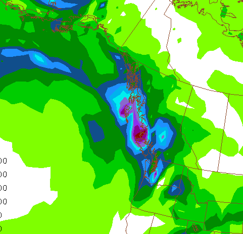
Here's an image showing how much snow we expect from this storm:


Our forecast calls for about 3" in Spokane, while Pullman/Moscow could see around 7".  But just about everybody gets some snow.  Wenatchee and Moses Lake should get less than an inch.

There are some models that are painting a slightly different picture.  The WRF model run at the University of Washington is shown below:


This model still has the heaviest amounts of snow in the Cascades and southeast Washington area.  But it has a band of heavier snow from Omak to Pullman.  This model would give Grand Coulee about 7".  While this isn't impossible, it's not considered very likely.   We shall see.  Note that there is also snow forecast for the Puget Sound area, especially north of Sea-Tac.

But then the question is:  can we keep this snow for 4 more days in order to have a White Christmas?  Obviously, the more snow we get on Friday, the better our chances will be to keep it.  But will the weather cooperate?

The forecast does show warmer temperatures arriving for Sunday and Monday, but then cooling back down for Christmas Eve and Day.  Spokane is forecast to reach the upper 30s, with many locations south of I-90 warming into the lower 40s on Monday. 

We might also see a little rain on Monday. But it's not the rain and the warmth.  You can have a day of 40 degrees and some rain and only lose an inch or so of snow.  But we'll also have a warm, moist wind from the southwest on Monday.  This kind of weather can eat snow in a hurry.   If you have anything left by Tuesday morning, it should survive until Christmas.


Saturday, December 14, 2013

Odds of a White Christmas

With Christmas only 11 days away, it's time to start thinking about the chances for a White Christmas.  First, let's look at climatology.  In other words, what are the chances of a White Christmas in any year, based on what has happened in the past.  The National Climatic Data Center produced a nice map of the 48 states earlier this week.  It showed the climatology of at least 1" of snow on the ground on December 25th.   Below is the map, or if you want to read their article, you can find it at: http://www.climate.gov/news-features/featured-images/what-are-your-chances-white-christmas


Here's a zoomed image of the Pacific Northwest:


While the mountains are almost assured of a White Christmas, the valleys (where most of us live) have much lower odds.  Here's a table of the probabilities for selected cities in the Inland Northwest:


Let's take at the analysis of snow cover from the National Operational Hydrologic Remote Sensing Center (NOHRSC):


If you see a shade of green, that's bad (if you want a White Christmas).  The light gray shading (less than 2") isn't much better.  While we're at it, let's refresh our memories of last year.  Here's the NOHRSC image of snow cover last year at this time:


A much better coverage of snow last winter than this year at this time.  Just about everyone had some snow on the ground, and some valleys had more than a foot.

But, there's still 10 days to pick up some snow.  Does the forecast offer any hope?  Here is the jet stream image at 4pm Saturday:


The shading is wind speed.  The wind blows parallel to the solid black lines.  So the jet stream comes off the Asian continent (left side of the image), but half way across the Pacific (center of the image) it is diverted north by a ridge of high pressure over western North America.  This diverts the Pacific storms north of our area into western Canada.  From there, they dive into the midwest US.  This is not a good weather pattern for precipitation in our area. 

Here's the same image, only it's a forecast for next Wednesday afternoon:


Doesn't look much different, does it?  There is a slight difference.  The ridge of high pressure is now over the Gulf of Alaska, giving us a slightly better chance of getting some precipitation.  This is our next best chance of snow. Still, not a great pattern for snow for our area.  And here's the forecast for Christmas Eve:

Again, not a lot of difference.  Still a huge ridge over the West Coast.  Not good for stormy weather.  However, this pattern does leave the potential for another cold arctic air mass to come into our area.  We're not saying that's going to happen, but there is the potential and we'll be keeping an eye on it.

We will see some systems move over this ridge of high pressure and give us a glancing blow.  So there will be some chances for precipitation.  The next chance will be in the middle of next week.  Not a great chance though.  A similar system is forecast to move through on Friday.  And there are potentially a couple more systems before Christmas.  Again, none of these are impressive-looking systems.  But 10 days out is pretty iffy to trust computer forecasts.

So, here's a summary of what we're looking at for the next 10 days:
  • No big snow storms.
  • Best chance for precipitation will be in the southern Idaho Panhandle (e.g. Moscow).
  • Very low chances of precipitation for the Columbia Basin (Wenatchee, Moses Lake, Tri Cities).
  • Near-normal temperatures (lows in the 20s, highs in the 30s) for the next week, but colder weather is possible.


Wednesday, December 11, 2013

Weird Temperatures

  In previous blogs, we've noted how there are a few ingredients that affect temperatures. We're all familiar with the affects of sunshine and its resultant heating. In meteorological terms we like to call this the "diurnal cycle", since it corresponds to the daily sunrise and sunset cycle. Here's a graph of what we're talking about:


Hourly temperature graph for Deer Park, WA. 

This shows the temperature at Deer Park, Washington for an "average" winter day, one that wasn't affected by clouds, precipitation, wind, etc.  With time starting on the left, the temperature warms during the day shortly after sunrise. The temperature then reaches it peak around 3pm after continuous solar heating. The temperature then rapidly plummets after sunset, continuing to cool through the remainder of the night until the sun rises again and the cycle repeats itself. Sunrise and sunset for this time of year are around 730 am and 400 pm. 

On the past few nights, we've seen some temperatures that haven't "behaved" like the average diurnal cycle.  The image below shows Deer Park on the 7th through the 9th.  


Hourly temperatures for Deer Park, WA 12/7-12/9 2013

On the morning of the 7th (left part of the graph), temperatures started off around -5°F, and then gradually warmed to 13°F in the afternoon under sunny skies.  And then the temperature quickly plummeted back to 0°F by 6pm.  But then a strange thing happened; the temperature warmed overnight, and actually reached 13°F again at sunrise on the 9th.  In other words, the temperature at 8 am on the 9th was the same as during the previous afternoon.  How could this happen?

Let's take a step back and discuss how the sun actually warms us.  The suns rays don't warm the air directly.  Instead, the suns rays largely pass through our atmosphere and reach the earth's surface, where it is absorbed by the ground, roads, buildings, etc. This energy then warms the air above it.  


Earth-Atmosphere Energy Balance

After the sun sets, there is no incoming solar energy.  But the earth's surface still radiates it's energy (i.e. it cools).  If the skies are clear and the air is dry, this process is very efficient, and the cooling is rapid.  But if the skies are cloudy, the warmth that is radiated by the earth is trapped, and this acts to warm the air, even at night.


Nighttime heat radiation 
So in the case on the 8th/9th of December, under sunny skies, the incoming solar radiation warmed Deer Park up to 13°F.  But as soon as the sun set, the earth quickly cooled under the clear skies.  At 6pm, clouds moved into the area.  Not only did this stop the cooling process, it actually warmed the air.  The clouds "catch" the energy emitted from the earth and re-emit it back to the surface, just like a blanket on your bed.

A similar event took place last night.  Here's the temperature trace at Deer Park again, this time for the 10th and 11th.


As before, temperatures reached their high around 3pm (25°F on Tuesday), cooled quickly to 10°F by 7:30pm, and then warmed overnight.  All of this warming could be solely attributed to the cloud cover.  There is no "warm wind", warm front,  or anything like that.

All of this leads to the question:  In the winter,  at our latitude, what's better, a sunny day and clear night, or a cloudy day and night?  If you're not a fan of cold temperatures, then as nice as a sunny day is, it's probably better to hope for the clouds.  The prevalent low clouds and fog typically found in the Inland Northwest during the winter may seem dreary at times.  But it keeps our temperatures on average much milder than other locations at our latitude (e.g. Great Falls, Duluth, and Caribou, ME). The clouds have the most apparent impact on our low temperatures. See the chart below for details. 


Wednesday, December 4, 2013

Snow Cover and Low Temperatures

As mentioned in a previous blog post, nighttime low temperatures can vary widely during a long, winter night depending on cloud cover, winds, and snow cover. And these changes can be quite dramatic over a short distance. Clear skies with light winds and fresh snow cover can lead to very chilly low temperatures, while the opposite will lead to significantly warmer conditions.

So here is a capture of the last visible picture from yesterday which gave us a clue about how extensive the snow cover was. Generally speaking, the only widespread snow cover was found over the Palouse and Camas Prairie.


And here is a high resolution visible image this morning, showing the snow over southeast Washington and the Camas Prairie.


Meanwhile, the cloud cover was largely confined to the locations southeast of the snow cover as well as over portions of northeast and north central Washington.


So what were the resultant low temperatures this morning?


The coldest reading was indeed at Pullman-Moscow airport with a low of -4F.  Winchester (north of Grangeville) registered a -1F reading.  Meanwhile, despite the snow cover in Bonners Ferry, they only reached a low of +9F, due to the aforementioned clouds.

Here's a zoomed image showing the temperature reports from the Pullman/Lewiston area.


So what does that mean for tonight's temperatures?  The image below shows our forecast for tonight.  


In general, temperatures should be colder tonight than last night.  There will be less cloud cover tonight, and the winds will be weaker.

The cold weather will continue through the weekend and into next week.  In fact, a surge of even colder air will arrive on Friday, which could result in dangerous wind chills in some areas.

Monday, December 2, 2013

Arctic Cold without Snow

Although a few valley locations are getting some snow from this weekend system, the vast majority of our area will not have any snow on the ground this week.  Why does this matter?  With the arrival of the cold arctic air mass tonight, our temperatures are going to take a nose-dive.  But just how cold depends on a few factors.  One factor is clouds.  As we all know by now, clouds at night act as a blanket and keep us warmer than clear nights.  

But another factor is snow cover.  Snow on the ground does 2 things.  During the day, it reflects the suns rays rather than allowing the ground to absorb them, which keeps us colder.  At night, it acts as a blanket on the ground, keeping any warmth in the ground from warming us at night.  So, in short, if we have snow on the ground, we should expect colder temperatures this week. But aside from some snow showers Monday evening, what we have on the ground now is what we're going to have for the week.

So do we have any instances of arctic air masses without snow on the ground?  Indeed we do. Lets take a look at a couple of those to get an idea of what has happened in the past.

In December of 1998, the Inland Northwest had a surge of arctic air without any snow on the ground.  Below is a table showing the high and low temperatures at Spokane Airport leading up to Christmas of that year, as well as the amounts of precipitation, snowfall, and snow on the ground.  Also included are the temperatures (in Celsius) at 850mb and 700mb, which are about 5000' and 10,000' above ground.  These temperatures provide a good reference for comparison to other years.


1998
Date
Max
Min
Precip
Snow
Snow on Ground
850mb Temp °C
700mb Temp °C
17
44
25
Trace
0.0
0
-0.9
-12.5
18
29
14
Trace
Trace
Trace
-12.3
-21.1
19
15
3
0.00
0.0
0
-19.1
-25.1
20
8
-4
0.00
0.0
0
-22.1
-24.9
21
10
-3
0.00
0.0
0
-20.3
-21.5
22
14
2
0
0
0
-17.7
-21.3
23
17
6
0.00
0.0
0
-13.3
-17.7
24
27
10
0.19
2.3
2
-7.1
-9.1
25
37
24
0.52
5.2
3
-2.1
-8.3

As you can see, without any snow on the ground, the temperature was able to fall below zero on the 20th and 21st, with a single-digit high on the 20th.  Spokane was rewarded for this short burst of cold with snow on Christmas Eve and Christmas Day.

 A weather pattern almost identical to our current situation occurred in early December of 1972.  Below is the temperatures from that prolonged event.


1972
Date
Max
Min
Precip
Snow
Snow on Ground
850mb Temp °C
700mb Temp °C
1
50
35
0.02
0.0
0
7.0
-4.5
2
40
17
0.00
0.0
0
-5.7
-17.7
3
20
9
0.01
0.2
0
-14.3
-18.5
4
18
4
0.00
0.0
0
-15.9
-22.5
5
18
4
0.00
0.0
0
-14.9
-25.5
6
13
8
Trace
Trace
0
-17.9
-23.7
7
10
-5
0.00
0.0
0
-20.5
-24.5
8
10
-11
0.00
0.0
0
-21.5
-21.7
9
11
-7
0.00
0.0
0
-17.9
-20.5
10
12
-8
0.00
0.0
0
-17.5
-13.7
11
13
4
0.12
1.5
0
-14.9
-14.5
12
15
6
0.07
1.0
3
-14.9
-18.1
13
13
-5
Trace
Trace
3
-14.5
-14.9
14
19
5
Trace
Trace
3
-8.1
-12.9

Compared with 1998, this event was longer, and the lowest temperature reached -11°F, again, with no snow on the ground.  The 850mb temperatures generally bottomed out around -22°C and -21°C respectively, and the 700mb temperatures were around -25°C and -24°C.  So, similar events in the magnitude of the cold.

Below is a table of the forecast temperatures for our current event (as of Monday afternoon)

2013
Date
Max
Min
Precip
Snow
Snow on Ground
850mb Temp °C
700mb Temp °C
30
35
28
0.01
0.2
Trace
1.4
-6.5
1
44
34
0.22
0
0
3.4
-6.3
2
-6.4
-17.0
3
26
17
-8.6
-17.6
4
18
12
-12.2
-21.0
5
14
6
-13.4
-19.8
6
14
6
-14.6
-21.8
7
13
5
-16.3
-18.5
8
17
6
-13.0
-16.7
9
18
9
-11.6
-14.8
10
-15.0
-15.0

The 850mb and 700mb forecast temperatures come from the GFS model.  And while they are cold, they're not as cold as the 1998 and 1972 events.  So our current forecast Max/Min temperatures make sense: cold, but not quite as cold as those other 2 events.  

It's worth noting that there are other computer models such as the Canadian and ECMWF that have forecast 850mb and 700mb temperatures slightly colder than the GFS, but still not as cold as the 1998 and 1972 events.

But we started this blog saying that there are other factors to temperature forecasting; cloud cover may ultimately determine just how cold we get.  For those folks that have snow on the ground (such as Porthill and Bonners Ferry, Idaho), the nighttime lows will almost assuredly be 10 to 15 degrees colder than our current forecast for Spokane.

Friday, November 29, 2013

Tired of the Weather? Ready for a Change?

The Inland Northwest has had a stretch of rather strange weather, for late November that is: Dry and Sunny.  While some areas have been seeing more fog and low clouds the past few days, the overall weather for the region has been markedly different than what we typically see at this time of year.  November is one of our most active weather months, with precipitation typically falling on 2 of every 3 days.  Not so for the past 2 weeks.  But that's about to change.

The image below is a water vapor satellite image, along with the pressure at an altitude around 15,000' (blue lines).  You can see an area of low pressure currently located over Alaska.  This low will drop southeastward to the Pacific Northwest by Sunday.  It will also merge with the low you see to the west of it, just south of the Aleutian Islands.  This second low will provide the moisture, while the Alaskan low will provide the wind and cold.


Here's a computer forecast of the same pressure (yellow lines), valid on Sunday afternoon.  The green and blue shading is the computer forecast of precipitation.  While the low is still over the BC coast, the active weather will develop south of the low (i.e. over our area) on Sunday.  


The wind tends to blow along (parallel) to these pressure lines, and counter-clockwise around low pressure systems.  This means that on Sunday, we'll see westerly winds across the Pacific Northwest.  This wind direction tends to produce a rain-shadow in the Columbia Basin, with heavy precipitation in the Cascades and ID Panhandle mountains, and you can see this in the computer forecast above.

So what does this mean for us?  The storm has 3 phases to it.  The first is on Sunday.  The strong westerly flow (see the image above) will raise our snow levels to around 4000-5000'.  This means rain for the valleys.  The exception could been the northern valleys (e.g. Republic, Colville, Bonners Ferry), which could see some snow before changing to rain. Snoqualmie Pass will have rain, while Stevens and Lookout Passes could see a rain/snow mix.  All in all, not bad travel weather.  

By Monday morning, a Pacific cold front will sweep through the area.  The image below shows a forecast for Monday morning, with a surface low near Omak and a cold front (blue line) extending down into northwest Oregon.  As this cold front moves through the region, temperatures (and snow levels) will drop.  Typically with these cold fronts, the precipitation ends in the valleys before the temperature can get cold enough for snow.  But the mountain passes will all change to heavy snow on Monday morning.  So if you have to drive over the passes, Sunday evening will be better than Monday morning.


But take a look at the image above again.  See the other blue line just north of the US/Canadian border?  That is an arctic front, with much colder air to the north of it.  And that's phase 3 of this system.  This arctic front will move into our area Monday night, so by Tuesday morning, the forecast looks like the image below.


And by Wednesday, the arctic front continues it's southward plunge into Oregon and southern Idaho.


The blue H over western Canada in the figure above is an arctic high, which is a really cold air mass.  As this air moves into our area on Tuesday, the valleys could see a bit of light snow.  This isn't a good pattern for snow for our area, so don't expect much if we get any at all.

What we will get is a bitterly cold northerly wind.  While the forecast high temperatures on Tuesday are in the low 20s, the wind chill will be in the single digits as winds gust to 30 mph.  And Tuesday night the wind chill will potentially drop into the zero to -10F range.

For the rest of the week, temperatures will stay in the teens and single digits.  Last time we saw weather this cold was in late February of 2011, nearly 3 years ago.  The exact temperatures are hard to forecast for two reasons:  First, we're not sure how much (if any) snow will fall in the valleys.  If there's a snow cover on the ground, temperatures will probably be colder than forecast.  Second, high clouds moving over the area are hard to forecast.  Even a thin high cloud will keep nighttime temperatures a bit warmer than clear skies.  So, stay tuned to the forecast.


Wednesday, November 20, 2013

The upcoming cold pattern


The upcoming weather pattern will be rather conducive for some very chilly nighttime temperatures. In fact, our forecast temperatures will expose the region to the coldest readings since the third week of January. So the question is what's delivering this cold air, how long will it last, and how cold can it get?

Let's first examine what got us here. On Tuesday night, the deep trough which delivered widespread rains, and high mountain snows to much of the region shifted east of the Continental Divide and was quickly replaced by cold northwest flow which originated from the Yukon.

500 mb map for late Tuesday night. Green=moisture, white=dry
Shortly after the northwest flow moved into the region, winds began to stream down the Okanogan Valley, and fill all of eastern Washington and north Idaho with very dry and cooler air. The map below depicts this intrusion of the significantly drier airmass.  The coloring represents the surface dewpoint temperatures with purples and pinks showing depicting the much drier air. By 8pm on Tuesday this much drier (and eventually cooler) air started surging through the Okanogan Valleys and moved over the entire Inland Northwest by Wednesday morning.

Time Lapse of dewpoints between Tuesday night 11/19 and Wednesday Morning 11/20. 

So why are we looking at dewpoints in this image and not temperatures? Well since the surge of drier air was generally accompanied by gusty north to northeast winds, the temperatures remained relatively warm (although it may not have felt that way). Typically when we get these polar intrusions the coldest weather doesn't arrive with the initial air mass change rather it comes the following night and beyond. So in this case, the dewpoints are telling us we will likely see a very chilly night across the region. In other parts of the county, the afternoon dewpoints are a great indicator for how low the temperatures could get overnight, provided the air mass doesn't change, winds remain light and skies stay relatively cloud-free. Around here, that trick doesn't fare quite as well, however we can still use them to foretell overnight temperatures, once again provided the same assumptions. So at least for the next couple nights we are expected to see light winds, and clear skies, so conditions are prime for some very cool temperatures. However unlike many November events featuring a polar intrusion, we lack a key ingredient for really cold temperatures: snow cover.

Below is a map of the estimated snow depth over the region as of this afternoon. Note there weren't many valleys which had snow on the ground, most of it was found over the mountains.
Estimated or modeled snow depth map as of  Wednesday afternoon 11/20
Why is the snow important? For one it helps lower the heating during the day, as a pure white snow cover will reflect much of the daytime solar heating right back into the atmosphere rather than heat up the ground. Just as important is the snow blanket actually keeps the ground from heating the air at night. So if skies are clear this ground heating process is inhibited, and the afternoon dewpoints can be easily undercut by the rapid cooling. There have been many nights here on the West Plains of Spokane where we have hit a forecast low temperature within an hour or two after sunset provided clear skies, light winds, and fresh snow cover. As of 6pm, the dewpoint was hovering right around 0°F at our office. So if there was snow cover we would easily drop into the single digits. But instead we are forecasting an overnight low in the teens.

So right now we think the coldest night of the week will be tonight/Thursday morning, but why? This airmass really isn't going anywhere. One reason is the air mass transition was really just a glancing blow. Take a look below at the upper level jet stream chart for Thursday afternoon. For us to see a prolonged cold snap, ideally we should be on the cold side of the jet. This would reinforce the surge of cold air from the north or northwest. But in this case the jet will remain to our north and east keeping the coldest air east of the Continental Divide. What that means is each day we should slowly modify or heat up this polar airmass. Without a fresh snowpack in place, that should happen quite readily, the question is how quick?

Upper level jet stream (blue & purple shading shows fast wind speeds and location of jet)
Well much depends on how quickly we can recover from tonight's lows. If temperatures get into the single digits, we might be hard pressed to climb far into the 30s during the afternoon hours. The reason is the sun angle is so low this time of year. At the sun's peak elevation (or solar noon), the sun is only about 20° above the horizon. That means much of the energy is spread out over a large area, rather than concentrated over a small area. This is analogous to shining a flashlight at a table or desk. If the flashlight is pointed straight at a surface the light will be more intense and concentrated, whereas if its pointed at an angle, its much more diffuse and dimmer. So what does this mean? It means the sun only has so much potential to heat the ground this time of year. That's one of the reasons we commonly get persistent valley inversions and fog this time of year. While temperatures near the ground are often slow to warm, conditions above the ground are more apt to change and with the jet stream remaining to our northeast, those temperatures are going to warm.

Below are maps of the 850 mb or (4500' above sea level) temperatures for Thursday and Saturday.
Thursday 850 mb temperatures 

Saturday 850 mb temperatures 
Over Spokane, the Thursday temperatures will be around -5°C and possibly warm to 5°C by Saturday. So that translates to about 18°F or warming. Will warming of that magnitude translate to the valley bottoms? Unless there is some wind to mix that warmer air down to the ground, the odds are not good given the ever lowering sun angle. Since we don't see any wind events in the near futures, what's more likely is a few degrees of warming each day and a growing possibility of fog and stratus. We also will see little if any chance of precipitation for the next week.