Friday, February 28, 2014

Another round of Winter

It's not unusual to see some winter weather in the first week of March.  And this year will be no different.  So let's take a look at what we can expect.

Phase 1 is the arctic front.  It will be moving into the Inland Northwest today (Friday).  Here's the University of Washington WRF model forecast temperatures for this morning at 7am.

You can see the coldest air is just north of the US/Canada border, as well as in northwest Montana.  Now look at the forecast for this afternoon:
More blue and purple color.  In other words, temperatures in some locations will be falling today instead of rising.  That happens a lot in the winter for folks in the Dakotas or Minnesota.  Here in the Inland NW though, we typically find this is hard to do.  So temperatures may rise a couple of degrees, but not a lot.

The northeast winds will blow all night and through Saturday.  It will be a rather raw day on Saturday.  Below is the WRF forecast for Saturday afternoon.  Temperatures east of the Cascades will be in the teens with a stiff northeast wind.  Not a good day for outdoor activities.


It will be interesting to watch the temperature at Spokane Airport on Saturday.  The coldest March day in Spokane is 13F, which occurred on March 12, 1906.  At this point, our forecast is for 14F.  So it's gonna be close.

OK, so we'll have plenty of cold air.  But we need some moisture.  And that's Phase 2.  There is a moist warm front in the Pacific headed our way.  Here's the satellite image from Friday morning.

IR Satellite image 1015am PST

The batch of clouds over the West Coast will stay south of us, giving California some much-needed rain.  We might see a little light snow from it on Saturday afternoon/evening, just a dusting if anything.  Our storm is in the middle of the image, south of the Aleutian Islands.  We won't see the entire storm.  But the important part is that band of clouds north of the Hawaiian Islands.  This won't be a true "pineapple express", but similar to it.

That moisture will reach our area late Saturday night.  Snow will start in earnest before sunrise Sunday and continue through Sunday night before changing over to rain on Monday.  

How much snow will we get?  Here's a display of the GFS and NAM forecast snowfall.


The GFS forecasts are in the blue/purple colors, and the NAM are in the red/orange colors. The white lines area averages of the various models. Time goes from left to right.  So you can see that one GFS forecast gives us 14", while a NAM forecast would give us only 3".  That's quite a range.  But it's not unusual.  We often see these kinds of differences in the computer models.   

We've discussed in a previous post on this blog the difficulty of forecasting snowfall.  Even if you get the temperature and moisture forecast correct, the snow ratio can still make a big difference.  A light fluffy snow would pile up a lot more than a wet heavy snow.

Here's our current forecast for snowfall Sunday through Monday morning.


As we saw, there's still a lot of variation in how this event could pan out.

After this event, we will warm up and change to rain.  There is the potential for some heavy rain around Wednesday or Thursday.  This coupled with the melting snow and frozen ground could lead to more flooding problems, similar to what we saw in mid-February.

Tuesday, February 25, 2014

A Terrible Forecast

If you live in the vicinity of the Spokane metro area, you're probably asking yourself "what happened to the forecast?"  In a word, it was a terrible forecast.  Here's the forecast we issued on Sunday afternoon for Monday:

COEUR D`ALENE AREA-SPOKANE AREA-
 INCLUDING THE CITIES OF...COEUR D`ALENE...POST FALLS...HAYDEN...
 WORLEY...SPOKANE...CHENEY...DAVENPORT...ROCKFORD
 309 PM PST SUN FEB 23 2014
 
 ...WINTER WEATHER ADVISORY IN EFFECT UNTIL 11 PM PST THIS
 EVENING...
 
 .TONIGHT...SNOW IN THE EVENING. SNOW ACCUMULATION OF 1 TO
 2 INCHES. LOWS 19 TO 21. NORTHEAST WIND 5 TO 15 MPH WITH GUSTS TO
 AROUND 25 MPH. CHANCE OF PRECIPITATION NEAR 100 PERCENT. 
 .MONDAY...MOSTLY CLOUDY. HIGHS IN THE LOWER 30S. NORTHEAST WIND
 5 TO 15 MPH. 
 .MONDAY NIGHT...MOSTLY CLOUDY. A 20 PERCENT CHANCE OF SNOW IN THE
 EVENING. LOWS 18 TO 21. NORTHEAST WIND 5 TO 10 MPH. 


After Sunday's snow wound down, we expected that Monday would be dry, with just a 20% chance of snow on Monday evening.  

We updated the forecast at 338am Monday morning.

COEUR D`ALENE AREA-SPOKANE AREA-
 INCLUDING THE CITIES OF...COEUR D`ALENE...POST FALLS...HAYDEN...
 WORLEY...SPOKANE...CHENEY...DAVENPORT...ROCKFORD
 338 AM PST MON FEB 24 2014
 
 .TODAY...MOSTLY CLOUDY WITH A 20 PERCENT CHANCE OF SNOW. HIGHS IN
 THE LOWER 30S. NORTHEAST WIND 5 TO 15 MPH. 
 .TONIGHT...MOSTLY CLOUDY WITH A 20 PERCENT CHANCE OF SNOW. LOWS
 18 TO 21. NORTHEAST WIND 5 TO 15 MPH. 


We now had a 20% chance of snow for Monday and Monday night.  But still, when we have probabilities that low, we don't even include the expected snow amounts.  Even if we had, it wouldn't have been anywhere near what actually happened.

Most people understand that a forecast a few days into the future is a bit iffy and subject to change.  But a forecast only a few hours into the future?  Surely we can get those right.  So how could we bust a forecast less than 8 hours into the future?

First, let's take a look at the weather pattern.  Here's the surface analysis at 4am Monday:


The red and blue line south of Washington is called a stationary front.  This front moved down from Canada through Spokane on Sunday, bringing us our Sunday snow.  But it stalled over northern Oregon.  Note that there's no big areas of low pressure off the Washington/Oregon coast. 

Next, we'll look at the satellite image at this time:


We realize that this may not mean a great deal to most of you.  But trust us, the satellite doesn't show any big storm over the ocean, headed our way.  In fact, the satellite shows a rather disorganized atmosphere.

But perhaps the radar was showing something.  Here's a image from 330am


The radar doesn't show any big areas of precipitation headed our way.  There is a couple of bands of precipitation north of Seattle, and some snow showers over the southern Idaho Panhandle.

So what did the computer models show?  Here's the forecast 6-hour precipitation for Monday afternoon from 3 of our models.


NAM Forecast Precipitation 1-7pm

GFS Forecast Precipitation 10am-4pm


HRRR Forecast Precipitation 9am-3pm


As you can see, 3 different computer forecasts all put an west-to-east band of precipitation over southeast Washington into the southern Idaho panhandle, well south of the Spokane area.  And this made sense, given how far south the stationary front was.

Bu 830am, surely we knew the forecast wasn't panning out, right?  Here's the radar image at that time.


830am Radar

There's definitely more precipitation west of the Cascades than a few hours ago.  And a band of very light precipitation has begun to form south and west of Spokane.  But still, we expected the precipitation to stay south of Spokane, and so far it's looking good.

930am Radar
An hour later at 930am, the band near Spokane is starting to fill in.  At this point, the forecast was updated for the Spokane/Coeur d'Alene area for up to an inch of snow during the day, and possibly another inch in the evening.

 COEUR D`ALENE AREA-SPOKANE AREA-
 INCLUDING THE CITIES OF...COEUR D`ALENE...POST FALLS...HAYDEN...
 WORLEY...SPOKANE...CHENEY...DAVENPORT...ROCKFORD
 946 AM PST MON FEB 24 2014
 
 .REST OF TODAY...SNOW. SNOW ACCUMULATION UP TO 1 INCH. HIGHS
 AROUND 30. NORTHEAST WIND 5 TO 15 MPH. CHANCE OF PRECIPITATION
 90 PERCENT. 
 .TONIGHT...MOSTLY CLOUDY. SNOW LIKELY IN THE EVENING. SNOW
 ACCUMULATION UP TO 1 INCH. LOWS 18 TO 21. NORTHEAST WIND 5 TO
 15 MPH. CHANCE OF PRECIPITATION 60 PERCENT. 


By 1230pm, the radar is clearly showing a well-defined band of snow from around Omak to St Maries.  Additional echoes are now moving into south-central Washington.

1230pm Radar

The forecast is updated yet again, this time issuing a Winter Weather Advisory for the metro area.  

COEUR D`ALENE AREA-SPOKANE AREA-
 INCLUDING THE CITIES OF...COEUR D`ALENE...POST FALLS...HAYDEN...
 WORLEY...SPOKANE...CHENEY...DAVENPORT...ROCKFORD
 1249 PM PST MON FEB 24 2014
 
 ...WINTER WEATHER ADVISORY IN EFFECT UNTIL 10 PM PST THIS
 EVENING...
 
 .REST OF TODAY...SNOW. SNOW ACCUMULATION NEAR 2 INCHES FROM SPOKANE
 SOUTH...WITH UP TO AN INCH ELSEWHERE. HIGHS IN THE UPPER 20S TO LOWER 30S.
 NORTHEAST WIND 5 TO 15 MPH. CHANCE OF PRECIPITATION NEAR 100
 PERCENT. 
 .TONIGHT...MOSTLY CLOUDY. SNOW LIKELY IN THE EVENING. SNOW
 ACCUMULATION UP TO 1 INCH. LOWS 18 TO 21. NORTHEAST WIND 5 TO
 15 MPH. CHANCE OF PRECIPITATION 60 PERCENT. 


Even at this stage, the forecast was only for 2-3 inches at best.  

So how much snow actually fell?


You can see that the metro area received the most snowfall.  Locations to the north (e.g. Deer Park, Athol) as well as to the south (e.g. Palouse, Ritzville) received about half of what the Spokane and Coeur d'Alene area picked up.

In summary, this was not a typical snowfall event for our area.  A typical event is one characterized by a large storm moving in from the Pacific, bringing widespread precipitation to the area.  And that's the other aspect of this event: it was localized.  Those two attributes (atypical and localized) are the most difficult to forecast.  And they have the largest potential to be wrong.  Instead of the snow hitting the Palouse, it winds up 50 miles to the north, over the Spokane metro area.

Additionally, none of our computer guidance saw it coming either.  Add all of these factors together, and you get a busted forecast.


Thursday, February 20, 2014

Well that was a quick recovery!

Our blog posted on 2/6 hinted that changes were coming which would be conducive for snowfall across the Inland Northwest. While that prognostication proved true, we had no idea just how much snow was going to fall. Since February 7th the region has been pummeled by a relentless parade of storms. Just look at some of these snow totals below.


All of these locations have seen more than the normal amount of snowfall for February in the brief two-week period. Some locations much more. The hardest hit locations have been near the Cascades with most locations seeing 2-3x the monthly normal already. While the 100" that fell at Holden Village was not a record (117.2" fell in February 1999), there is still more snow expected through the remainder of the month. The record could also be attained at Plain (66.5" in 1937). The Lewiston number isn't a record either but it is the most amount of snow that has fallen during the month of February since 1985. Below is a picture of what the snow depth looked like in western Chelan County.

Buried pickup truck in western Chelan County...care of Chelan County Sheriff Office. 
So how has this snow impacted what was nearly a record low snow pack earlier this winter. First lets take a look at some individual SNOTEL sites and then a broader scale map of the region. For those not familiar, a SNOTEL is a site, typically set in a remote mountain location which measures things such as temperature and snow depth. You can check this link for more details.  So here's the data from Harts Pass SNOTEL located in western Okanogan County at an elevation of 6490'. If we just look at the blue dotted line it suggests that since the 9th of February nearly 40" of snow has accumulated. While 40" is a good amount of snow it is a large underestimation since the snow undoubtedly compacted from the shear amount that's fallen. Since February 6th, nearly 8" of precipitation has fallen (red line). If we use a climatologically average snow to liquid ratio of 14:1 that would yield around 112 inches of snow.

Hart's Pass in western Chelan County. 
Now if we look at a different site, (Blewett Pass in Chelan County) in a different format we can compare how we stack up compared to normal conditions. The important lines to look at are the navy one which shows the snow water equivalent for the 2014 water year (October 2013-current) and the lavender line which show the median conditions. Notice the navy line almost went straight up over the past couple weeks, falling just shy of the median. That is an awfully swift recovery.

Blewett Pass SNOTEL 


Now lets zoom out a little and look at things from a regional perspective. Below is a look at the snow pack as of the middle of January. Notice the widespread yellow and orange shading over the Cascades and some reds over the Olympics and Oregon Cascades. This denoted near record dry conditions over much of the region.

Snow water equivalent as of 1/14/14

Now fast forward just over a month later and the recovery has been rather impressive. Most of the Washington Cascades have now nearly attained a normal water equivalent in the snow pack, while the Clearwater Mountains of north-central Idaho have actually exceeded normal. Meanwhile the mountains stretching from the Okanogan Highlands to extreme northern Idaho have generally kept pace since mid-January.

Snow Water Equivalent as of 2/20/14


So will this wet trend continue? If we look at some of the model prognostications the answer is a resounding yes. Below is a look at precipitation forecast using some ensemble model data and associating it with similar weather patterns from the past (termed an analog). This analog suggest that from now through the end of the month, up to another 1-2" of precipitation can be expected near the Cascades with just a little bit less for the Idaho Panhandle.

Precipitation analog through 4pm  2/26


Thursday, February 13, 2014

Another Icy Morning Commute

After the warm temperatures on Wednesday melted all the snow from the roads, folks were probably anticipating a smooth morning commute on Thursday.  And for many, the commute was fine.  But a number of folks found that road conditions were quite variable, changing from wet to icy in just a few feet.  Here's some Tweets from the Spokane TV stations:


And all the while the car thermometers indicated that the air temperature was well above freezing.  What in the world was going on this morning?

If you've been reading this blog over the past few months, you've seen that we've referred to the ground temperatures more than once.  And that was the culprit again.  Yes, the air temperatures warmed into the 40s on Wednesday.  And the sun came out.  So the roads warmed up and dried off.  Below is a graph of the Air Temperature at I-90 and the Perry Curves in downtown Spokane

Air Temperature at Perry Curves and I-90

Wednesday afternoon saw air temperatures into the lower 50s over I-90.  And as you can see, the temperature only fell to 40 degrees at midnight, and then warmed into the lower 40s for the rest of the night.  No freezing there.  Or was there?  Take a look at the pavement temperature:

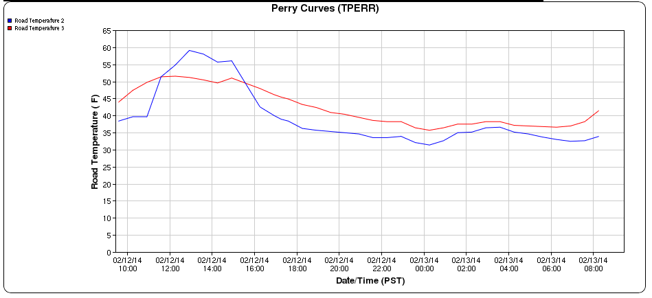
Pavement Temperatures at Perry Curves and I-90


While the pavement also warmed into the 50s on Wednesday, it cooled down into the 30s overnight.  The weather station at Perry Curves has 2 pavement sensors.  The blue graph shows that one of the sensors touched 32F at midnight, then warmed a bit, and fell again to 32F at sunrise.  

The reason for the overnight warming was another well-discussed topic on this blog:  clouds.  The skies were clear in the evening, which allowed the road temperatures to cool.  But clouds moved in after midnight for a few hours, causing the road temperatures to warm.  These clouds also brought some light rain, which provided the water for our icy drive this morning.  As those clouds cleared before sunrise, the pavement temperature once again dropped to near freezing, and the roads iced up.

Here's a graph from near Spirit Lake in north Idaho (click on the image for a larger view).

Air, Pavement, and Sub-surface temperature near Spirit Lake

This site shows the air temperature (blue line) this morning was around 39F.  The pavement temperature (red line) hovered around 32F all night.  And the sub-surface (light blue line) was just below freezing.

It's this sub-surface temperature that's made this winter so icy.  Remember that cold snap we had in early December?  Temperatures dropped into the teens with sub-zero readings at night.  But all of this was without snow on the ground.  We talked about this in our blog back then (click here to read it).  The lack of snow on the ground kept our temperatures from getting really cold. 

We've discussed before how important snow cover is to getting cold temperatures.  The snow acts as a blanket, and keeps the warmth in the ground from warming the air above it.  But the reverse is also true: the snow keeps the warmth in the ground and keeps the cold air out.  So during our bare-ground cold snap in early December, the lack of snow allowed the ground to freeze very hard, and very deep.  In most winters, we get snow on the ground before we get cold.  In that situation, the soil can go the entire winter without freezing.  And even it if does freeze, it's just the top inch or so of soil.

The other factor is the wind, or lack thereof.  In locations exposed to the wind, the roads weren't that icy.  Wind mixes the air and keeps it from getting cold.  But in the areas sheltered from the wind, temperatures were able to drop a couple of extra degrees.  It was mainly in these sheltered areas that the icy roads were most prevalent.

So here in mid-February, a warm sunny day can warm our roads rather quickly.  But the frozen ground helps to cool the roads as soon as the sun sets.  And as a result, we're still dealing with icy roads. The days are getting longer, the sun is getting higher in the sky.  So eventually, the frost will come out of the ground and we'll say goodbye to the icy roads.

The frozen ground was also the culprit behind yesterday's flooding.  We issued a flood warning before the rain started to fall.  But it wasn't for the rain;  it was for the melting snow.  In a normal winter, all that melted snow would have just soaked into the ground.  But with our hard-frozen soil, all the water from the melted snow just ran off.  Puddles, ponds, and lakes formed in areas where they typically don't.  Here's a couple of pictures from Colfax:

Flooding in Colfax on 12 Feb 2014


Flooding in Colfax on 12 Feb 2014

Here's the situation for one homeowner on the West Plains of Spokane.

Flooding near Coulee Hite Road on 12 Feb 2014

And a mobile home park on the West Plains also had flood issues.
Flooding on the West Plains of Spokane on 12 Feb 2014


Thursday, February 6, 2014

Snowfall opportunities in the coming days

With an Arctic air mass solidly entrenched over the northwest US, we're looking at the potential for snow for the Inland Northwest in the coming days.  As usual, these forecasts are going to be tricky.  So keep checking the forecast to stay up to date.

First, we'll start off with a look at this morning's minimum temperatures in the Pacific Northwest.


Low Temperatures Thursday 6 February 2014


Sub-zero temperatures were widespread in eastern Washington and northern Idaho. There were several locations which reported readings of -20°F, the coldest readings this winter.   Western Montana saw temperatures as cold as -40 degrees!  But notice that it was quite cold in western Washington and Oregon as well.

The first storm is already moving onshore today (Thursday).  Snow is falling over western Oregon, all the way to the coast.  Here's the webcam capture from the Oregon coast in the town of Pacific City.


Web camera showing snow at Pacific City Oregon, 6 Feb 2014

However, this storm will track across northern Oregon into southwest Montana.  This will leave most of the Inland Northwest on the northern fringe of the snowfall.  Below is the current forecast of snow for Thursday night through Friday:
Snowfall forecast for Thursday night and Friday morning (Feb 6-7 2014)

As you can see, those folks near the Canadian border will see the least amount of snow, while locations in southeast Washington the southern Idaho Panhandle will see the most.  The Spokane metro area is looking to get around 1".  The very cold temperatures will result in a light fluffy snow.  That coupled with the cold dry roads means that driving conditions shouldn't be too bad on Friday. However, there is some potential for blowing and drifting snow, especially over the Palouse and southeast Columbia Basin where northeast winds of 10-15 mph could stir things up considerably.  

The next storm will follow a similar track, and will move through the region on Friday night and Saturday.  The chart below shows the expected snow fall from this storm.

Snowfall forecast for late Friday night through  Sunday (Feb 8-9 2014)


After a break on Sunday, a weak front will bring light snow to most of the area on Monday.  At this point, this doesn't look like a big snow event.

Storm number four looks like it will move through the area by the middle of the week.  The computer models don't have great agreement on this system, so our confidence is low.

Throughout all of this, our temperatures will gradually be warming.  The image below gives you an idea of what we're looking at for Spokane.


7-day forecast for Spokane
As the graph shows, by the middle of next week, our temperatures will have returned to near normal for this time of year, which means highs in the upper 30s and lows in the mid 20s.

One thing to note.  Typically in these warm ups after a cold arctic intrusion, the cold air near the surface is tough to scrub out.  This can set the stage for freezing rain.  At this point it's too far in the future to predict where and when this will occur, if at all.  But most likely it would be between Monday and Wednesday of next week.

The outlook through the third week of February suggests the warming will continue with more wet weather. It's quite conceivable the weather we just experienced will be the coldest of the winter. The sun angle is getting higher by the day, while the days are steadily lengthening. By February 20th, the length of daylight will be 10 hours and 38 minutes, a gain of 47 minutes compared to today. 

  
8-14 day temperature outlook

8-14 day precipitation outlook