


And all the while the car thermometers indicated that the air temperature was well above freezing. What in the world was going on this morning?
And a mobile home park on the West Plains also had flood issues.
If you've been reading this blog over the past few months, you've seen that we've referred to the ground temperatures more than once. And that was the culprit again. Yes, the air temperatures warmed into the 40s on Wednesday. And the sun came out. So the roads warmed up and dried off. Below is a graph of the Air Temperature at I-90 and the Perry Curves in downtown Spokane
 |
| Air Temperature at Perry Curves and I-90 |
Wednesday afternoon saw air temperatures into the lower 50s over I-90. And as you can see, the temperature only fell to 40 degrees at midnight, and then warmed into the lower 40s for the rest of the night. No freezing there. Or was there? Take a look at the pavement temperature:
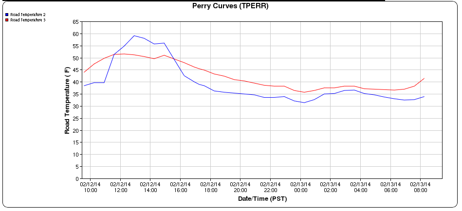 |
| Pavement Temperatures at Perry Curves and I-90 |
While the pavement also warmed into the 50s on Wednesday, it cooled down into the 30s overnight. The weather station at Perry Curves has 2 pavement sensors. The blue graph shows that one of the sensors touched 32F at midnight, then warmed a bit, and fell again to 32F at sunrise.
The reason for the overnight warming was another well-discussed topic on this blog: clouds. The skies were clear in the evening, which allowed the road temperatures to cool. But clouds moved in after midnight for a few hours, causing the road temperatures to warm. These clouds also brought some light rain, which provided the water for our icy drive this morning. As those clouds cleared before sunrise, the pavement temperature once again dropped to near freezing, and the roads iced up.
Here's a graph from near Spirit Lake in north Idaho (click on the image for a larger view).
 |
| Air, Pavement, and Sub-surface temperature near Spirit Lake |
This site shows the air temperature (blue line) this morning was around 39F. The pavement temperature (red line) hovered around 32F all night. And the sub-surface (light blue line) was just below freezing.
It's this sub-surface temperature that's made this winter so icy. Remember that cold snap we had in early December? Temperatures dropped into the teens with sub-zero readings at night. But all of this was without snow on the ground. We talked about this in our blog back then (click here to read it). The lack of snow on the ground kept our temperatures from getting really cold.
We've discussed before how important snow cover is to getting cold temperatures. The snow acts as a blanket, and keeps the warmth in the ground from warming the air above it. But the reverse is also true: the snow keeps the warmth in the ground and keeps the cold air out. So during our bare-ground cold snap in early December, the lack of snow allowed the ground to freeze very hard, and very deep. In most winters, we get snow on the ground before we get cold. In that situation, the soil can go the entire winter without freezing. And even it if does freeze, it's just the top inch or so of soil.
The other factor is the wind, or lack thereof. In locations exposed to the wind, the roads weren't that icy. Wind mixes the air and keeps it from getting cold. But in the areas sheltered from the wind, temperatures were able to drop a couple of extra degrees. It was mainly in these sheltered areas that the icy roads were most prevalent.
So here in mid-February, a warm sunny day can warm our roads rather quickly. But the frozen ground helps to cool the roads as soon as the sun sets. And as a result, we're still dealing with icy roads. The days are getting longer, the sun is getting higher in the sky. So eventually, the frost will come out of the ground and we'll say goodbye to the icy roads.
The frozen ground was also the culprit behind yesterday's flooding. We issued a flood warning before the rain started to fall. But it wasn't for the rain; it was for the melting snow. In a normal winter, all that melted snow would have just soaked into the ground. But with our hard-frozen soil, all the water from the melted snow just ran off. Puddles, ponds, and lakes formed in areas where they typically don't. Here's a couple of pictures from Colfax:
 |
| Flooding in Colfax on 12 Feb 2014 |
 |
| Flooding in Colfax on 12 Feb 2014 |
Here's the situation for one homeowner on the West Plains of Spokane.
 |
| Flooding near Coulee Hite Road on 12 Feb 2014 |
And a mobile home park on the West Plains also had flood issues.
 |
| Flooding on the West Plains of Spokane on 12 Feb 2014 |
No comments:
Post a Comment