The setup
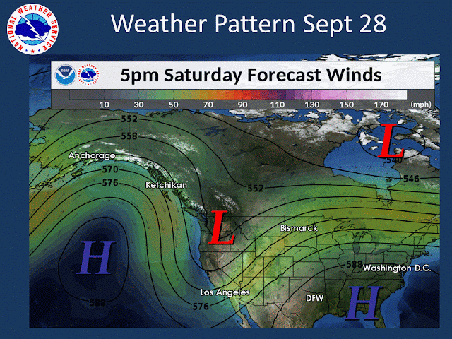
So why is this happening? An amplified ridge of high pressure in the Eastern Pacific and a deep cold low over our region according to this model prediction.
 |
| 12z/Sept 26th GFS forecast of 500mb heights and 250mb winds valid 11 AM PDT Saturday Sep 28th, 2019 |
The image is the jet stream diving south off the coast into California.
And this low is not in a hurry to move. Here is a closer look at the storm for Saturday morning. The image is relative humidity with bright green indicating higher moisture content and thus better chances for precipitation.
 |
| 12z/Sept 26th GFS forecast of 500mb heights and 850-500mb relative humidity valid 8 AM PDT Saturday Sep 28th, 2019 |
And now Sunday morning
 |
| 12z/Sept 26th GFS forecast of 500mb heights and 850-500mb relative humidity valid 11 AM PDT Sunday Sep 29th, 2019 |
This low doesn't move much, with bands of precipitation continuing. Also during this time frame we will have cold continental air pouring into the region. Winds blow from high pressure to low pressure. The tighter the lines are together, the stronger the wind. Note the tight packing over the North Idaho Panhandle especially.
 |
| 12z/Sept 26th GFS forecast of MSLP valid 8 AM PDT Saturday Sep 28th, 2019 |
Early season snow
Snow this early in the season is uncommon. Below is a chart showing snowfall records for the month of September, and the number of days of measurable snow recorded during the entire period of record for the month. Getting measurable snow in September has either never happened, or only once in the entire climate record for all towns across the area except Priest River with two occurrences.
So where will it snow? A near certainty in the mountains. Valleys will depend on elevation. Here is our forecast issued Thursday afternoon regarding possible snow accumulations through the weekend.
The mountains will see 6+ inches for many locations. The valleys have the potential for light snow amounts Saturday night into early Sunday on grassy surfaces mainly above 2000-2500 feet and across the North Idaho Panhandle.
Keep in mind ground temperatures are warm this time of year. This will reduce the threat of snow accumulations on roads during the day with the overnight and early morning hours the most likely period of winter driving conditions in the mountains. But any heavy bands of snow that set up could result in slushy conditions during the day as well.
Snow levels will be falling this weekend. Here are the forecast snow levels Saturday morning.
And now Sunday morning
Does this mean snow in your town? Knowing your elevation can help when we are talking snow levels. The tables below show elevations for selected towns and several high elevation highways and passes.
Strong winds
Saturday will have the strongest winds. Here is the peak wind gusts forecast for Saturday
The strongest winds are expected from Sandpoint to Coeur d'Alene and across parts of the Upper Columbia Basin. Winds of this magnitude may result in localized downed trees and power outages. These winds this time of year would typically pick up blowing dust across the Columbia Basin but expected precipitation should minimize this threat. The winds will persist Sunday but not as strong. The winds will make it feel even colder as noted in next section.
Unseasonably cold temperatures
Freezing temperatures will soon be hitting many areas beginning Sunday morning. Here are the forecast lows for Sunday morning
But the wind will make it feel colder. Here are the forecast wind chill values for Sunday morning
 |
| Sunday morning wind chill forecast |

Those with morning plans bundle up! Freezing temperatures are expected for most while a hard freeze is possible in the colder spots.
The high temperatures this weekend are noteworthy as well. Daily records will likely be achieved in many areas beginning Saturday. Monthly records are also within reach. Here are the coldest September high temperatures ever recorded.
 |
 |
| CPC 6-10 day temperature (left) and precipitation (right) outlooks issued Sept 26th, 2019 |
This weekend will be a noteworthy September storm. Get ready for winter like conditions. And if you have travel plans east into Montana, conditions will be even worse, much worse!
 | |
| NWS Forecast of snowfall issued Thursday afternoon valid Friday night through Monday |
NWS Spokane: link
NWS Missoula: link
NWS Great Falls: link
NWS Billings: link
NWS Glasgow: link


