A strong cold front on Tuesday (Sep 24) will likely deliver windy conditions to the Columbia Basin, Spokane area, and Palouse which will be followed by much colder temperatures with highs in the 50s by next weekend.
Here is the latest outlooks issued today (Friday) valid Sept 26-30th.
 |
| CPC 6-10 day temperature outlook issued Sept 20 valid Sept 26-30 |
 |
| CPC 6-10 day precipitation outlook issued Sept 20 valid Sept 26-30 |
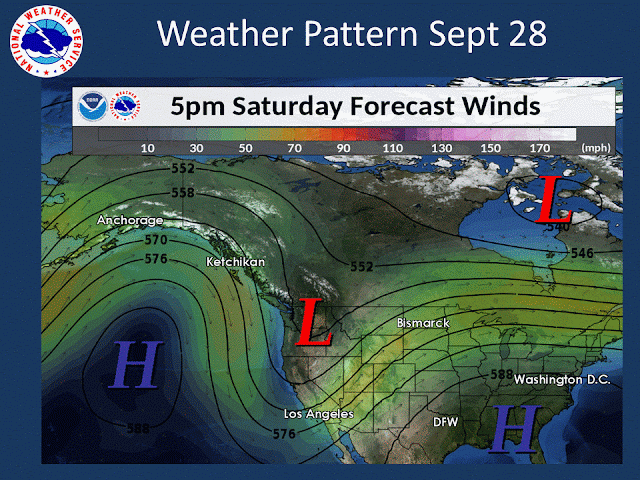
Here is what one model is showing regarding the weather pattern.
 |
| 12z GEFS forecast of 500mb heights and wind valid 5 PM PDT Saturday, September 28th |
A large ridge in the Eastern Pacific and a deep trough over the Pacific Northwest.
Prior episodes such as this one (analog cases)
Based on the forecast pattern, the following graphics show the odds of below normal temperatures based on previous patterns that set up such as this one. Here is the odds of below normal temps days 6-8 (Sept 25-27) based on previous events.
And now for days 9-11 (Sept 28-30)
And regarding mountain snow potential, let's begin with snow levels. Here are the forecast snow levels published Friday afternoon for the morning hours of Thursday, Sept 26th.
 |
| NWS forecast snow level published Sept 20th valid the morning of Sept 26th |
 |
| NWS forecast snow level published Sept 20th valid the morning of Sept 27th |
Much colder night time temperatures
Also of note is going to be a huge change in low temperatures. Much of the region has experienced mild nights over the past 30 days thanks to cloud cover, and above normal moisture content in the atmosphere as the map below shows.
 |
| Departure from normal min temperature map valid Aug 20-Sep 18, 2019 |
Typically by late September, lows are in the upper 30s and 40s for most towns. And even freezing temperatures have occurred in the colder spots. Below is a table showing the average first freeze date for selected towns.
With the much colder weather, places that typically have had a freeze by now (Deer Park, Republic, Colville, Winthrop) have a very good chance of seeing their first freeze. For places further down the list including Omak, Pullman, Kellogg, Ritzville, and Spokane it's too soon to have much confidence about freezing temps. Lewiston and Wenatchee likely will have a tough time freezing this early.


No comments:
Post a Comment