Here is the Infrared Satellite picture as of 11 am this morning
 |
| Infrared Satellite image as of 1801z (11:01 AM PDT) today (Aug 21st, 2019) |
A clearly defined front was noted over southwest Oregon noted by the colder cloud tops (green and yellow shaded area) extending north up into western WA. It was raining over most areas of SW Oregon.
Next we will take a look at GFS model projections going into this evening.
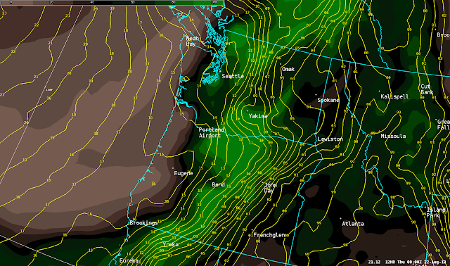
2 PM today
 |
| 12z GFS forecast of MSLP and 700-500mb Relative Humidity valid 2 PM PDT Aug 21st, 2019 |
There are two items to keep your eye on.
- Yellow lines which are lines of constant pressure. The closer these are to each other, the stronger the winds. Note at this time (2 PM) these lines are close together between Seattle and Omak (along the East Slopes of the Cascades) where breezy winds are likely.
- Background image showing moisture content in the mid levels of the atmosphere. Green is higher moisture content which is a more favorable area for rain while brown is dry areas. So at this time a band of rain is progged to impact areas between Portland and Bend, with another area up over the North Washington Cascades.
 |
| 12z GFS forecast of MSLP and 700-500mb Relative Humidity valid 5 PM PDT Aug 21st, 2019 |
Note now pressure packing of the yellow lines is spreading east into the Columbia Basin and thus increasing wind. Rain chances are also beginning to spread east of the Cascades.
8 PM today
 |
| 12z GFS forecast of MSLP and 700-500mb Relative Humidity valid 8 PM PDT Aug 21st, 2019 |
Note at this point the pressure packing of the yellow lines spreading east into Spokane and the Palouse with increasing wind for these areas. Rain chances increasing across the Columbia Basin, and nearing the Spokane area and Palouse.
11 PM today
 |
| 12z GFS forecast of MSLP and 700-500mb Relative Humidity valid 11 PM PDT Aug 21st, 2019 |
The burst of wind is progged to be moving out of the area into parts of Central Idaho and NW Montana. While rain will likely be spreading into much of the eastern third of Washington into the Idaho Panhandle.
So how strong will the wind gusts be? The potential exists for 30-45 MPH gusts across portions of the Columbia Basin, Spokane area, and Palouse as well as many area lakes. Here is our forecast timing of the expected wind gusts.
And what about rain amounts? All areas will have a chance for rain, with SE Washington into the Idaho Panhandle the most likely candidates for a wetting rain between a tenth to a quarter inch.


No comments:
Post a Comment