Since our last mini heat wave around the 10th of June, temperatures across the Inland Northwest have generally remained above normal. If we just focus on afternoon highs, the term "above normal" suggests that we are warming above 30-year averages which range from the lower 70s to lower 80s
°F. I think it's safe to say that the current string of above normal warmth has been manageable with highs only a handful of degrees above June's standards. Dryness levels on the other hand, are another story, but we will reserve that for a different time.
Following that early June heat wave, a low-amplitude jet stream has been in place across the Eastern Pacific, Pacific Northwest, and Upper Midwest. We have seen a few minor shortwaves rippling through at times but overall, no major storm systems or swings in temperatures. Another feature of note has been a persistent area of low pressure residing over British Columbia.
 |
| Saturday jet stream (color contours) overlaid with 500 mb heights |
This low has helped the flow remain flat and as a result, prevented the dome of heat strengthening over the Desert Southwest from expanding northward. This time of year it's not uncommon for triple digit heat in the Desert Southwest but it has been anything but normal. Temperatures in Phoenix for mid June typically range 103-105
°F. On Friday, Phoenix warmed to 114
°F, marking the 5th consecutive day that temperatures exceeded 111
°F
 |
| High temperatures Friday 6/19 |
Now let's shift our focus to the forecast. Sunday to Wednesday, only minor changes are expected. The trough currently off the coast will weaken while traversing the region. It will increase the risk for mountain thunderstorms and deliver locally breezy winds but temperatures will generally remain steady in the upper 70s to 80s °F. By Thursday, the pattern over the Pacific will begin to shift. The area of low pressure currently along the western tip of the Aleutian Islands will shift east, amplify, and become the dominate area of low pressure between the Rockies and the International Dateline. Yes, this means the persistent area of low pressure that has been lingering over British Columbia will finally depart.
 |
| Saturday morning Water Vapor satellite image with 500mb heights overlaid |
If we fast forward to Sunday, here is the output from the GFS weather model:
 |
| Sunday (June 27th) jet stream (color contours) overlaid with 500 mb heights |
The GFS is indicating a ridge of historic proportions across the Western US. Will this really pan out? Lets see how additional models stack up.
 |
| 4 different model output for Sunday (June 27th). Jet stream (color contours) overlaid with 500 mb heights |
|
As you can see, there is good agreement that a strong ridge will develop over the Western US but definitely some uncertainty exactly when the ridge will be strongest over the Pacific Northwest. The model output from the "less amplified" solutions did support the GFS output at one time or another but Saturday morning runs trended a bit flatter, at least for the Sunday time-frame. When I investigated those "flatter" models a bit further, I noticed two things: 1) They eventually come into line with the GFS, just a day or two later and 2) They still indicate enough warming in the lower-levels to support 90-100s
°F.
Confidence is rapidly increasing for a strong warming trend for next weekend and early next week which is likely to yield temperatures 15 to 25 degrees above normal.
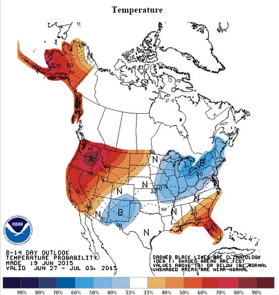
The Climate Prediction Center outlook would agree.
What are the odds we see record heat? First lets see how this compares historically. Utilizing the GEFS (Global Ensemble Forecast System) and M-climate Return Interval, we see that 850 mb temperatures by Saturday evening are already approaching values seen once every 10 years in Southeastern WA and outside the database near the Cascades and Northern Mountains. This particular model output does not have data for Sunday onward but I imagine a similar signal.
 |
| M-climate return interval from GEFS mean 850mb temp |
 |
| Example of sounding climatology from SPC. This particular graph plots historic 700 mb temps |
Of a few variables examined, output from the GFS indicated the possibility that the ridge could be of historic proportions for these dates in June.
If these numbers were to come to fruition, record temperatures are a strong possibility. More importantly, the excessive heat will impact numerous outdoor sporting events, recreation, and festivals that are scheduled for the weekend and continue to have large impacts on outdoor activities and workers early next week. The NWS forecast only goes out through Saturday so for the time being, here is the temperature forecast from the BCCONSALL, one of our more reliable model outputs that uses an average of medium range guidance and applies a bias correction. In summary, highs will have the potential to soar into the 90s and 100s Saturday with many locations near or exceeding triple heat thereafter.
SATURDAY 6/27
 |
| BCCONSALL High Temperature Forecast for Saturday 6/27 |
SUNDAY 6/28
MONDAY 6/29
To put this into perspective, many locations could come close to breaking their all time warmest June temperature with the current records listed in the table below.
Tuesday could be just as hot! As we go into July, the outlook from the
CFS does not offer much hope that the Northwest will cool off anytime soon. Note the warm anomaly in 850 mb temperatures planted directly over the Northwestern US.
So a good blog always adds some doubt to the main argument right? Well, we were faced with a similar scenario two years ago when forecast models advertised a major heat wave for the end of June. This happened to correlate with a large basketball tournament held in downtown Spokane. The weather models a week out were shouting HOT HOT HOT! Long story short, it was warm but not unbearable as a combination of clouds and thunderstorms kept temperatures in check. Will history repeat itself? Stay tuned!