Storm #1 will be the weakest and will arrive Tuesday afternoon and night. It should bring widespread light snow to the area, which will start late this afternoon. The image below shows how much snow we are expecting by Wednesday morning.

The official forecast is for Spokane and Coeur d'Alene to see between 1" and 2". The HRRR (3km Rapid Refresh model) is forecasting a bit more snow. It suggests 1-2" for western Spokane but 2-3" for Coeur d'Alene and Deer Park. The NAM and GFS models (not shown) forecast more like 3-5" for the metro area, but these predictions have been trimmed back because the majority of this system will be moving by to the south of Spokane. The heaviest snow will be east of Moscow, ID.

Some of the road pavement temperatures could be above freezing in some areas when the snow starts. As we've discussed before, in these situations the initial snow fall will melt on the roads. But since the air temperatures and ground temperatures are below freezing, the melting process quickly cools the road surfaces back to freezing. This causes the melted snow to freeze to the road surface as more snow accumulates. The result is very slick roads.
Storm #2 will arrive Wednesday afternoon. A bit stronger than Storm #1, it will start to push some of the cold air out of the area. As such, precipitation will start off as snow in Spokane and the Palouse but change to rain Wednesday evening. The northern valleys should remain as snow through Wednesday night for this event and could see a few inches.
The potentially big storm arrives late Friday. This will be a valley rain / mountain snow event. Precipitation in the Panhandle mountains will likely be considerable, with snow levels rising to 4000' in the north and 5000' in the central Panhandle.
The cold frontal passage will occur sometime on Saturday. All of the models show strong winds with the cold front. But the GFS has the strongest winds, all thanks to a very deep low. The image below shows the GFS forecast for Saturday morning.

At this point, the GFS forecast's a 980mb low over central BC. Twelve hours later, the low has moved into the Canadian prairies and deepened to 976mb.

This is a very good pattern for strong winds in our area. But, as we said, the other models, while windy, are not as strong as the GFS model. So at this point, we have a windy forecast. But if the other models start to trend towards the GFS model, we'll be increasing the winds in our forecast.
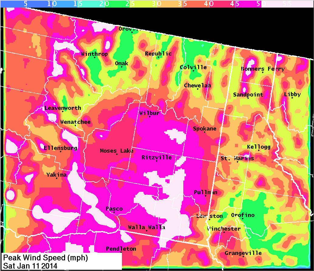
The image above shows the predicted peak wind speeds. Areas in white would be over 50 mph. Stay tuned to the forecast for this storm. We'll probably update the blog Wednesday or Thursday.
No comments:
Post a Comment