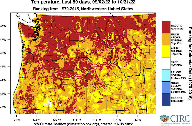
Thus far the Fall of 2022 has been an unusually mild one. For the Spokane area, the period from September 1st through October 31st was the 3rd warmest on record and the warmest since 1952.
It was also the warmest October on record for Spokane, by a relatively impressive 0.5°F.
Weather enthusiasts usually have to wait a while for a high-impact event to come along. That's what makes this upcoming set of weather events so impressive. We won't be able to give a ton of detail to each event or this blog would run on forever. So we'll try to hit the high points.
The first act will be the snow. This will be the first snow of the season for many lowland locations in the Inland NW. The precursor is already in place, namely, a cold atmosphere. That is complements of the very slow cold front that moved through the region on Monday and Tuesday and has left an unstable and cool trough located over the area this evening (11/2/2022).Now some of the computer models are forecasting a heavy snow event for a few locations, most notably the Idaho Panhandle and Northeast Washington.
But the issue that these models don't really account for is that;
- The surface air temperatures won't be all that cold. Most locations will be right around freezing by the time the precipitation begins on Thursday night and hold somewhat steady through the night.
- The ground temperatures are still considerably warmer than freezing, since it's only early November.
Our snow storm is followed by a strong wind storm Friday night as the cold front comes marching through. An impressively strong 160 knot jet stream will be right over our area Friday night and Saturday morning. This is not good news.
The biggest fly in the ointment could be a non-meteorological factor: tree leaves. Our mild fall has meant that the deciduous trees are decidedly late in losing their leaves. This could have implications for both the snow and the wind. If the temperature is just right (not to warm or too cold), wet snow will stick to the leaves, adding considerable weight to branches that aren't accustomed to it. The resulting tree damage could temporarily block roads and cause power outages.
Our Saturday will still be windy, but mostly dry. This will serve as the breather between the weather systems. And it doesn't last long. The next Pacific storm will follow a different track, moving by to our south. This track favors heavier snow for the Cascade folks (Omak and Wenatchee) and less snow for other locations. And the snow won't change to rain with this pattern. Also in the image below, you can see all of the thin black lines, or isobars, over the Idaho Panhandle and northeast Washington. That means cold, brisk northeasterly winds as an arctic air mass pushes in from Canada.
The resulting snow totals could be rather impressive for the Cascades. The GFS forecast is pretty impressive, and the ECMWF forecast (not shown) is equally significant.
The GFS Ensemble (think of this as the average of 30 different perturbations or varieties of the initial GFS model) also points to heavy snow potential for north-central Washington.
Remember, this is still 4-5 days out. The forecast keeps changing, so we wouldn't hang our hat on this scenario at this point. Everyone in the Inland Northwest should keep checking the forecast updates over the next couple of days.
The last act in this string of weather events will be the unusually cold conditions. We have much higher confidence of this than snow amounts or wind speeds. The cause of this pattern shift will be the upper level jet plunging well south of the area with the air mass coming out of the Yukon or Northwest Territories.
Daytime temperatures will remain below freezing for many locations next Monday through Wednesday (if not longer), with nighttime temperatures in the 20s and teens. Here's is the high temperature forecast from the ECMWF ensemble for Tuesday:
In case you were wondering, yes some of these forecast values are record cold highs for the date. The record cold high for 11/7 is 32°F set in 2017 and we have a forecast of 33°F. The forecast for 11/8 is 30°F with the record for the date being 26°F set in 1945.
So there you have it. A Thursday night snow storm chased by a Friday night wind storm and then followed by yet another snowstorm for Sunday night. The end of the story will be a very good chance of seeing an unusually early arctic cold snap next week. Remember, November is still an autumn month although it won't feel much like it. And by the way, the latest 8-14 day outlook isn't giving much of a chance of breaking out of this cold pattern anytime soon.


.png)


.gif)
No comments:
Post a Comment