We've never seen a drought like this
It's well known that weather in the western US is drier than in the eastern US. As such, droughts are more common in the West. Most of the West is designed to accommodate this drier climate. The mountains get heavy snow in the winter, which slowly melts off in the spring and summer. There are numerous dams throughout the West which catch much of the snow melt, using it to irrigate our farmland (as well as generate electricity). This enables western farmers to grow crops in some rather arid locations.
Still, there are some areas in the West that, similar to their eastern counterparts, rely solely on the rain and snow to irrigate their croplands. In the West we call this "dryland farming". The biggest example of this is typically wheat and barley, but also includes a lot of hay. The Inland Northwest is known as one of the largest producers of wheat in the US.


These dryland crops require moisture through the spring and into the early summer. Grains such as wheat and barley will ripen during the hot summer months and so they don't really require much if any rain at that point until they are harvested in late summer. This matches the usual rainfall patterns we see here in the Inland Northwest. But not this year.
Rainfall this spring hasn't just been light, it's been nearly non-existent. We haven't seen anything like this before. Spokane just finished it's driest February through May ever. EVER. Records for Spokane go back to 1881. That means this was the driest spring in 140 years! And it wasn't just Spokane. The dark red area in the image below shows all of the areas that have had their driest February-May on record.

As you can see, it's been dry over much of the Northwest this spring, but the Inland Northwest has been the epicenter of this dryness. The three month period of March through May was the driest for many other locations in the Northwest.

So the natural question is "what caused this drought?". The answer isn't straightforward and probably incomplete given our current understanding of weather and climate. One contributor that we are aware of is La Nina. To which you may be saying "I thought La Nina meant wetter than normal conditions for our area", and you would be correct. Here's a diagram showing the basic jet stream pattern for a typical La Nina that you may have seen before:

The purple and orange lines are meant to represent the variable jet stream patterns we normally see during a La Nina winter/spring. The purple line shows a colder phase of the jet stream, diverting up into Alaska and then bringing colder but drier air into the Northwest US. But then the jet stream will also at times follow the orange line, bringing Pacific moisture into the Northwest. The problem is that for the spring of 2021, we've seen a LOT more of the purple jet stream, and not so much of the orange jet stream.
Note in the image above the big H and the blocking High Pressure in the Gulf of Alaska. Here's the air pressure anomaly at about 18,000 feet in the atmosphere from the Feb-May period this spring.

What this shows is that the air pressure in the Gulf of Alaska has been higher than normal this spring. This compares very well with the idealized La Nina image previously shown with the Blocking High in the Gulf of Alaska. So this looks like what we would expect for a La Nina winter/spring.
But now here's the jet stream anomaly for this past spring:
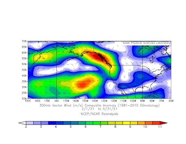
But then look at the other area of bright colors in the image above, out in the eastern Pacific. Those show that the jet stream across the Pacific has been much weaker and infrequent than normal. So the "orange" jet stream that is supposed to bring the moisture, hasn't been doing its job this spring.
The result is that we've been getting a lot more of the "purple" jet stream from the northwest (which is a dry weather pattern), and not nearly enough of the "orange" jet stream from the Pacific (which is a wet weather pattern).
Is there any hope of this pattern changing? Officially, the Climate Prediction Center declared the 2020/21 La Nina over. That's not to say that our weather pattern will necessarily change, especially since we are heading into the typical hot dry summer season.
Here's the computer forecast for the June-July-August season for temperature and precipitation. They call for a warmer and drier than normal summer overall all of the western US.


But this of course is a computer forecast. And you may be wondering if the computer forecasts correctly predicted our record dry spring. That's a good question, and the answer is no, the computers never saw it coming. Here's the forecast made back in February 2021 for the Feb-Mar-Apr timeframe. That area of light blue in the Inland Northwest shows that the computer actually expected that we would see normal or possibly wetter than normal conditions for our area, which agreed with the usual La Nina pattern.

No comments:
Post a Comment