This week it will be hot and dry for most of the Inland Northwest and the Pacific Northwest. Seeing some of the model guidance and predicted temperatures for this week and next weekend reminded us of the June 27-28 heatwave of 2015 (you can read our blog post here). Let's dive into the comparisons of this heatwave vs 2015 and lay out the expected forecast for this week.
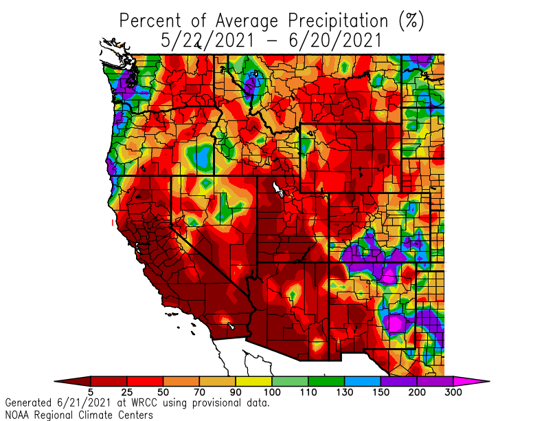
We talked earlier this month about our record dry spring, and in the last 30 days the story of very dry conditions continues. Many locations did receive some good rain from the thunderstorms of June 15th. But the total amount of precipitation in the Inland Northwest has been very low. For many places, around 25% of average or lower.
Here’s a look at our normal precipitation for May and June (since June isn’t complete yet, we went back into May) shown by the brown line, what we have accumulated on the green line, and compared this to 2015 since we know that year saw a hot spell in June. We can see that compared to 2015, this year (2021) is drier for the May - June period.

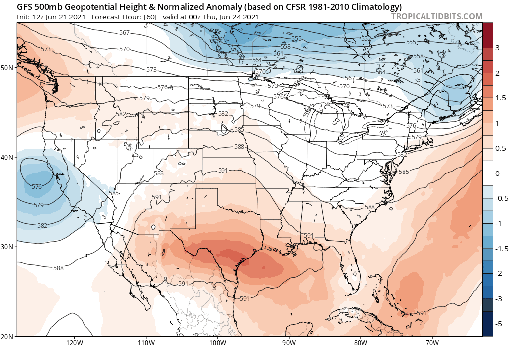
Taking into consideration the very dry spring and now start to summer, along comes a strong ridge of high pressure that will continue to strengthen and settle over the northwest. Below is a loop of the 500mb heights and anomaly from the GFS model, Thursday through next Monday. For this weekend and early next week, extremely strong high pressure will dominate southwest Canada and the northwest US.
For June in eastern Washington (we’ll use Spokane International Airport as a point of reference), the normal high temperature is 74F. This week, we’re looking at temperatures 10 to 25F degrees above normal, or higher. Yes, higher. By next weekend, daytime temperatures in the 100-105F range are possible. This kind of heat hasn’t been seen since 2015, and thus why we look back to 2015 to see what kind of conditions were going on and what the models were saying then, giving us an idea of what might be to come this week and weekend.

Putting this into perspective, the record hottest temperature ever for Spokane is 108F set on Aug 4, 1961.
Going back to the comparison of 2015, June 27-28 saw temperatures of 102F (27th) and 105 (28th), with upper 90s on days leading up to and after that heat wave. The afternoon of June 28th, the 850mb temperature was 29.6C giving us that max temperature of 105F. What do the models say for our 850mb temps this week and next weekend? Below is the sounding climatology from SPC for Spokane (OTX) for 850mb temperatures. The all-time max 850mb temperature is 31.5C from early August.

Current deterministic model guidance for 850mb temperatures are quite jaw-dropping:
ECMWF:
Saturday - 28.85C
Sunday - 30.85C
Monday - 33.85C
Tuesday - 35.3C
Wednesday - 32.0C
GFS:
Saturday - 28.3C
Sunday - 29.7C
Monday - 33.2C
Tuesday - 34.5C
Wednesday - 33.3C
So all around very hot temperatures for this weekend and into early next week. Leading up to Sunday, the ridge strengthens Friday through Sunday with Sunday looking like the hottest in the next 7 days, which is as far as our forecast goes out at this time.
What about beyond Sunday? Forecast model guidance gets tricky the farther out in time, however strong high pressure patterns are ones that have a tendency to be more persistent, so confidence isn’t completely out the window with the idea that this heat could last into the middle part of next week. Ensemble guidance has also been very consistent in highlighting this strong ridge through early next week. The suite of models are showing 850mb forecast temperatures next Tuesday of 33C - 35C. We have many days between now and then, so these numbers may fluctuate a bit but this is something to keep in mind.
In 2015, we observed 4 days of maximum temperatures 100+F, and in 2020 we observed 3 days (the most is 6 days set in 1928).
The Climate Prediction Center is highlighting a high percentage of excessive heat for June 29-30, next Tuesday and Wednesday. This would suggest our ridge has lower chances of breaking down and better chances of this heat to persist into the middle part of next week.

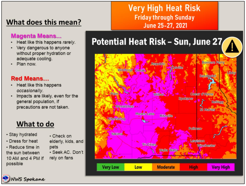
Other factors we have to take into consideration are the overnight low temperatures. With such strong heat during the day, the overnight relief may become less of a relief. Together, this will increase our heat risk for various populations in our region. Currently, here is a snapshot of our heat risk forecast.
Our confidence is fairly high that we will see this prolonged heat last into early next week with this upcoming weekend seeing the hottest temperatures of the year, the hottest since 2015, and the hottest in the next 7 days. After that, it’s possible we will see continued hot temperatures and perhaps slightly hotter?
No comments:
Post a Comment