A heat wave like no other is becoming increasingly likely. Prepare NOW!
The biggest heat wave to ever strike the Inland NW on record is becoming increasingly likely. What makes this event unique?
- All time record high temperatures are in jeopardy for several locations
- And this is during June (our peak heat season is late July through early August)
- 100+ degree temps will last for several days
- Mild overnight lows in the mid 60s to upper 70s will provide little to no relief at night
- Occurring during a period of severe to extreme drought
- Fire danger increasing to record levels next week and as we near the 4th of July (for this early in the season)
The Climate Prediction Center's latest Risk of Hazardous Temperatures product shows our region in a high risk of Excessive Heat through next Friday, July 2nd. Don't be surprised by future outlooks extending this out further.
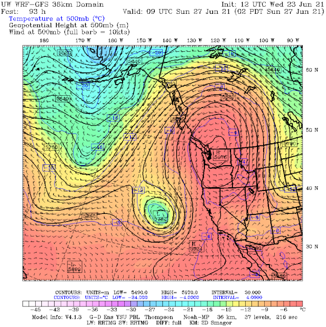
What is going to cause the excessive heat? A very strong ridge of high pressure (record setting for late June by some model solutions). Here is one ensemble solution showing the strong ridge centered right on top of us on Sunday.
 |
| 12z GFS model of 500mb heights, winds, and temperatures valid 2 AM PDT Sunday, June 27th 2021 |
Strong high pressure in late June spells trouble! Why? The lower atmosphere continues to warm as the ridge persists over the region as the late June sun angle brings an abundance of solar radiation towards the Earth's surface which continues to warm things up each day. Here is one model prediction of near surface temperature anomalies from this Thursday through the following week (June 24-July 3rd).
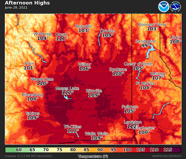
So it looks like this heat wave will be around for awhile, but how hot will it get? Our current forecast is calling for all time records to be threatened beginning Monday.
 |
| NWS Forecast High Temperature for Monday, June 28th (issued June 23rd) as compared to current all time records. |
And if we don't break the all time records on Monday, we will probably have another shot on Tuesday and Wednesday! Here is our current forecast as of June 23rd for Tuesday.
It is worth noting that a few models (especially the GFS) want to take the heat up another notch, suggesting temps near or above 110F for Spokane and near 120F for Moses Lake.
Spokane
 |
| Meteogram of forecast raw model temperatures for GEG (Spokane International Airport) through Wednesday, June 30th, 2021 |
Moses Lake
 |
| Meteogram of forecast raw model temperatures for Moses Lake through Wednesday, June 30th, 2021 |
While these values are not currently forecast, it does have our attention. The record for the state of Washington and Idaho is 118 degrees at Ice Harbor Dam, WA and Orofino, ID so we will be watching for this potential closely.
What other impacts are expected? As mentioned in a previous blog post, here, our region is currently experiencing severe to extreme drought over much of Eastern Washington into the Idaho Panhandle. The unprecedented heat is not good news for the region. Wheat and hay crops are already starving for soil moisture, and this upcoming heat will only make the soils drier than they currently are.
And what about fire danger? Fuel moisture is expected to dry out considerably, reaching record low values for late June. Fuel moisture comes in different sizes, but all are measures of how dry the grass, twigs, branches, and timber are.
Forecast 100 hour (branch size) dead fuel moistures based off model data from the NWCC (Northwest Interagency Coordination Center) are shown below. Red is observed, while blue is the forecast. The bottom gray line is the minimum value on record. The plot below is for NE Washington but the same idea applies to other areas of Central and Eastern Washington into the ID Panhandle. As you can see the red line has dipped near the minimum value several times since mid-May (likely due to the drought). The blue forecast line is expected to drop fuel moisture to record lows for this time of year.
Safety tips
So what can you do to stay safe during this heat wave? Here are some suggestions
- Drink plenty of fluids and wear light colored clothes
- Check on and take care of those vulnerable to heat (children, those with chronic medical conditions, elderly, pets)
- Stay inside during the hottest times of the day (afternoon and early evening)


No comments:
Post a Comment