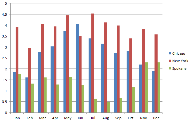
Much of the U.S has the majority of their precipitation in the summer (Chicago), or it's fairly evenly distributed throughout the year (New York). In the West, it's the other way around. We have a distinct dry season in the summer, and wet season in the winter.
After the hot dry summer, Pacific storms in September and October typically become more frequent, and increasingly wet. And then in November, the storm door really opens; it's twice as wet as October. In fact, for most of the Inland Northwest, November is the wettest month, followed closely by December and January. (The exception to this is Lewiston, which has it's wettest month in May).
This year, the storm door looks like it will open rather suddenly. The storms for October have been fairly weak and temperatures have been near record warmth. But all of that will change this weekend. Below is the forecast rainfall for the next 5 days from 2 forecast models, the GFS and Canadian.
 |
| GFS Predicted Precipitation Oct 29 - Nov 2 2015 |
 |
| Canadian predicted precipitation 29 Oct - 2 Nov 2015 |
Now, before you go thinking that Wenatchee is going to get 0.5" to 1" of rain, or Spokane is going to 2" of rain, these models are notorious for spreading the rain too far away from the mountains into the lower elevations. They know that the Mountains exist, but they don't have enough resolution to account for just how sharp the rain shadow is.
The weather pattern that's going to bring us all this rain is a strong jet stream from west to east. That kind of pattern produces a large rain shadow east of the Cascades, that extends at times all the way to Coeur d'Alene. So for the area from Wenatchee to Spokane to Lewiston, take those computer forecasts and cut them in half, and you're probably in the ball park of what will happen. For the Cascades and Panhandle mountains, the computer forecasts are probably a bit too low. In other words, the western Cascades could see a foot of rain by Monday morning, and the Panhandle Mountains could see 6" or so. That's a really nice start to the wet season.
This weather pattern is also a windy one. Here's the wind gust forecast for Saturday afternoon.

One other thing. These weather patterns are usually quite mild. This will mean high snow levels. They'll start off around 6,000 feet, and then rise to 8,000 feet on Friday and Saturday. So this won't start building a mountain snow pack. Yet.
Colder air moves into the area on Sunday. Snow levels will be dropping through the day, so that by the evening they'll be 4,000-5,000 feet. Unfortunately, this will be as the precipitation is ending. Still, there's a good chance for the mountains to pick up a few inches. Here's the average computer forecast for mountain snowfall Sunday and Monday.


In fact, many locations will see their first freezing temperatures of the season by Tuesday or Wednesday morning. This weather pattern won't change for awhile. Here's the 8-14 day temperature outlook.

This shows below-normal temperatures in the West, with a good chance of above-normal temperatures in the East. So a rather cool start to November.
I'd think that @Mo Rivers would be writing the wet-season posts :p but Rex knows his stuff too!
ReplyDelete