Friday October 30
- 50 mph Wind Gust across the Columbia Basin and Palouse region creating blowing bust and closing down a portion of I-90.
- Ephrata - 55 mph
- Mission Ridge - 92 mph
- Record high temperatures at several locations.
- Ephrata - 74F
- Wenatachee - 73F
- Moses Lake - 73F
- Grand Coulee - 67F
- Thunderstorms developed over the central Panhandle Mountains.
- An inch of rain fell in the higher terrain with around 2 tenths of an inch in the Columbia Basin.
 |
| 24-hour Precipitation ending 5am Saturday 31 Oct
Saturday Oct 31
|
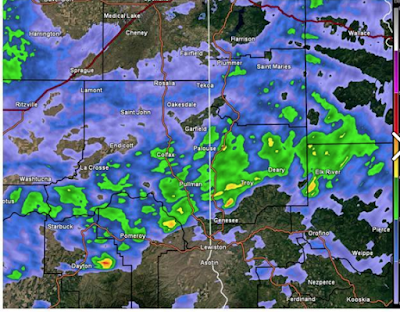
- Thunderstorms over the Palouse.
 |
| Radar image Saturday afternoon |
- First snowfall of the season above 5000 feet.
- Areas along the east side of the Cascades like Leavenworth, Plain, and Winthrop received over one inch of rain.
- Areas along the Cascades crest received 4+ inches of rain
- In the Idaho Panhandle and extreme Eastern Washington, areas received around a half to three quarters of an inch of rain.
 |
| 24-hour Precipitation ending 4am Sunday 1 Nov |
Sunday Nov 1
- The moisture associated with the atmospheric river begins to dip South and exit the region.
- The Idaho Panhandle received the most rain with most locations getting a quarter to half an inch of rain
 |
| 24-hour Precipitation ending 4am Monday 2 Nov |
- The Cascades and Northern Mountains experienced a drop temperatures and began to receive snow Sunday.
The total precipitation for the weekend was impressive, as expected. Some parts of the western Cascades picked up over 10" of moisture, while the Panhandle mountains generally received 3-5" of rainfall.
 |
| 7-day Precipitation ending 4am Tuesday 3 Nov |
Here's some weekend totals from the local area
Spokane: 0.61"
Coeur d'Alene: 0.88"
Lewiston: 0.43"
Wenatchee; 0.08"
Omak: 0.15"
Ephrata: 0.03"
Moses Lake: 0.08"
Pullman: 1.08"
Deer Park: 0.92"
Republic: 0.48"
Bonners Ferry: 1.13"


No comments:
Post a Comment