Friday, November 8, 2024

La Nina Update - Winter Outlook 2024-25

Have you been wondering what kind of winter the Inland NW will be granted with this year?  In this blog post we take a look at what a possible La Nina Winter will bring.

Our partners from the Climate Prediction Center wrote a fantastic blog about the influence of La Nina on snowfall across the region, that we highly recommend checking out.  The link to their blog can be found here.

As the blog states, for La Nina winters there is a tendency for above normal snowfall.  Indeed, local research we've conducted for several cities across our region show a tendency for above normal snowfall.  As shown below, on average snowfall ranges from 110-125% of normal for La Nina Winters.

% of normal snowfall for all La Nina winters from 1950-2017

For the interactive version of this map, where you can view charts for individual locations, click here.  Unfortunately the map isn't mobile friendly, so it is best viewed from a computer.

The latest probability for a La Nina this winter is around 70% according to the chart below.

% chance of La Nina (blue), Neutral (gray), El Nino (red) for each 3 month period.  DJF would be the chances for this upcoming winter

What do some of the latest climate models suggest for the winter?  The NMME (North American Multi-Model Ensemble) shows what one would typically expect for La Nina, cooler and wetter than normal conditions for the northwest.

NMME temperature and precipitation anomaly forecast for Dec 2024-Feb 2025


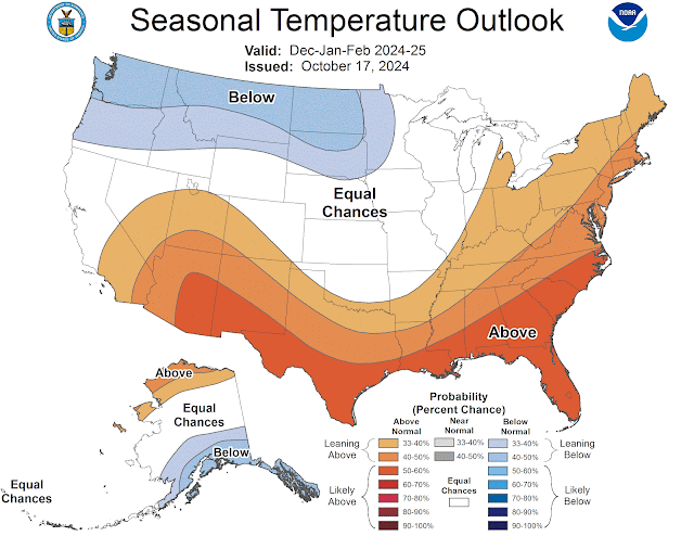
What about the official outlooks from the Climate Prediction Center?  These are weighted towards cooler and wetter than normal as well.

CPC Temperature Outlook valid Dec 2024 - Feb 2025

CPC Precipitation Outlook Valid Dec 2024 - Feb 2025


We have said this in previous blogs and will say it again in this one.  La Nina is only one piece of the puzzle, and while the outlooks favor increased odds for above normal snow, it is certainly not a guarantee.  This is because other oscillations in the atmosphere impact the weather pattern that sets up.  For instance, take a look at Spokane snowfall for all La Nina Winters since 2000.


My oh my!  Anywhere from 27"-98"!  And interestingly, those two winters (2005/06 and 2008/09) were both weak La Nina events.  So, while the average La Nina snowfall for Spokane is between 55-60", the precise number Spokane ends up with this winter may be much higher or lower.  

But given that a weak La Nina is favored and latest outlooks side towards the cooler and wetter, it would be best to prepare now if you haven't already.


No comments:

Post a Comment