In our last blog entry, we were stuck in a dry ridge of high pressure in mid January, wondering if winter was over. The computers were giving hints that the pattern would change right around the time the calendar changed from January to February. And that actually panned out. This was quite impressive for a 10 to 14 day forecast. The problem is, the "cold snap" of early February only lasted a whopping 2 days. (The blue bars in the image below show the daily high and low temperature. Blue bars below the brown shading are below normal temperatures).


The GEFS model has actually been showing this pattern shift for a few days now. Additionally, the European model has been doing the same. So there's a small amount of confidence that we could see stormier weather return by the last week of February. But forecasting the weather 3 weeks in advance is risky business.
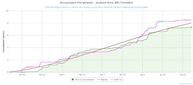
All of this brings up the question: is our recent dry spell leading us back into a drought? Here's the accumulated precipitation for Spokane since October 1st. The brown line is what our precipitation should look like in an average year. The green line and shading shows our precipitation for this winter.
You can see that we started off dry in October (green line is lower than the brown line). But then we quickly caught up to normal and we were actually wetter than normal in November (green line is above the brown line). Then our mild December dropped us back onto the dry side. But our stormy weather after New Year's brought us back to normal. Unfortunately, we've fallen behind again in the past 3 weeks. Mind you, we're only 0.7" below normal, and we can make that up in a hurry. But as we just showed you, we're probably not going to see much precipitation for the next 3 weeks. By then our precipitation deficit will probably be about 1.5".
The image below is the same as what we were just looking at, except we've added the precipitation trace for the previous winter (2020-21) in purple. It's sort of scary how similar it is to our current winter. And we all remember how dry things were around here last spring and summer.
At this point in the winter, our mountain snow pack is looking good; right about where it should be (green colors indicates snowpack is normal). Of course, we'll see these number drop a bit as we go through these next 3 dry weeks.

Looking farther into the spring, the average of the climate models expect cooler-than-normal temperatures for the Northwest US February-April.


This pattern is consistent with what we usually see for La Nina during the spring. Obviously last year's La Nina didn't live up to those expectations. We'll see how this La Nina round #2 fares.
No comments:
Post a Comment