It is that time of the year when many residents of the Inland Northwest are asking "Will we have a White Christmas this year?" In this blog we will dig into the details, and try and answer this important question.
We must first begin with what our climate has to say about the chances. NCEI recently released an updated map based off 1991-2020 data. This is the odds of a White Christmas based simply off historic odds.

On average, areas near the Cascades, northern WA, and the Idaho Panhandle have a White Christmas. Spokane odds are close to 50%, while the odds drop off further as you head south into the Tri-Cities area and Lewiston area.
But what about this year? For it to officially be declared a White Christmas, the snow depth on the ground needs to be 1" or greater. So let's begin with what is on the ground now from our dedicated CoCoRaHS observers.
 |
| Snow depth reported from CoCoRaHS observers on Dec 17th, 2021 |
According to the map snow is covering the ground over many areas that already have good chances for a White Christmas.
So what does the weather look like as head into Christmas Day? An active weather pattern as a strong blocking upper ridge sets up near the Aleutian Islands and a deep trough over western North America and the northwest US.
 |
| 12z/Dec 17th GEFS 500mb heights and anomalies (shaded) valid Dec 18-25th, 2021 |
Multiple weather systems moving through the region will produce precipitation. Here is what the model shows for total precipitation through December 25th.


This is a tougher call for these two locations. Rapid warmup into Saturday, then temperature hovering around the freezing mark through Christmas. This suggest a mix of rain and snow may fall through the period. But with several opportunities for precipitation and temperatures cold enough for snow most of the time, odds are looking favorable for a White Christmas.

After a period of above freezing temperatures on Saturday, it looks like temperatures will hover near or below freezing through much of next week. White Christmas chances are looking high.
 As you can see, temperatures are forecast to be near or above freezing for much of next week, so there is more uncertainty of a White Christmas.
 |
| 12z/Dec 17th GEFS total precipitation (inches) from Dec 17-25th, 2021 |
Note that one of the wettest area through Christmas Day over the United States is over Washington, North Idaho, Oregon, and California.
But this is just precipitation. Since the pattern looks wet, the real question about White Christmas chances this year will come down to temperature. Will precipitation fall as rain, snow, or a mixed bag? Let's look at the temperature anomalies through the period beginning Saturday.
 |
| 12z/Dec 17th GEFS forecast of 2 meter temperature anomaly (degrees C) from Dec 18-25th, 2021 |
Note that as we go into next week, there is a growing area of cold air over Canada, but it looks like much of this arctic air will stay north of our area (at least through Christmas). For our region there are some warmer temperatures over southern WA into the Lewiston area on Saturday, but these diminish with no strong anomalies next week (close to normal temps for late December).
But an anomaly doesn't tell us much about if precipitation will fall as rain or snow. For example for some of our colder spots (Methow Valley), warmer than normal temperatures will still lead to snow most of the time in late December. So let's dig a little deeper.
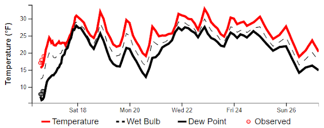
Here we will show an ensemble system (National Blend of Models) which shows forecast temperatures for several cities through next week. This method has proven to be more skillful than using just one model forecast. The red line is temperature. Also note these temperature forecasts are the average from a variety of weather models and ensemble systems, and don't reflect uncertainty in the numbers which tends to increase with time, especially in the day 5 and beyond time frame.
We will work our way from north to south. Let's begin with Sandpoint and Omak.
Sandpoint
Omak
With many areas already having snow on the ground, and a high likelihood for more, White Christmas chances are looking good.
Now let's move south, looking at Wenatchee, Moses Lake, and Spokane Valley.
Wenatchee
For Wenatchee, temperatures near or below freezing and more snow opportunities the odds are looking good for a White Christmas as well.
Moses Lake
Spokane (Felts Fields Forecast)
This is a tougher call for these two locations. Rapid warmup into Saturday, then temperature hovering around the freezing mark through Christmas. This suggest a mix of rain and snow may fall through the period. But with several opportunities for precipitation and temperatures cold enough for snow most of the time, odds are looking favorable for a White Christmas.
Let's go further south and take a look at Pullman and Lewiston.
Pullman
After a period of above freezing temperatures on Saturday, it looks like temperatures will hover near or below freezing through much of next week. White Christmas chances are looking high.
Now one of the trickier spots, Lewiston.
Lewiston
In summary, odds of a White Christmas are looking higher than historical odds this year. Most areas should have a White Christmas, with the Lewiston area having the highest uncertainty.
No comments:
Post a Comment