Our next weather system to move into the Inland Northwest will come late this weekend. Leading up to that storm system, however, will be more seasonal or warmer than normal weather for this time of year. Let’s look at the details of what to expect going into this weekend.
First, a warm up
Spokane’s normal high and low temperatures are 53°F and 34°F, respectively.
The forecast temperatures for the weekend, Friday, Saturday, and Sunday, are only going to warm each day with Sunday looking to be the warmest of this stretch of days, topping out in the low to mid 60s.

500mb height chart (above) from the GFS showing the ridge of high pressure building off the northern California coast. This will lead to warmer temperatures through the weekend in the Northwest part of the country.
Then, strong winds
The next cold front arrives late Sunday night with a trough passage. This cold front will move through rather quickly and bring precipitation with it beginning across western Washington earlier on Sunday. By Sunday afternoon, we’ll start seeing rain/snow showers moving up and over the Cascades and beginning to fill in across far eastern, southeastern Washington and northern Idaho. Oftentimes when a weather system is oriented due west, the Cascades tend to “shadow” most of the precipitation from spilling over into eastern Washington. So, most places east of the Cascades may be shadowed for precipitation, except in far eastern Washington along the Idaho border and in north-central Idaho where rain and snow chances are more likely. As for snow for this cold front, the Cascade passes will see moderate to heavy snow Sunday through Monday. What is moderate snow? Well, we're thinking about a foot of snow to some of the Cascade Passes and about 4 - 6 inches in some of the Idaho Panhandle mountains.
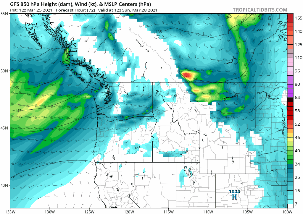
This is the GFS forecast model of wind speed at 850mb with surface pressure centers (notice the red Low moving through Canada).
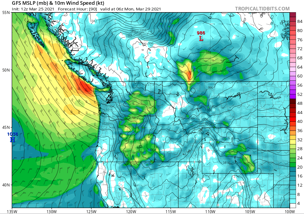
These are winds at about 4500 MSL which is about 2000-3000 feet above the ground for the Inland Northwest. The loop (above) goes from 5 am Sunday through 11 am Monday. If we take a look at just a snapshot during this time and zoom down to the surface (image below) we see that the surface low pressure begins to intensify over Alberta by late Sunday night and the west-southwest winds across the Columbia Basin and the Palouse begin ramping up (greens and blues = 20-30 mph sustained winds).
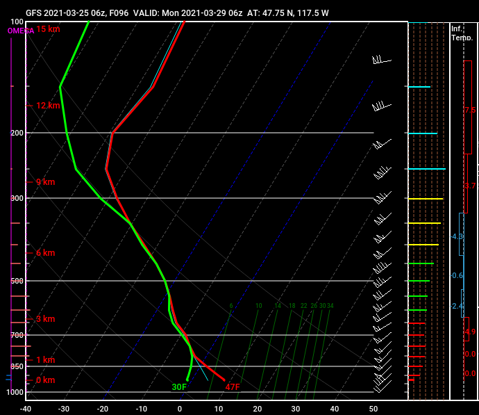
The ability for stronger winds above the surface to mix down to the surface Sunday night into early Monday morning looks decent at several locations across the Columbia Basin. From Moses Lake to Spokane to Coeur d’Alene and into the northern Idaho Panhandle, an unstable layer (better for mixing) rises from the surface to about 3500-4000 feet above the surface. The image below is a forecast sounding for late Sunday night which paints a picture of what the environment might look like. Where the red and green lines meet just above the surface (bottom) is where the environment becomes more stable and therefore not as easily able to mix down those stronger winds.
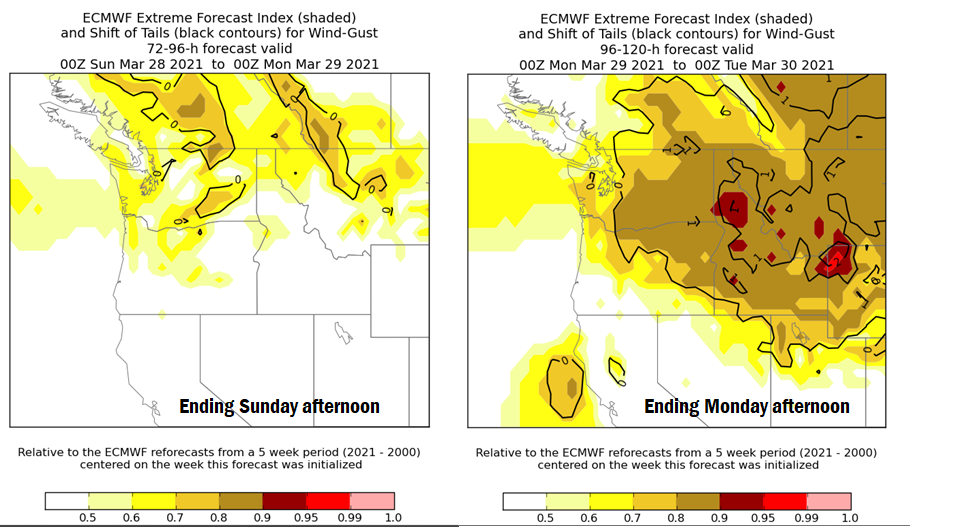
If we look at the European model extreme forecast index for wind gusts for Sunday and Monday we see where the forecast model is hinting at a weather event unfolding that is outside the climatology dataset for a period of time surrounding this date. When we see values greater than 0.8 and even greater than 0.9 we take this to mean a significant event is likely to occur.
And finally, a sharp cool down
Behind the cold front Monday we will see a pretty sharp drop in temperatures. Sunday we will see daytime high temperatures in the upper 50s and even some low 60s and Monday we may only top out in the mid 40s with overnight lows trending below freezing in the mid to upper 20s through mid-week. Nothing like a potent Spring storm to knock the feel of winter back in briefly! The images below show the daytime high temperature forecast for Sunday afternoon and then Monday afternoon after the front has moved through.
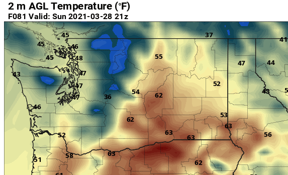
One model’s depiction of the forecast high temperatures Sunday.

And the forecast high temperatures Monday.
No comments:
Post a Comment