Timing
The tricky part of this forecast is snow accumulations as temperatures in many areas will be hovering near the freezing mark. Will get more into this in a little bit, so let's talk timing of rain and snow.
 |
| 12z Nov 12th NAM 3 km model run of precipitation type/intensity |
The above animation reflects one model run, so actually timing and precipitation type may vary. As you can see, most areas across northern Washington into the Idaho Panhandle will see snow, as well as the palouse. Also note the snow for the morning commute for much of NE Washington and North Idaho. Allow extra time for your morning commute.
The I-90 corridor from Moses Lake to Ritzville and areas south and east towards the Lewiston-Clarkston Valley should see mainly rain.
Snow Amounts
What about snow amounts? Models have trended towards increasing snow amounts. For example, here is a loop of the past three model morning runs from the UW WRF GFS.
 |
| UW WRF-GFS 24 hour snow accumulation forecast ending 4 PM PST Friday from three model runs since Tuesday, Nov 10th. |
At the top right of the image you will see the date the model was run (after Init:), with the latest run (Nov 12th being the last image). Legend of amounts is at the bottom. You can see the latest image has really increased the snow amounts across portions of Eastern Washington and north Idaho with 6+ inches in many areas even some localized amounts near a foot! But can we believe it?
Well, another model we look at, the European model, is hitting NE Washington and N Idaho with anomalous snow as noted by the light blue shading which would support the heavy snow threat.
Another way of looking at potential accumulations is through model ensemble forecasts. This is a model run multiple times just with slightly different initial conditions to give us a better idea of uncertainty in the forecast. As you'll see below Spokane carries high uncertainty with a large spread in snow amounts while Pullman carries greater confidence 2-3".
 |
| 15z Nov 12th SREF Model forecast of snowfall for Spokane Airport and Pullman through 4 PM PST Friday |
Here is our snow forecast as of Thursday afternoon:
 |
| NWS Snowfall forecast issued 230 PM PST November 12th, 2020 valid 4 PM Nov 12- 4 PM Nov 13 |
Reminder, the NWS will continue to evaluate the snow forecast and these values may change. For the latest forecast for your area, go to our web page weather.gov/spokane for the latest forecasts.
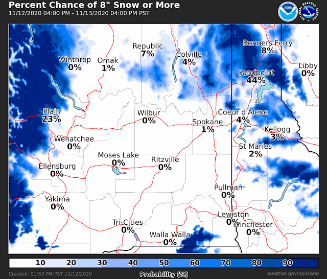
Here is some additional snowfall probabilistic guidance we receive at the NWS based on multiple model/ensemble forecasts. Here is what they are showing for chances of exceeding these thresholds:
2" or more
4" or more
8" or more
The snow we get will endure some melting in the afternoon, with high temperatures warming into the upper 30s to low 40s in many valleys.
In summary, get ready for more snow. Most areas across northern Washington into the Idaho Panhandle will see snow, as well as the palouse. Also note the snow for the morning commute for much of NE Washington and North Idaho. Allow extra time for your morning commute.


No comments:
Post a Comment