What a wet October!
As most of you already know, October will go down in the record books. In this blog we will talk about records, what caused it, and then take a look ahead as some may be wondering when it will snow.
So why was October so wet? Let's first take a look at what usually happens in October by analyzing the jet stream. The jet stream is a current of fast moving winds that transport weather systems across the globe. Where is this jet stream typically in October?
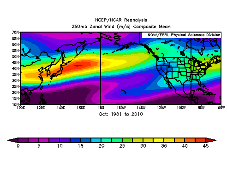 |
| October 1981-2010 250mb jet mean |
| October 2016 250mb jet mean |
What else caused the wet pattern?
 |
| Typhoon Songda |
We often don't think of Typhoon's when it comes to the weather over our region. But in October sometimes these tropical system's can get embedded within the jet stream as they leave the tropics and re-curve into the mid-latitudes. This is exactly what happened with Typhoon Songda (pictures above), reaching the area October 15th. The remnants of the Typhoon got picked up by the jet stream with the low center tracking over Vancouver Island.
 |
These are the main reasons for the wet October, now let's get to the records! These were not just over our area, but much of the west coast of North America. Check this out!
 |
| Tweet from WRCC showing October precipitation records |
This was a tweet sent out by the Western Region Climate Center (WRCC) back on Nov 1st. Because of the southward adjustment in the jet stream that persisted during the month, areas across northern British Columbia and SE Alaska recorded the driest October on record.
So what areas specifically had the wettest on record? Take a look...
So what areas specifically had the wettest on record? Take a look...

So how much rain fell? Here is a monthly analysis which takes into account observational data and provides an upward adjustment in the mountains.
 |
| Precipitation analysis from October 2016 |
Looking at the legend on the right side, anything in white is 20+ inches, pink and purple 10-20", red colors 5-10", brown and orange 3-5", with yellow around 3". Here are some of the top wettest reports from our area.

A special thanks to all of our spotters, COOP observers, and CoCoRaHS observers for all the reports you send to us, we appreciate it!
Now finally, the most impressive record broke in October was Spokane.

As you can see, October 2016 for Spokane was the wettest month of all time, dating back to 1881.
We have talked a lot about rain, some of you may be asking when will it snow? Well as usual this depends on where you live. The tables below summarize when the normal first inch of snow occurs in no particular order.


Of course each year is different. It looks like the first half of November is going to be very mild with temperatures above normal. Here is the 8-14 day outlooks valid Nov 11-17th issued by the Climate Prediction Center on Nov 3rd.
 |
| CPC 8-14 day temperature outlook issued Nov 3rd |
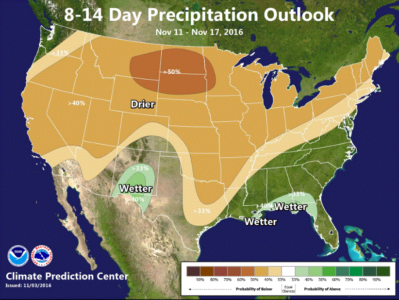 |
| CPC 8-14 day precipitation outlook issued Nov 3rd |
This does not look favorable for valley snow. We will have to wait and see if the pattern changes towards the end of the month.
Thanks for your great information, as usual, Rex! As a CoCoRAHS volunteer in Nelson, BC (150 miles due north of Spokane and about 40 north of the border), my gauge had (Oct. 2 morning report to Nov. 1 report) 7.06 inches (179.3 mm or 17.9 cm).
ReplyDelete