As mentioned in a September blog, here, every El Nino year is different, and this winter has been no exception. We currently have one of the strongest El Nino episodes on record. Here is a look at the SST anomalies over the past month along the equator.
Note on the map the large area of warm Sea Surface Temperature (SST) anomalies of 2-3 degrees C over the Central and Eastern Pacific Ocean along the Equator. The current strength is threatening the 1997-1998 event which was the strongest El Nino since 1950 based on the SST anomalies. Strong El Nino episodes tend to bring a wide range of winter precipitation to the Inland NW with milder conditions. So what did December bring? You probably already know, but it was wet! Take a look at the percent of normal precipitation map below.
Washington, Oregon, Idaho, and western Montana saw about double the amount of normal precipitation, while southern California was dry.
This changed during the first 11 days of January.
Drier conditions for our region, while southern California got some much needed rain.
So what is causing all of this? As always, several factors come into play. El Nino is not the only player and other atmospheric variables come into play. This year the Arctic Oscillation (AO) has been active. Take a look at the chart below.
The AO turned strongly positive in late December and has since gone strongly negative over the past week as indicated by the solid black line. So what does this all mean? Let's begin with the positive phase.
During the positive phase, lower than normal pressure occurs over the arctic regions which tends to lead to an enhanced jet stream across the Pacific Ocean. This likely factored in to our very wet December.
So, now that we are in the negative phase, what does this mean?
The opposite occurs with higher than normal pressure over the arctic regions. Colder air often gets displaced south over the central and eastern US and this is true for this episode with very cold temperatures over the upper Midwest and northeast. This may have contributed to our drier spell in the beginning of January.
So what lies ahead? Several more storms are on the way.
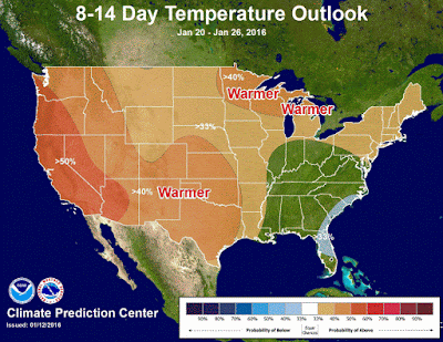
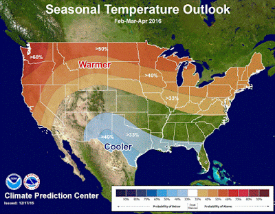
The outlooks call for increased odds of wetter and warmer than normal conditions. What about after that? Typically an El Nino like pattern is most prevalent during the later half of the winter into the spring. Thus, drier and warmer than normal conditions will become increasingly favored, here is the latest seasonal outlook for February, March, and April from the Climate Prediction Center.
The wet weather has been welcome and has brought a significant improvement or end to the drought over Washington and north Idaho.
This is welcome news to our region since we could see drier than normal conditions develop in February, March, and April.


Thanks. That was a cool blog.
ReplyDelete