First, let's start with the current situation. The warm and wet weather so far this month gave us a respectable mountain snow pack, but left the lower elevations with very little snow. About the only exception to this is in the Cascade valleys and the Waterville Plateau. Here's an analysis of snow on the ground:
As you can see, not very Christmas-like for much of the populated areas. Just for comparison, here's the morning satellite image:
 |
| MODIS satellite image for 15 Dec 2015 |
It's hard to tell the difference between the clouds and the snow. The white areas that have a herring-bone appearance are clouds. But you can definitely see snow on the Waterville Plateau. They're looking good for a White Christmas.
So what about the rest of us? Is there any hope? Yes, and not from just one storm. There's actually a series of weather systems during the next 7-9 days that could bring us snow. The first is tonight. Here's the forecast of snowfall:
OK, so it's nothing to write home about. The system is a rather weak one, coming at us from the north. This flow pattern favors locations south and east of Spokane. Here's what it looks like on satellite:
 |
| IR Satellite image 15 Dec 2015 |
The lack of clouds over British Columbia shows how weak tonight's event is. The bigger storm just off the Pac NW coast will dive into California, missing us. But the one behind it (on the left side of the image) will arrive on Thursday for a good chance of snow. Here's the expected snow totals from that storm:
Definitely a more respectable storm, and probably the first significant snow for most residents. Will it last for a week? For the Palouse and L-C valley, it might not survive the day. Here's the Friday afternoon high temperatures:
Temperatures around 40 along with some afternoon wind could melt most if not all the snow for Lewiston, Pullman, and Ritzville. But don't fear. There are still more opportunities for snow. The reason is that the overall weather pattern will be changing. Gone will be our warm and moist flow from the southwest. Instead we'll be getting air from the Gulf of Alaska.
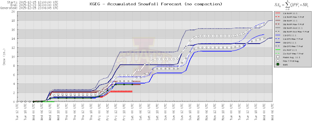
As we get farther out in time, the details are typically in doubt. Rather than show you a bunch more maps, let's look at a computer snowfall forecast for Spokane.
You can see the first "bump" of snowfall (on the left side of the graph) will bring 1-2" of snow (probably closer to 1"). The 2nd bump on Thursday night and Friday shows another 3-5" of snow. Then there's another system on Sunday, and yet another possibly next Tuesday.
Now, don't go thinking we're going to have 14-18" of snow on the ground by next Wednesday. Even if (and that's a big "if") we get all of the snow from these 4 storms that the computer is predicting, it doesn't account for melting and compaction. However, all that said, there is a good chance that by next Wednesday, most locations will have at least some snow on the ground. How much remains to be seen.
By the way, if you like White Christmases, be thankful this year that you live in the West. Our friends in the East will be celebrating the holiday week in their shorts. The trough of low pressure over the western US means a warm ridge of high pressure in the East. Here's the forecast for next week's temperatures:
You don't typically see probabilities that high. Above normal temperatures east of the Mississippi next week are a done deal. Here's the precipitation outlook:
Wet in the West and the Ohio valley. While we're getting snow next week, the Southeast and Gulf Coast will be getting thunderstorms.
Buffalo, NY still is waiting for their first 0.1" of snow of the season, the latest that it's ever taken.
Oh, if you're wondering what the historical probability of a location seeing a White Christmas, NCDC has a story on that at: https://www.climate.gov/news-features/featured-images/are-you-dreaming-white-christmas
Here's their results:
We'll update this blog in a few days to see if we're still looking at a White Christmas.


Very interesting El Nino winter so far.No indication yet of the blocking ridge that usually sets up over the NW that weakens or diverts fronts to the south.Instead,a much more active and progressive weather pattern than we would experience in a typical El Nino winter.
ReplyDeleteThis December will probably end up as one of the warmest ever across the continental U.S..Double digit temperature departures over a wide area so far.Even if we experience normal temps for the rest of the month,this month will end up 4 degrees above normal in Spokane.It will be interesting to see if the rest of the winter is of the relatively mild,dry,and dull variety usually associated with El Nino,or instead,uniquely different.
Just found your blog. Thanks for the cool posts!
ReplyDeleteJohn