Wednesday, October 28, 2015

The start of the Wet Season

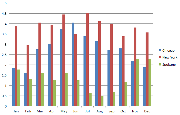
The bar graph below shows the average precipitation for Chicago, New York, and Spokane.


Much of the U.S has the majority of their precipitation in the summer (Chicago), or it's fairly evenly distributed throughout the year (New York).  In the West, it's the other way around. We have a distinct dry season in the summer, and wet season in the winter. 

After the hot dry summer, Pacific storms in September and October typically become more frequent, and increasingly wet.  And then in November, the storm door really opens; it's twice as wet as October.  In fact, for most of the Inland Northwest, November is the wettest month, followed closely by December and January.  (The exception to this is Lewiston, which has it's wettest month in May).  

This year, the storm door looks like it will open rather suddenly.  The storms for October have been fairly weak and temperatures have been near record warmth.  But all of that will change this weekend.  Below is the forecast rainfall for the next 5 days from 2 forecast models, the GFS and Canadian.


GFS Predicted Precipitation Oct 29 - Nov 2 2015


Canadian predicted precipitation 29 Oct - 2 Nov 2015


Now, before you go thinking that Wenatchee is going to get 0.5" to 1" of rain, or Spokane is going to 2" of rain, these models are notorious for spreading the rain too far away from the mountains into the lower elevations.  They know that the Mountains exist, but they don't have enough resolution to account for just how sharp the rain shadow is.  

The weather pattern that's going to bring us all this rain is a strong jet stream from west to east.  That kind of pattern produces a large rain shadow east of the Cascades, that extends at times all the way to Coeur d'Alene.  So for the area from Wenatchee to Spokane to Lewiston, take those computer forecasts and cut them in half, and you're probably in the ball park of what will happen.  For the Cascades and Panhandle mountains, the computer forecasts are probably a bit too low.  In other words, the western Cascades could see a foot of rain by Monday morning, and the Panhandle Mountains could see 6" or so.  That's a really nice start to the wet season.

This weather pattern is also a windy one.  Here's the wind gust forecast for Saturday afternoon.


One other thing.  These weather patterns are usually quite mild.  This will mean high snow levels.  They'll start off around 6,000 feet, and then rise to 8,000 feet on Friday and Saturday.  So this won't start building a mountain snow pack.  Yet.  

Colder air moves into the area on Sunday.  Snow levels will be dropping through the day, so that by the evening they'll be 4,000-5,000 feet.  Unfortunately, this will be as the precipitation is ending.  Still, there's a good chance for the mountains to pick up a few inches.  Here's the average computer forecast for mountain snowfall Sunday and Monday.  


OK, it's not enough to ski on, but it's a start.  The cooler air will stick around through much of the week, so any snow that does fall in the mountains won't be going anywhere. Here's the computer temperature forecasts for the next 7 days in Spokane.  Notice that next week, high temperatures will be in the mid-40s.


In fact, many locations will see their first freezing temperatures of the season by Tuesday or Wednesday morning.  This weather pattern won't change for awhile.  Here's the 8-14 day temperature outlook.

This shows below-normal temperatures in the West, with a good chance of above-normal temperatures in the East.  So a rather cool start to November.


Saturday, October 3, 2015

Is the end of fire season expected soon?

So while we can't argue that the worst of fire season is behind us, it should be noted there are still fires burning across portions of the Inland Northwest. Here's is what satellite information was showing on the last day of September:

MODIS Visible Satellite Imagery from 9/30/15

While these fires are far from the raging infernos we saw earlier this summer, it's still rather impressive for the end of September or beginning of October.  However, as we all know this year is different. First off, look at these precipitation totals since the beginning of April

Idaho Precipitation % of normal 4/2/15-10/1/15

Washington Precipitation % of normal 4/2/15-10/1/15
That is a lot of red and dark red shading over the Inland Northwest which correlates with meager precipitation amounts ranging 25-70% of normal. That's pretty dry. In fact, since the beginning of April through the beginning of October it was the driest period on record for both Spokane and Boundary Dam, WA (extreme NE corner of the state).

So combine the record dry conditions with nearly record warmth for both sites and it is no wonder the fire season has been so long. Here is a look at the temperatures for both sites.

So obviously record warm and dry conditions led to our active fire season, but unlike a typical year, things just aren't winding down as quickly as we are accustomed to. Climatologically, the days of active fires will be limited. We say that because the shorter days are leading to cooler temperatures and higher relative humidity levels  (both items are generally detrimental to good fire growth) while the chances for measurable precipitation are rising quickly. Climatologically the chance of measurable rain ranges from 20-25% over locations where the fires are currently burning. However by the end of the month those chances nearly double. So despite these facts, look at the latest fire danger ratings for the Inland Northwest:

Current Fire danger ratings
That map shows the fire danger is still high (yellow) or even very high (orange) across a sizable portion of the Inland Northwest, with moderate conditions (light green) found everywhere east of the Cascades. So what does that mean? According to the Wildland Fire Assessment System (WFAS) a high fire danger means, "All fine dead fuels ignite readily and fires start easily from most causes. Unattended brush and campfires are likely to escape. Fires spread rapidly and short-distance spotting is common. High-intensity burning may develop on slopes or in concentrations of fine fuels. Fires may become serious and their control difficult unless they are attacked successfully while small.

So is this danger level unusual for the beginning of October? Since 2006 (earliest year of  the graphical archive), the current fire danger has only been matched one time. That was in 2012. All other years saw low to moderate fire danger ratings across the area.


So what was the fire weather like in 2012? This satellite picture tells the story

MODIS Satellite imagery from 10/4/12

Just like this year, there were quite a few fires burning during the beginning of October. In fact, based on the satellite image, they were much bigger and included the Wenatchee Complex (southwest of Wenatchee) and the St. Mary's Misson Rd fire south of Omak. So what happened that year? The dry weather and fires continued to burn through the middle of the month, but several days of rain (not necessarily heavy) and cooler temperatures put an end to that fire season.

So what did the weather pattern look like for the end of that fire season? Well leading up to the end of the fire season, the upper-level pattern exhibited a large ridge parked right off the BC/WA coast with dry northwest flow over the region. Also, note the low-pressure area off the California Coast.

Early October 2012 500 mb pattern. 
So how does the pattern look for most of this week? Although it's far from identical, it does have some similarities, including the low near California, and the ridge over the Pacific Northwest.
500 mb pattern for Monday afternoon (10/5/15)
So what did the weather pattern that led to the end of the fire weather year in 2012 look like? The ridge broke down quite quickly and was replaced swift southwest flow into the Pacific Northwest and a deep low over the Gulf of Alaska. Again this brought cooler temperatures, periods of light rain (moderate in places), as well as significant cloud cover.
Mid-October 2012 500 mb pattern (Oct12-14)
How about this year? Is anything similar expected? Again although not a perfect match, there are some good similarities including a deep Gulf of Alaska low and deep southwest flow pointed into the Pacific Northwest from the eastern Pacific.
500 mb forecast for Oct 10, 2015
So how is our confidence in this solution and will this be the end of the fire season?  There are a few additional tools we can look at. One of the more interesting ones is called the NOMADS ensemble probability tool. This tool queries 21 GFS ensemble members or model runs and calculates the chances of any given parameter. Using this tool we can look at things such as what is our chance of seeing over a tenth of an inch of rain in a day?  When asking that particular question, here is the answer for the Grizzly Complex located over northern Shoshone County, ID.

The probability of seeing 0.10" of rain or more in 24 hrs over northern Shoshone County. 
So if you key in on the clustering of the blue bars, you can see that there is some consensus that by next weekend (10/10 and 10/11) that the weather pattern will support an increasing chance of rain (it peaks at 25% for the 24 hrs between 5pm Saturday through 5pm Sunday). Notice also that there is a small chance of light rain during the middle of the week.

Stay tuned and we shall see if this will truly be the end of a historically warm and dry fire season across the Inland Northwest.