The February 6th "Milky Rain"
**** Updated on 9 February with additional information at the end of post ****
A Possible Explanation
A highly unusual "milky rain" occurred over much of eastern Washington and Northeast Oregon on Friday, February 6th. Periods of light rain during the morning and afternoon left cars spotted and smeared with a white or grey residue.
 Picture from a Facebook Friend of the NWS Pendleton OR
 Picture taken at the NWS Spokane office
 Picture taken at the NWS Spokane office
It is not unusual to experience "muddy rain" in the Inland Northwest. During the summer months, dirty brown water marks are frequently deposited on our cars. However, muddy rains rarely occur in the winter. And why the unusual milky white color?
Most plausible explanation: A large dust storm in Northwest Nevada occurred Thursday night into Friday. The dust caused traffic accidents and poor visibility in the Reno area. Winds gusting in excess of 60 mph were reported across the northwest Nevada desert. Here are some peak wind gusts documented by the NWS office in Reno Thursday night into Friday.
WIND GUSTS
MONO AND EASTERN ALPINE COUNTIES
PERSHING...CHURCHILL...LYON AND MINERAL
COUNTIES
SURPRISE VALLEY AND NORTHERN WASHOE
COUNTY
TAHOE BASIN
WESTERN NEVADA SIERRA FRONT
Pay particular attention to the reports from Washoe, Humboldt, Pershing, Churchill, and Lyon counties. These generally sparsely populated counties are part of the "desert of Northwest Nevada" and are experiencing a multi-year drought. Numerous reports of blowing dust came from these counties Thursday night into Friday.

Check out some of the pictures from the Reno Gazette-Journal posted in a Saturday story about the storm that pounded the Sierra Mountains with snow and produced strong winds in western Nevada. Note the milky white or grey color of the blowing dust.
 Reno Gazette Journal
 Reno Gazette Journal
 Reno Gazette Journal
The white colored soil does not appear to be unique to a small area near Reno. Look at this Google Earth Satellite image. Dry lake beds appear bright white in the northwest Nevada desert and throughout the state.
 Google Earth Satellite Image
How does dust from as far away as Nevada get to northeast Oregon and eastern Washington? It would take many hours of a prolonged strong south wind to push dust that far. Below are some images from the University of Washington GFS MM5 weather model. These graphics are tough to read. Our apologies. We may be able to update these graphics with some better ones later.
The next two images are 850 millibar model wind and temperature forecasts. This is roughly 4700 feet above sea level. These images show a constant average wind of roughly 40 knots (46 mph) from 10 PM on Thursday to 7 AM on Friday. This is a period of 15 hours of a constant south wind at 4700 feet above sea level.

10 PM on Thursday: The small arrows on this graph show show south winds of 30-50 knots over the eastern half of Oregon

7 AM on Thursday: The small arrows on this graph show show south winds of 30-45 knots over the eastern half of Oregon and up to 50 knots in Washington.
A forecast sounding for John Day (central Oregon) at 4 AM from the University of Washington GFS MM5 shows the wind speed even stronger above 850 millibars...up to 60 knots (69 mph) out of the south/southwest.

How long would it take for dust to travel from northwest Nevada to the Inland Northwest? Gerlach, Nevada is near some of those dry lake beds in Nevada.
- Spokane to Gerlach: Distance - 490 miles
- 490 miles / 40 miles per hour = 12.25 hours
- 490 miles / 50 miles per hour = 9.8 hours
- Pasco to Gerlach: Distance - 380 miles
- 380 miles / 40 miles per hour = 9.5 hours
- 380 miles / 50 miles per hour = 7.6 hours
So, if dust were to arrive in the Inland Northwest by mid day Friday, we would expect it to originate in Nevada between midnight and 5 AM.
What time did the strong winds start in Nevada? The first wind damage reports started to come into the NWS Reno as early as 925 PM on Thursday night and continued through the night. Here is an excerpt from the Local Storm Report issued by the NWS Reno. High wind reports continued into Friday afternoon.
PRELIMINARY LOCAL STORM REPORT...SUMMARY
..TIME... ...EVENT... ...CITY LOCATION... ...LAT.LON...
0925 PM NON-TSTM WND GST 5 N RENO 39.61N 119.82W
A 73-MPH WIND
GUST WAS RECORDED AT THE NATIONAL WEATHER
1255 AM NON-TSTM WND DMG 2 SW SOUTH LAKE
TAHOE 38.92N 120.01W
12 INCH
DIAMETER TREE BLOWN DOWN.
1256 AM NON-TSTM WND GST 3 SSW SOUTH LAKE
TAHOE 38.90N 120.00W
0431 AM NON-TSTM WND DMG 2 ENE SOUTH LAKE
TAHOE 38.95N 119.95W
30 INCH
DIAMETER TREE BLOWN OVER.
0445 AM NON-TSTM WND DMG 4 SW SOUTH LAKE
TAHOE 38.90N 120.04W
6 TREES BLOWN
OVER.
0450 AM NON-TSTM WND GST 16 SSW RENO 39.32N 119.94W
A 134-MPH WIND GUST WAS RECORDED AT
THE TOP OF SLIDE
0545 AM NON-TSTM WND GST 5 WSW GARDNERVILLE 38.91N 119.83W
A TRAINED WEATHER SPOTTER REPORTED A
WIND GUST OF 70 MPH.
0550 AM NON-TSTM WND GST 9 SW RENO 39.45N 119.94W
AN 82-MPH WIND
GUST WAS RECORDED AT THE GALENA RAWS
Other explanations for the blowing dust have been "floating around". Excuse the pun. Here are a few of them.
Volcanic activity in Russia. Maybe, but concentrations of ash would probably be only trace amounts given the distance required to get here. You would also expect western Washington and western Oregon to have reports of "milky rain" in this scenario.
Ash from burn scars in the Western U.S. Another maybe. Burn scars are relatively small compared to the Nevada desert, so the source region would be limited. Burn scars in northern California, central Oregon and western Washington have received an abundance of moisture recently. Northwest Nevada has not. Soggy or snow covered ash will not blow around like dry ash or dust.
 Observed 60 Day Rainfall from water.weather.gov
 60 Day Percent of Normal Precipitation water.weather.gov
Additional Information on Monday, 9 Feb 2015
Some additional information has come into our office this morning which helps to shed some new light on this event. First, here's a detailed list of reports received at the NWS Pendleton office:
8 am NWS personnel notice dust hanging on the way to
Pasco. Call from Fossil about the dust hanging looks like fog.
8:18 Report and pic from Umapine
9:18 Report and pic from Milton Freewater
9:46 Pendleton office puts out a post
about being aware of the Milky Rain
10:01 Reports from Irrigon
10:04 Report from Dayton
10:09 Report from Tri-Cities
10:12 Report from Pendleton
10:18 Report from Walla Walla
10:19 Report from Helix
10:21 Report from Milton Freewater
10:23 Report from Walla Walla/Irrigon as
well
10:24 Report from Pasco
10:25 Report from Pendleton
10:32 Report and pic from Walla Walla
10:34 Report from Hermiston
10:35 Report from Kennewick… Report and
pic from Walla Walla
10:37 Report and pic from Richland
10:43 Report and pic from Kennewick
10:44 Report and pic from Milton Freewater
10:45 Report and pic from Walla Walla
10:52 Report from Richland
11:05 Report and pic from Tri-Cities
11:07 Report and pic from Walla Walla
11:08 Picture from Connell
11:13 Report and pic from Milton Freewater
11:15 in Hermiston
11:21 Pic from Richland
11:22 Report from Tri-Cities
11:26 Report from Spokane
11:27 Report and pic from Kennewick and
Finley
11:32 Report from Spokane
11:35 Report from Walla Walla and College
Place
11:38 Report from Dayton
11:39 Report from Kennewick
11:45 Report and pic from Irrigon
11:58 Report from Boardman
12:08 Report from Umatilla
12:16 Report from West Pasco
12:33 Report from Hermiston
12:43 Report and pic from Kennewick
12:47 Report from Spokane
12:51 Report from Richland
1:09 Report and pic from College Place
2:31 Report from Spokane
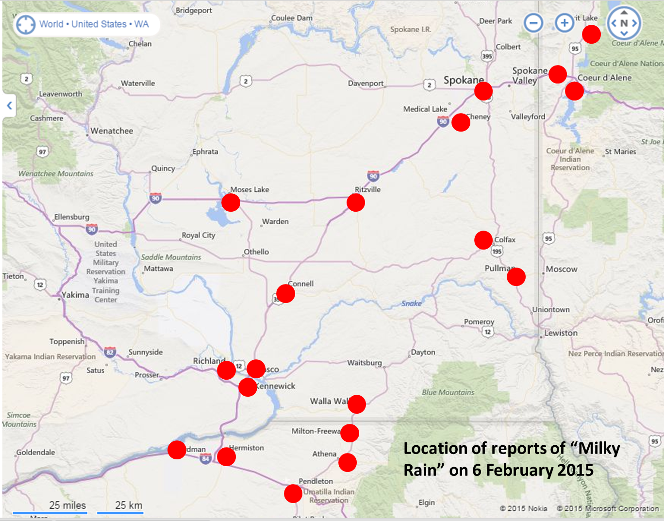
Here's a map showing the location of all of the reports we received.
There are air quality sensors run by the states of Washington and Oregon. These sensors measure particulate matter in the air. Here's the sensor readings from Tri-Cities and from Cheney (southwest of Spokane):


The TPM25 is for very small particulates (e.g. smoke). There isn't any perceptible difference in these readings at either site (dark green like). The TPM10 are for larger particulates, typically dust. At both sites, there was a noticeable increase in PM10 on February 6th. The PM10 readings started increasing around 7am and peaked midday, before decreasing in the afternoon. In both cases, the elevated PM10 lasted about 6-8 hours. This correlates well with the Milky Rain reports.
An additional piece of information is the weather observation at the Pendleton Airport. At 6am the visibility was reported to be only 4 miles due to Haze, without any rain or fog. The wind had been blowing from the south for the previous 7 hours, but the visibility didn't decrease until sunrise. In other words, whatever reduced the visibility was likely not being generated locally.
In yesterday's blog entry (above) it was speculated that the strong winds over northwest Nevada may caused a dust cloud which moved northward into eastern Washington/Oregon, and that dust might have been responsible for the "Milky Rain". Here's a display of the wind from the Cold Springs, Nevada area:

You can see from the sustained winds (red line) and gusts (green dots) that the wind started blowing around 5am (20-35 mph) and gusted to 62 mph around 7am Friday.
There is a weather computer program that allows us to enter a source location (e.g. smoke from a fire) and the program will predict where it will go. So we entered the location north of Reno that was mentioned in the Reno Gazette Journal. We told the computer to start at 7am February 5th and give us a forecast for each hour through 4pm. Here's the result of that forecast:

As you can see, this computer forecast model would predict that dust generated just north of Reno would have moved across extreme eastern Oregon and into western Montana. The forecast model would suggest that the dust would have traveled too far to the east to be observed in central Washington.
But the NWS Pendleton office also received a very valuable weather spotter report from south-central Oregon. They reported blowing dust from the alkali beds near Summer Lake. Here's a couple of pictures of Summer Lake, including one showing the alkali dust blowing:
.jpg)
Summer Lake, Oregon

Blowing Alkali Dust on Summer Lake, Oregon
And here's a view of Summer Lake on satellite:

Summer Lake, Oregon
There is a weather observation at this location. Here's the observed wind:

The wind was blowing around 20-30 mph with gusts 35-50 mph on the 5th of February. Then overnight the wind increased to around 35 mph with gusts 60-70 mph. These very strong winds lasted about 9 hours, similar to the Milky Rain duration.
So we ran the computer trajectory model from this location for the time of the strongest winds. Here was the resulting trajectory forecast:

These trajectories start at 10pm on the 5th and continue until 7am on the 6th. As you can see, the track of dust from this location would move directly over the Tri-Cities and Spokane areas. Additionally, the timing fits. The first trajectories arrive in the Pendleton area around sunrise on the 6th.
So, based on this additional data and analysis, it appears that dust from south-central Oregon near Summer Lake was lofted into the air by strong winds on the night of February 5th. A trajectory forecast model agrees that dust from this location would have traveled over the Pendleton, Tri-Cities, and Spokane areas on the morning of the 6th. It is worth noting that a large burn scar from the summer of 2014 is located in central Oregon. We cannot confirm or rule out that ash from this burn scar may have been a part of the Milky Rain.
If additional information comes to us, we will update this blog.
Here's some additional pictures from the NWS Pendleton office:


WIND GUSTS
LOCATION
REPORT
LASSEN...EASTERN PLUMAS AND EASTERN
SIERRA COUNTIES
JANESVILLE 62.00 MPH
SUSANVILLE 2 NE 66.00 MPH
ANTELOPE LAKE 5 NNW
70.00 MPH
PITTVILLE 17 S 73.00 MPH
HONEY LAKE 15 NE 77.00 MPH
DOYLE 3 N 79.00 MPH
SIERRAVILLE 8 SSE
93.00 MPH
MONO AND EASTERN ALPINE COUNTIES
MONO LAKE 1 NW 63.00 MPH
CROWLEY LAKE 5 W 76.00 MPH
COLEVILLE 3 E 82.00 MPH
BRIDGEPORT 4 WNW 91.00 MPH
PERSHING...CHURCHILL...LYON AND MINERAL
COUNTIES
SILVER SPRINGS AIRPORT 62.00 MPH
SMITH VALLEY 63.00 MPH
YERINGTON MUNICIPAL AIR 63.00 MPH
LOVELOCK DERBY 64.00 MPH
SWEETWATER SUMMIT 86.00 MPH
SURPRISE VALLEY AND NORTHERN WASHOE
COUNTY
FOX MOUNTAIN 12 WNW 60.00 MPH
LAKE CITY 3 ESE 70.00 MPH
TAHOE BASIN
SOUTH LAKE TAHOE 3 SSW
64.00 MPH
RENO 16 SSW 134 MPH
WESTERN NEVADA SIERRA FRONT
RENO 4 SE 58.00 MPH
GARDNERVILLE 4 S 59.00 MPH
MINDEN-TAHOE AIRPORT 64.00 MPH
COLD SPRINGS VALLEY 2 W
65.00 MPH
RENO 18 S 66.00 MPH
SPOONER SUMMIT 3 E
68.00 MPH
GARDNERVILLE 5 E 71.00 MPH
RENO 5 N 73.00 MPH
GARDNERVILLE 5 NNW 73.00 MPH
WASHOE CITY 2 WSW 77.00 MPH
NEW WASHOE CITY 3 SW
79.00 MPH
RENO 9 SW 82.00 MPH
VIRGINIA CITY 4 NNW
88.00 MPH
GARDNERVILLE 5 WSW 90.00 MPH
E GALENA 109 MPH
Pay particular attention to the reports from Washoe, Humboldt, Pershing, Churchill, and Lyon counties. These generally sparsely populated counties are part of the "desert of Northwest Nevada" and are experiencing a multi-year drought. Numerous reports of blowing dust came from these counties Thursday night into Friday.
Check out some of the pictures from the Reno Gazette-Journal posted in a Saturday story about the storm that pounded the Sierra Mountains with snow and produced strong winds in western Nevada. Note the milky white or grey color of the blowing dust.
Reno Gazette Journal
Reno Gazette Journal
Reno Gazette Journal
Google Earth Satellite Image
How does dust from as far away as Nevada get to northeast Oregon and eastern Washington? It would take many hours of a prolonged strong south wind to push dust that far. Below are some images from the University of Washington GFS MM5 weather model. These graphics are tough to read. Our apologies. We may be able to update these graphics with some better ones later.
The next two images are 850 millibar model wind and temperature forecasts. This is roughly 4700 feet above sea level. These images show a constant average wind of roughly 40 knots (46 mph) from 10 PM on Thursday to 7 AM on Friday. This is a period of 15 hours of a constant south wind at 4700 feet above sea level.
10 PM on Thursday: The small arrows on this graph show show south winds of 30-50 knots over the eastern half of Oregon
7 AM on Thursday: The small arrows on this graph show show south winds of 30-45 knots over the eastern half of Oregon and up to 50 knots in Washington.
A forecast sounding for John Day (central Oregon) at 4 AM from the University of Washington GFS MM5 shows the wind speed even stronger above 850 millibars...up to 60 knots (69 mph) out of the south/southwest.
How long would it take for dust to travel from northwest Nevada to the Inland Northwest? Gerlach, Nevada is near some of those dry lake beds in Nevada.
- Spokane to Gerlach: Distance - 490 miles
- 490 miles / 40 miles per hour = 12.25 hours
- 490 miles / 50 miles per hour = 9.8 hours
- Pasco to Gerlach: Distance - 380 miles
- 380 miles / 40 miles per hour = 9.5 hours
- 380 miles / 50 miles per hour = 7.6 hours
So, if dust were to arrive in the Inland Northwest by mid day Friday, we would expect it to originate in Nevada between midnight and 5 AM.
What time did the strong winds start in Nevada? The first wind damage reports started to come into the NWS Reno as early as 925 PM on Thursday night and continued through the night. Here is an excerpt from the Local Storm Report issued by the NWS Reno. High wind reports continued into Friday afternoon.
PRELIMINARY LOCAL STORM REPORT...SUMMARY
NATIONAL WEATHER SERVICE
RENO NV
1107 AM PST SAT FEB 07 2015
..TIME... ...EVENT... ...CITY LOCATION... ...LAT.LON...
..DATE... ....MAG.... ..COUNTY LOCATION..ST.. ...SOURCE....
..REMARKS..
0925 PM NON-TSTM WND GST 5 N RENO 39.61N 119.82W
02/05/2015 M73.00 MPH WASHOE NV OFFICIAL NWS OBS
A 73-MPH WIND
GUST WAS RECORDED AT THE NATIONAL WEATHER
SERVICE
FORECAST OFFICE IN NORTH RENO.
1255 AM NON-TSTM WND DMG 2 SW SOUTH LAKE
TAHOE 38.92N 120.01W
02/06/2015 EL DORADO CA
LAW ENFORCEMENT
12 INCH
DIAMETER TREE BLOWN DOWN.
1256 AM NON-TSTM WND GST 3 SSW SOUTH LAKE
TAHOE 38.90N 120.00W
02/06/2015 M64.00 MPH EL DORADO CA
ASOS
0431 AM NON-TSTM WND DMG 2 ENE SOUTH LAKE
TAHOE 38.95N 119.95W
02/06/2015 EL DORADO CA
LAW ENFORCEMENT
30 INCH
DIAMETER TREE BLOWN OVER.
0445 AM NON-TSTM WND DMG 4 SW SOUTH LAKE
TAHOE 38.90N 120.04W
02/06/2015 EL DORADO CA
LAW ENFORCEMENT
6 TREES BLOWN
OVER.
0450 AM NON-TSTM WND GST 16 SSW RENO 39.32N 119.94W
02/06/2015 M134 MPH WASHOE NV MESONET
A 134-MPH WIND GUST WAS RECORDED AT
THE TOP OF SLIDE
MOUNTAIN
SOUTHWEST OF RENO.
0545 AM NON-TSTM WND GST 5 WSW GARDNERVILLE 38.91N 119.83W
02/06/2015 M70.00 MPH DOUGLAS NV
TRAINED SPOTTER
A TRAINED WEATHER SPOTTER REPORTED A
WIND GUST OF 70 MPH.
0550 AM NON-TSTM WND GST 9 SW RENO 39.45N 119.94W
02/06/2015 M82.00 MPH WASHOE NV PARK/FOREST SRVC
AN 82-MPH WIND
GUST WAS RECORDED AT THE GALENA RAWS
SENSOR.
Other explanations for the blowing dust have been "floating around". Excuse the pun. Here are a few of them.
Volcanic activity in Russia. Maybe, but concentrations of ash would probably be only trace amounts given the distance required to get here. You would also expect western Washington and western Oregon to have reports of "milky rain" in this scenario.
Ash from burn scars in the Western U.S. Another maybe. Burn scars are relatively small compared to the Nevada desert, so the source region would be limited. Burn scars in northern California, central Oregon and western Washington have received an abundance of moisture recently. Northwest Nevada has not. Soggy or snow covered ash will not blow around like dry ash or dust.
Observed 60 Day Rainfall from water.weather.gov
60 Day Percent of Normal Precipitation water.weather.gov
Here's a map showing the location of all of the reports we received.
Additional Information on Monday, 9 Feb 2015
Some additional information has come into our office this morning which helps to shed some new light on this event. First, here's a detailed list of reports received at the NWS Pendleton office:
8 am NWS personnel notice dust hanging on the way to
Pasco. Call from Fossil about the dust hanging looks like fog.
8:18 Report and pic from Umapine
9:18 Report and pic from Milton Freewater
9:46 Pendleton office puts out a post
about being aware of the Milky Rain
10:01 Reports from Irrigon
10:04 Report from Dayton
10:09 Report from Tri-Cities
10:12 Report from Pendleton
10:18 Report from Walla Walla
10:19 Report from Helix
10:21 Report from Milton Freewater
10:23 Report from Walla Walla/Irrigon as
well
10:24 Report from Pasco
10:25 Report from Pendleton
10:32 Report and pic from Walla Walla
10:34 Report from Hermiston
10:35 Report from Kennewick… Report and
pic from Walla Walla
10:37 Report and pic from Richland
10:43 Report and pic from Kennewick
10:44 Report and pic from Milton Freewater
10:45 Report and pic from Walla Walla
10:52 Report from Richland
11:05 Report and pic from Tri-Cities
11:07 Report and pic from Walla Walla
11:08 Picture from Connell
11:13 Report and pic from Milton Freewater
11:15 in Hermiston
11:21 Pic from Richland
11:22 Report from Tri-Cities
11:26 Report from Spokane
11:27 Report and pic from Kennewick and
Finley
11:32 Report from Spokane
11:35 Report from Walla Walla and College
Place
11:38 Report from Dayton
11:39 Report from Kennewick
11:45 Report and pic from Irrigon
11:58 Report from Boardman
12:08 Report from Umatilla
12:16 Report from West Pasco
12:33 Report from Hermiston
12:43 Report and pic from Kennewick
12:47 Report from Spokane
12:51 Report from Richland
1:09 Report and pic from College Place
2:31 Report from Spokane
Here's a map showing the location of all of the reports we received.
There are air quality sensors run by the states of Washington and Oregon. These sensors measure particulate matter in the air. Here's the sensor readings from Tri-Cities and from Cheney (southwest of Spokane):
The TPM25 is for very small particulates (e.g. smoke). There isn't any perceptible difference in these readings at either site (dark green like). The TPM10 are for larger particulates, typically dust. At both sites, there was a noticeable increase in PM10 on February 6th. The PM10 readings started increasing around 7am and peaked midday, before decreasing in the afternoon. In both cases, the elevated PM10 lasted about 6-8 hours. This correlates well with the Milky Rain reports.
An additional piece of information is the weather observation at the Pendleton Airport. At 6am the visibility was reported to be only 4 miles due to Haze, without any rain or fog. The wind had been blowing from the south for the previous 7 hours, but the visibility didn't decrease until sunrise. In other words, whatever reduced the visibility was likely not being generated locally.
In yesterday's blog entry (above) it was speculated that the strong winds over northwest Nevada may caused a dust cloud which moved northward into eastern Washington/Oregon, and that dust might have been responsible for the "Milky Rain". Here's a display of the wind from the Cold Springs, Nevada area:
You can see from the sustained winds (red line) and gusts (green dots) that the wind started blowing around 5am (20-35 mph) and gusted to 62 mph around 7am Friday.
There is a weather computer program that allows us to enter a source location (e.g. smoke from a fire) and the program will predict where it will go. So we entered the location north of Reno that was mentioned in the Reno Gazette Journal. We told the computer to start at 7am February 5th and give us a forecast for each hour through 4pm. Here's the result of that forecast:
As you can see, this computer forecast model would predict that dust generated just north of Reno would have moved across extreme eastern Oregon and into western Montana. The forecast model would suggest that the dust would have traveled too far to the east to be observed in central Washington.
But the NWS Pendleton office also received a very valuable weather spotter report from south-central Oregon. They reported blowing dust from the alkali beds near Summer Lake. Here's a couple of pictures of Summer Lake, including one showing the alkali dust blowing:
And here's a view of Summer Lake on satellite:
There is a weather observation at this location. Here's the observed wind:
|
| Summer Lake, Oregon |
|
| Blowing Alkali Dust on Summer Lake, Oregon |
And here's a view of Summer Lake on satellite:
|
| Summer Lake, Oregon |
There is a weather observation at this location. Here's the observed wind:
The wind was blowing around 20-30 mph with gusts 35-50 mph on the 5th of February. Then overnight the wind increased to around 35 mph with gusts 60-70 mph. These very strong winds lasted about 9 hours, similar to the Milky Rain duration.
So we ran the computer trajectory model from this location for the time of the strongest winds. Here was the resulting trajectory forecast:
These trajectories start at 10pm on the 5th and continue until 7am on the 6th. As you can see, the track of dust from this location would move directly over the Tri-Cities and Spokane areas. Additionally, the timing fits. The first trajectories arrive in the Pendleton area around sunrise on the 6th.
So, based on this additional data and analysis, it appears that dust from south-central Oregon near Summer Lake was lofted into the air by strong winds on the night of February 5th. A trajectory forecast model agrees that dust from this location would have traveled over the Pendleton, Tri-Cities, and Spokane areas on the morning of the 6th. It is worth noting that a large burn scar from the summer of 2014 is located in central Oregon. We cannot confirm or rule out that ash from this burn scar may have been a part of the Milky Rain.
If additional information comes to us, we will update this blog.
Here's some additional pictures from the NWS Pendleton office:
Doesn't anybody have an XRD? If it's playa dust it should be very easy to identify. Send me a sample and I'll tell you what's in it
ReplyDeleteI've always wanted to go to the Black Rock Desert -- now, it came to me!
ReplyDeletelol
DeleteThis was also seen in Alabama. It appeared on the side of my car that the wind was blowing from. This was Sunday morning, and I showed 2 people in hopes of figuring out what it was. Really strange.
ReplyDelete