Well, another week into December and much of the Inland Northwest has yet to see any significant snow. The only exceptions have been near the Cascades and a small part of the Okanogan Valley. As of this afternoon, here what the snowpack summary looked like. Notice there is very little if any snow in the valleys. If you wanted to see significant snow, you'd have to trek into the mountains north and west of Wenatchee and Omak or north of Sandpoint.
 |
| Snow depth as of 5pm Monday 12/15/14 |
Although these areas were shaded in purple indicating anywhere from 20" to 50" of snow on the ground, that pales vs. where we are supposed to be this time of year. Here's a look at the amount of water that's in the current snowpack. Generally speaking, it's right around half of where it should be this time of year (orange shading) and is actually far worse across most of the Cascades!
 |
| Snow water equivalent vs. normal |
So is there any hope we can add some more snow to the forecast this week? Actually there is some hope however it won't add up to much. We have several weak weather systems set to impact the Inland Northwest this week. The first will arrive late tonight and into Tuesday. For now, here is our forecast of snow.
 |
| Snow forecast for late tonight-Tuesday |
As you can see we have light snow forecast across much of the region. We are most confident about the snow totals near the Cascades and northern Valleys. Elsewhere, it looks like the snow might begin too late in the day so it might make accumulations difficult to come by. But that's not the only hope for snow. A couple weak disturbances look like they will impact the region through the remainder of the workweek. Here's our latest forecast of snow for late Thursday through Friday night. Confidence is not high as these will be weakening and warming winter storm systems. Temperatures away from the Cascades and northern valleys could be marginal for snow, especially accumulating snow.
 |
| Snow potential for Thursday afternoon-Friday night |
Even if the snow materialises, it won't likely stick around long as we will see a yet another round of very warm and wet weather. This weather will be brought to us by another atmospheric river or Pineapple Express. Here is the model depiction of the latest plume. The moisture is represented by the stream or river of greens colors extending across the eastern Pacific to the Washington Coast. Notice the plume originates to the west of Hawaii (lower left corner of the picture), suggesting it will be a very juicy airmass. Temperatures should surge well above freezing over most locations which will melt most of not all of the valley snow which falls this week.
 |
| Atmospheric river forecast for Saturday |
So this warm air is only forecast to persist through Monday night or so which doesn't bode well for a White Christmas. But is all hope lost? First off this would be a good time to show what the climatological odds are of seeing a White Christmas. There is a very large variability across the Inland Northwest ranging from near 100% for the northern valleys of Washington, and most of the Idaho Panhandle to less than a 25% chance by the time you go south toward the Tri-Cities and Lewiston. For a more detailed look of the map below check out this
link from the National Climate Data Center.
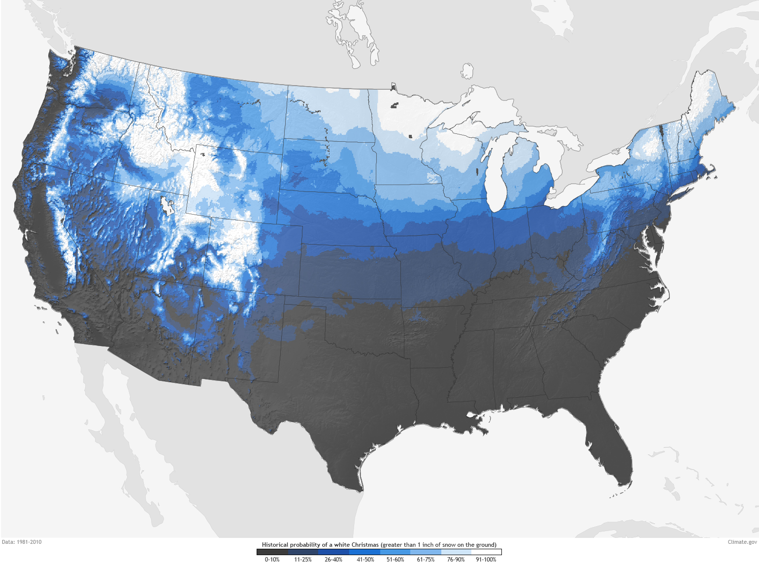 |
| Odds of a white Christmas. |
So enough about climatology, what about this years weather? There are actually some good indications that we could see a moderate to major winter storm on Christmas Eve. Well, why is that? It looks like we will see a very good setup where the moisture from early next week sticks around and is intercepted by much cooler arriving from the northwest.
 |
| 500 mb pattern showing northwest flow from BC and Gulf of Alaska |
Notice the kink in the flow setting up near the Washington/Oregon border. Where this sets up gives us a clue for where we can expect the heaviest snow.While there are model uncertainties as to where this kink sets up most of the model solutions are showing this. Here's a look at several solutions for Christmas Eve. Notice they are all showing a band of moderate to heavy precipitation (purple and red shading), they differ significantly on where to place the band.
 |
| Various model solutions for precipitation on Christmas Eve |
As this forecast period nears, we should be getting a better handle on where the band of precipitation sets up. The good news is whatever falls should easily fall as snow as we rid ourselves of the above freezing temperatures. So if you are wishing for a White Christmas this year, your wishes just might come true!
Thanks for the time that you put into writing this. Love your posts as always!
ReplyDelete