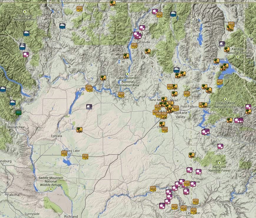
Two years earlier, 20 July 2012, a very similar weather event occurred in the Inland Northwest. Folks in Ferry county will remember it for the massive blow-down of trees and power lines that crippled much of that county for weeks. And people north of Lewiston will remember the baseball-sized hail that fell from a thunderstorm. But for the major population centers (Spokane/Coeur d'Alene, Lewiston, Wenatchee), this event wasn't very impressive.
But the recent July 23rd event brought a direct hit to parts of the Spokane metro area as well as locations to the north. As such, it has received a great deal more attention.
Before we get to the thunderstorm that hit the metro area, there were some other big storms that were also impressive. The first developed in southeast Washington near Pomeroy. It moved to the northeast, dropping hail the size of golf balls. Here's the radar image of it as it was crossing the Snake River.
 |
| Radar image of a severe thunderstorm at 3pm 23 Jul 2014. The yellow box is the NWS Severe thunderstorm warning area |
By the time the storm reached Pullman, the hail was still ping pong ball sized. Meanwhile, another thunderstorm was developing to the south that also prompted a warning. You can see both storms in the image below. The first storm is just north of Pullman, while the second storm is to the south of it.
 |
| Radar image of two severe thunderstorms at 335pm. |
This storm weakened a bit before reaching the Pullman/Moscow area. Hail was a bit smaller, the size of half-dollars.
As this was going on, another strong thunderstorm developed near Kettle Falls. It wound up producing the largest hail of the day. Two inch hail stones left dents in cars and cracked windshields along Highway 395 just south of Kettle Falls.
 |
| Radar image of severe thunderstorm near Kettle Falls at 327pm. |
These storms were all similar: high reflectivity cores indicating large hail and heavy rain, along with some strong winds. Below is the radar showing a different storm about to hit Spokane.
 |
| Radar image at 4pm of the storm that hit Spokane (left side of the image). |
Doesn't look all that impressive, does it? The storm over Benewah county (right side of the image) is the storm that previously went through Pullman, and is still putting down large hail. The storm on the left that's about to hit Spokane pales in comparison. Or does it? Here's the radar velocity image at the same time.
 |
| Radar Velocity image at 4pm |
Do you see that area of bright green colors? That is showing very strong winds (about 60 mph) heading for the west plains of Spokane. The NWS office measured a gust of 61 mph while the airport recorded a 67 mph gust.
Here's a video of the wind and rain at the NWS office.
As the gust front went by the radar, the color switches from green (which indicates winds blowing toward the radar) to red (winds blowing away from the radar).
 |
| Radar Velocity image at 420pm |
The light orange color in the center of the image indicates winds of 70 mph. On Five Mile Prairie, a wind sensor measured a gust to 65 mph. The storm continued to track to the northeast.
 |
| Radar Velocity image at 434pm |
By this time, the strong winds had reached the Deer Park and Chattaroy area. As you can see from these three images, the strongest winds followed a line from the West Plains, across northwest Spokane and Nine Mile Falls, and up to Deer Park.
Strong winds also hit the Idaho Panhandle, from Silverwood up to the Lake Pend Oreille area. The number of injuries sustained from falling trees was far more than we typically see in an Inland Northwest thunderstorm event. A map of the hail and wind reports is shown below. Or you can go to this site for a detailed look at the reports.
 |
| Severe Weather Reports for 23 July 2014 |
No comments:
Post a Comment