The computers all agree on a Friday afternoon arrival for the storm. The timing of the arrival will be crucial to the type of precipitation on Friday. Temperatures Thursday night will likely cool to freezing or below. But more importantly, temperatures aloft will also be cooling. If the storm arrives late in the day, temperatures will likely warm into the upper 30s or lower 40s, and the precipitation will fall in the form of rain. But if the storm starts by mid/late morning, our temperatures will likely be cold enough to keep the precipitation as snow. A few hours either way will make all the difference. At this point, we're betting on a cold rain or wet non-accumulating snow, but stay tuned for changes to the forecast.
As the storm continues to move down from the north, it will drag colder air into our region. Any rain will change to snow on Friday night and Saturday, except for possibly the lower elevations of the Columbia Basin, which might still be too warm for snow. One model wants to put a decent amount of snow in the Basin, while another model suggests that it will be in the Panhandle. These kind of small-scale features are nearly impossible to predict with any accuracy this far out. So at this point, the best we can say is low-land snow is possible on Saturday. For the mountains above the 4000' elevation, a foot of snow from this storm still looks like a good bet .
The second half of the story will be the cold temperatures. Highs for Sunday will likely be below freezing in most locations in the north. There's a good chance that we'll be revising these forecast temperatures downward as we get closer to the event.

Sunday night's temperatures will be coldest of the season so far. A lot will depend on whether there's snow on the ground. At this point this is our forecast for Monday morning's low temperatures:

So in summary, some timing/details of this weekend's weather are starting to come into focus. But this isn't a slam-dunk snow forecast for the low-lands. Confidence is much higher on the switch to colder weather.
Extended Forecast Models
For those who don't know, forecasters look at several computer forecasts. These are run by various nations, typically run 2 to 4 times each day, and they provide a forecast up to 10 to 15 days in the future. The U.S. National Weather Service runs the GFS model, the Canadians run the GEM model, the British run the UKMET model, and the European Weather Center runs the ECMWF model. Forecasters look at these models in hopes of seeing some consensus. If all of the models are forecasting similar weather, the forecaster has more confidence in the upcoming weather. Conversely, if the models are giving different forecasts (e.g. one says dry, another says snow, and yet another says rain), confidence is lowered. Yes, even if they agree, they could all be wrong. But typically, agreement equals accuracy.
Last Sunday, the models were all in surprisingly good agreement, especially for a drastic change in the weather. But then the computer forecasts produced on Sunday night and Monday showed less agreement. The GFS went back to the earlier idea of keeping the bulk of the storm to our east. The first image below is the GFS forecast made on Sunday for this coming Saturday (which was in our previous blog).
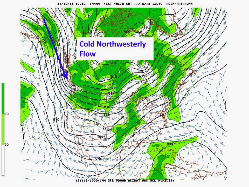
Compare the above image to the one below, which was made on Monday afternoon.

Overall, the pattern of the two forecasts is similar. The difference is subtle, but the second image shows more of the storm (look at the green shading, which represents moisture) to the east, over Montana and North Dakota.
Meanwhile, the ECMWF and GEM forecasts stuck to their guns, suggesting the storm would indeed arrive in the Inland Northwest. They modified their forecast a bit in the timing, starting things on Friday instead of Friday night.
The Tuesday GFS is now back in line with the other models. Why the change? We actually see this all the time. Looking 5 to 7 days out in the future, the computers often adjust their forecasts before locking on to an agreed upon solution. This situation is no different.
We do know that one thing that gives the models problems is extra-tropical transition of tropical cyclones. "What in the heck is that?" you ask. When a hurricane or typhoon (both of which are typical cyclones) move to the north, they transition into what we call extra-tropical storms. They take on characteristics like typical mid-latitude storms. When this happens, the computer models are often a bit shaky on their accuracy until the transition is complete.
Super Typhoon Haiyan, which hit the Philippine Islands last week, underwent such a transition in the past few days. Below is a YouTube loop of the satellite imagery from last Thursday until today. You can clearly see Haiyan move across the Philippines (left side of image) and into the South China Sea. Then Haiyan turned north, made landfall in southern China, and dissipated. But you can see the remnants of Haiyan turn to the right and move back out into the Pacific.
It's impossible to say whether Haiyan's extra-tropical transition had an effect on the GFS forecast for this upcoming weekend. But it is possible and does serve as a reminder of the atmospheric connection between storms.
No comments:
Post a Comment