Thursday, September 10, 2015

What will El Nino bring this winter?

After such a dismal snow year last year, many of you may be asking what kind of winter we will have this year.  Many may have already heard that a strong El Nino is present.  El Nino often brings warmer temperatures, so does this mean another bad year for snow?  In this blog we'll try and answer this question.

First of all, what patterns tend to set up during El Nino Winters?  Here is a graphic from the Climate Prediction Center...

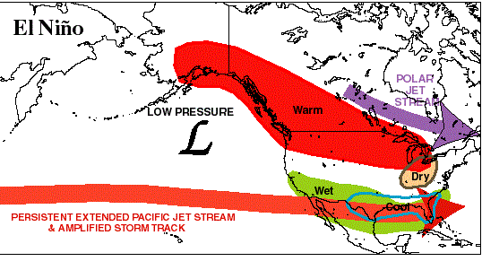
Idealized weather pattern during an El Nino winter.  During El Nino winters, a strong and persistent Jet Stream over the Pacific is oriented over the southern tier of states.  Cold air intrusions from Canada into the northern states are infrequent.

Typically during El Nino winters, the jet streams splits with the cold northern branch over southeast Canada while the wet Pacific Jet Stream sends weather systems to our south across California.  This tends to give us warmer winters, while precipitation tends to be more variable with some years a bit wetter than normal while other years a bit drier.

What is the official forecast from the Climate Prediction Center calling for?  The graphics below issued August 20th shows highly increased odds for a warmer-than-normal winter, with slightly elevated chances for drier-than-normal conditions.


To evaluate the current state of El Nino, we need to look at the equatorial region out in the Central and Eastern Pacific.  Here is map showing the current SST (Sea Surface Temperature) anomalies over the past month through September 5th.

Sea Surface Temperature (SST) anomalies in the Pacific for 9 Aug - 5 Sep 2015.  Red shading indicates warmer-than-normal while blue shading shows lower-than-normal SST's.

The important area to key on is along the equatorial region in the Central and Eastern Pacific (middle part of graphic).  Values warmer than 1.5C are an indicator of Strong El Nino conditions.  Currently there are values greater than 2.0C, which supports a strong El Nino.

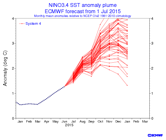
So how does this compare to past events?  Let's take a look.

Three-month average sea surface temperatures in the Nino 3.4 region of the equatorial Pacific for 2015 and the past 6 strong El Nino winters.
  
The purple line on this map is this year's current and projected trace.  While some uncertainty still remains regarding the peak of this event, it should end up as one of, if not the strongest El Nino, most similar to the strength of the 1997-1998 Strong El Nino.

So what has happened in past winters during Strong El Nino episodes?  There have been six cases since 1950.  First let's look at temperature composites for December, January, and February for past strong El Nino years.


As you can see, for the Inland NW, three of the six were much warmer than normal (1957-58, 1982-83 and 1991-1992) and two were near to slightly above normal (1965-66, 1997-98).  The 1972-73 Strong El Nino was actually cooler than normal.

What about precipitation?  Let's take a look...


In this graphic the yellow and orange shaded areas indicate drier than normal while the greens and blues indicate wetter than normal.  There's even more variability than with temperatures.  Two of the strong El Nino winters were wet (1957-58 and 1982-83), two were dry (1965-66 and 1991-92), and two were near normal (1972-73 and 1997-98).

So what do we gather from all of this?  The most important point is that every El Nino year is different.  Some of the differences are related to the timing of when the typical El Nino pattern develops.  During the 1972-73 event it wasn't until mid-February before an El Nino-like pattern kicked in.  Other years El Nino conditions start by January.  The main message here is that El Nino conditions are most favored during the second half of winter.  Thus, parts of November and December are at times more prone to fall and winter storms over the region.

Strong El Nino years also differ in terms of snowfall depending on where you live.  Below are images for snowfall for past episodes with the value on the far right the current 1981-2010 normals.


As you can see, for Spokane, every strong El Nino has brought at or below normal snowfall, with three of the six having less than 20 inches.  Meanwhile for Wenatchee amounts have varied greatly with each year different.  For Republic each strong El Nino year has brought close to normal snowfall, except for a snowy 1965-1966 year.  Bonners Ferry was also very snowy during the 1965-1966 El Nino, with at or below normal snow the other years.


The strong El Nino of 1991-92 saw an early season cold snap in late October. During the 1965-66 El Nino, most areas received near to above normal snowfall.  In 1972-73, a prolonged cold snap occurred in December with high temperatures several days in the teens and lows as cold as -11F in Spokane.  This was followed by another cold snap in January that lasted a week.  Take a look at the Spokane graphic below.

Spokane temperatures in the 1972-73 winter.  Blue bars show daily observed temperatures.  Brown shading shows the normal temperature range.  Red shading indicated above-normal temperatures.  Blue shading shows below normal temperatures.


The strong El Nino of 1997-1998 saw a brief cold snap with highs in the lower teens in January.

Meanwhile the El Nino of 1957-1958 saw no such cold snaps.  Here is the Spokane trace for that winter.

Spokane temperatures in the 1957-58 winter.


So while El Nino years tend to be warmer, most have at least brief periods of very cold or snowy conditions.

For this upcoming year are there any indications of what type of El Nino year we will have?  First, persistent high pressure has been evident in the Eastern Pacific Ocean off the Washington, Oregon, and British Columbia coast.  Note the large positive anomalies (yellow, orange, red colors) in the graphic below.

500mb Height anomalies for April 1 - August 31, 2015.  Red shading indicates higher-than-normal pressure while blue shading shows lower-than-normal pressure.


The longer this persists, the more likely we will prone to early season fall and winter storms as high pressure in the Eastern Pacific results in north-northwesterly flow over the area bringing cooler and potentially wet storms into the area.  However with the current strong El Nino the tendency for upper ridging may not last long.

To summarize, despite the current strong El Nino, be prepared for winter like conditions especially for the early part of the winter.  As winter continues on, El Nino like conditions becomes increasingly favored.  Thus after this winter is over, most will look back and probably think of this being a mild winter.

What does this mean for our mountain snow pack?  We'll address this in another blog in the near future.

.

Monday, August 31, 2015

Does this mean summer is over?

Our hot summer came to a screeching halt on Sunday with a Pacific cold front bringing our first widespread rain in what seems like months.  The forecast for this week is decidedly cool, with daytime highs in the 70s and lower 80s.  And one look at the calendar begs the question:  Did summer just end without any warning?  Kinda felt like autumn on Sunday didn't it?  And we often say that on average, summer in the Inland Northwest is between Independence Day and Labor Day.

It's hard to define when one season ends and another begins.  But of all 4 seasonal transitions, the summer-to-fall transition is typically the most marked.  A marked transition doesn't happen every year.  Some are more noticeable than others.  The most impressive "autumn arrival" was probably 1959.  Here's a plot of the temperatures for that summer and fall in Spokane:


On September 12, the mercury reached 90F in Spokane.  A cold front moved in, dropping the temperature to 83F on the 13th, 65F on the 14th, and only 51F on the 15th.  But what's most impressive is that after that, the temperature never warmed above 67F for the rest of the autumn.  In other words, Spokane said good bye to the 90s, 80s, and 70s all with one cold front.

At this point we're not expecting a dramatic repeat of that event for 2015.  Spokane averages one day in the 90s in September and 7 days in the 80s.  The record is 10 days in the 90s, back in 1938.  And no, Spokane has never hit 100F in September.

Looking at the warmest 8 summers (based on June, July, and August average temperatures), only one (1958) had a normal September.  The other 7 were all much warmer than normal in September.  

Year Jun Jul Aug Sep
1922 +7.6 +3.2 +2.2 +3.1
1938 +4.5 +5.0 -0.9 +8.2
1940 +6.0 +2.8 +1.9 +5.1
1958 +3.3 +3.0 +4.9 -0.9
1967 +1.2 +0.6 +5.7 +5.7
1998 +0.2 +5.3 +3.0 +5.5
2013 -0.6 +3.9 +3.5 +3.4
2014 -0.6 +5.7 +3.5 +3.5
2015 +9.1 +4.2 +4.2 ???

The folks at the Climate Prediction Center are also favoring a warm and dry September.  Here's the outlook they produced today:


It calls for below-normal precipitation with above-normal temperatures for the month of September.

We typically look at a model called the GFS for forecasts of the weather for the next 7-14 days.  But when we want to look farther into the future, we look at the CFS (Climate Forecast System).  So let's see what it says for September.  First, we'll look at the CFS that was run back on August 10th.

The yellow and orange colors indicate areas where the model thinks temperatures will be above normal in September.  Large area of abnormal warmth over Alaska and Canada, spreading into most of the western US.

Now let's see the CFS from August 20th:


Notice the change.  The model still expects warmth in the West, just not nearly as strong or widespread.

Now here's the latest run of the model, which was fed the data from August 20-30:

We're back to a large area of abnormal warmth over Alaska and Canada, but only a minor area in the northern Rockies.  

The folks at CPC look at this (and a lot of other data) and concluded a warm September for the West.  So don't put away your summer clothes just yet.


Thursday, August 27, 2015

Strong Cold Front on Saturday

You've probably already heard about the change in the weather for this weekend.  Yet another strong summer front will be moving through the Pacific NW.  And yes, it will bring the potential for rain to the area.  Unfortunately, it doesn't look like much for our side of the Cascades.  Let's take a look at 4 models forecast of 24 hour rainfall for Saturday and Saturday night.  First, here's the GFS

GFS forecast of 24 hour precipitation ending 5am Sunday 30 Aug

The GFS shows the majority of the rain falling over western WA and into BC.  This would bring rain to the Cascade fires, but not as much to the rest of the fires in the Inland Northwest.  Here's the NAM forecast:

NAM forecast of 24 hour precipitation ending 5am Sunday 30 Aug
The NAM paints a similar picture.  But you'll notice more rain that is forecast east of the Cascades near Omak.  This would obviously be great new for the Okanogan Complex and North Star fire.  It's also a bit wetter in the Idaho Panhandle, which would be equally good news.  Now let's look at the Canadian forecast:
GEM forecast of 24 hour precipitation ending 5am Sunday 30 Aug

The Canadian GEM model has been consistently the driest for the Inland NW. This would bring less than 0.10" of rain to the fires.  And one last model to look at:
Forecast of 24 hour precipitation ending 5am Sunday 30 Aug

Similar to the other models.  Heavy rain in western Washington and the Cascades, much less in eastern Washington.

But the bigger story will be the wind.  This storm will be similar to the system we had 2 weeks ago on August 14th.  Here's the current wind forecast:

These are sustained winds, and will be 30-40 mph in much of the Basin, Palouse, and Spokane area.  And here's the forecast wind gust:

Wind gusts of 45 to 55 mph.  This is a strong front.  The winds might actually subside a bit in the afternoon after the front moves through the area.

These kind of winds will cause more blowing dust, similar to August 14th.  Here's what the satellite looked like on that day:

MODIS satellite image showing wild fire smoke and blowing dust on 14 August
The blowing dust in the light brown streaks in the middle of the image.  This event closed down Interstate 90 and Highway 395.  Here's some images from the metroforensics blog:


The wind may also cause problems with the numerous wild fires in our area.  Here's a map showing the active fires that are currently burning.  


Wildfires in the Inland NW 27 August

The cold front will move through the region in the morning with very strong winds.  These winds could cause wild fires to spread quickly.  Eventually the atmosphere will become moister as the temperature falls and moisture arrives.  This could help the fire situation.  The window between the frontal passage and the moisture arrival will hopefully be short, keeping fire danger to a minimum.  But if there are several hours in that window, some of the fires could make significant runs to the north and east.

Monday, August 10, 2015

Potential for Severe Weather this week

As we talked about in our previous blog, the weather pattern is setting up for a potential severe weather event on Thursday, August 13th.  Before we get there, there is a potential for thunderstorms today through Wednesday.  Here's the current weather pattern:

GFS 500mb heights, winds, and Humidity (green shading) valid 11am PDT Monday 10 Aug


The low off the Washington coast will slowly creep south along the coast over the next couple of days.  Remember, winds go counter-clockwise around low pressure in the Northern Hemisphere.  That means to the east of the low, the wind blows from south to north.  This "southerly" wind will bring moisture up from the sub-tropics.  We've already seen our dew points rise over the past couple of days.  

Dew point at Spokane August 9 and 10

Note that the dew point has climbed from the mid 30s two days ago to around 50.  That trend will continue for the next few days. So we will have moisture.  The hot temperatures will provide the instability. That combination will produce thunderstorms.    Here's a forecast of radar reflectivity from the HRRR model valid later this afternoon:


The HRRR expects thunderstorms from northeast Oregon and central Idaho to move into the Inland Northwest.  Some of these could produce gusty winds and blowing dust.

While these storms could be strong, they are lacking one of the ingredients for a "big" event:  lift.  The low offshore is too far away to contribute much lift.  And as it continues to drift south, it will be even farther away from us.  So the storms for the next three days will have to rely on moisture and instability alone.

But on Thursday, that all changes.  The low will begin to "eject" to the northeast.  This is a common pattern.  The tough part of the forecast is the exact track and timing of the low.  Here's the current forecast from the GFS model:


Yes, it looks nearly identical to today.  The difference is that at this point the low moving to the northeast.  This is a classic pattern for severe weather in the Inland Northwest, and it's similar to some of the bigger events we had in 2014.  That's not to say we're going to see a repeat of a 2014 event.  But the potential is there for strong and widespread storms.  Here's the NAM and GFS model forecasts of precipitation for the 5pm-11pm time frame Thursday evening.


NAM (upper) and GFS (lower) forecast of 500mb heights (thin lines) and precipitation (green shading) for 5-11pm PDT Thursday evening.


First, you can see a difference in the predicted location of the low.  The NAM has it over southwest Washington, while the GFS is slower with the low offshore still.  But both models show convective precipitation over much of eastern Washington and the Idaho Panhandle.    But the ECMWF (not shown) is even farther south with the position of the low, and so it has even less convection. 

Here's the forecast CAPE (atmospheric instability) from the NAM and GFS:
NAM Forecast CAPE Thursday 2pm

GFS Forecast CAPE Thursday 5pm


Both models show plenty of instability, around 1500 J/kg, which is plenty for strong thunderstorms here.  As you can see, the best instability looks like it will be over the northern and eastern mountains.  Details like this could easily change over the next couple of days so stay tuned as we get a better idea of how this event will pan out.  If the ECMWF is right, it could be a non-event, as the low would cross over us at night.  


Saturday, August 8, 2015

Roller Coaster Weather

You've probably heard the old adage "If you don't like the weather, just wait a little while and it will change."  While that saying is undoubtedly over-used, this week it will be true.  The cause of this roller-coaster weather will be a large low pressure system that's currently off the BC coast.  Here's the 500mb pressure map Saturday morning:


You can see the low just west of British Columbia.  During the first half of this week, the low will very slowly move down the coast, reaching Northern California by Wednesday:


This will do a couple of things.  First, it allows the very hot ridge of high pressure that's currently over Texas to amplify over the center of the U.S.  The Inland Northwest will be on the western edge of this ridge, but still close enough to feel its effects.  Our temperatures are going to jump up in a major way, and quickly.  After are mild weekend, temperatures will warm about 8 degrees on Monday, and then another 5 on Tuesday and Wednesday.  The result is a very hot middle of the week.  Here's the current forecast:


The other thing this pattern will bring is thunderstorms.  The area between the off-shore low and the mid-US high will see persistent flow from the south.  This brings moisture with it, which will bring the potential for thunderstorms.  Initially, these will be rather isolated and won't have much rain with them.  Any lightning from them will have the potential to start new wildfires.  

By Thursday, the low will stop moving south and begin to "eject" back into the jet stream to our north.  As it does so, it will track directly over the Pacific NW.  Here's the forecast for Thursday afternoon:


This scenario is nearly a "classic" pattern for strong thunderstorms in our area.  The ingredients we look for are: 

  • Instability: The 3-day hot spell will do a good job of destabilizing the atmosphere.
  • Moisture: The southerly flow will bring up moisture from the south.
  • Lift: The strong low will supply the lift as it moves over our area.
The exact details are still too far out to get into.  So as we get closer to the potential event, we'll likely update this blog.  Suffice to say, if everything comes together just right, we could be looking at a significant thunderstorm event on Thursday afternoon/evening.

In its wake, the low will bring much cooler temperatures.  Here's the forecast high temperatures for Friday:


So, enjoy the roller-coaster ride this week.

Wednesday, July 15, 2015

Will this be the hottest summer ever?

As we wrote in our previous blog, June 2015 was the hottest ever for our area.  But not just in the Inland Northwest.  Here's an image showing the extent of the record heat.


All of the areas in dark red had their hottest June on record.  And for precipitation, this was one of the driest:


This past June wasn't just a little warmer than normal, it was crazy hot.  It was actually hotter than most Julys or Augusts.  The 105F at Spokane Airport wasn't just the hottest June day ever, it was the 5th hottest day in Spokane history (click here to see a discussion of the hottest day ever in the Inland Northwest).  It's interesting to note that Europe was also extremely hot.

  • Germany set it's all-time hottest temperature ever this year on July 5th with a temperature of 104.5F.  
  • Paris had it's second hottest day ever on July 1st with a reading of 102.2F.
  • Geneva hit 103.5F, an all-time record for that city.

The two most frequent questions that we're hearing are: 1) will this be the hottest summer ever? 2) what caused the record June heat?

In order to answer question #1, it's always best to look back at history.  While we've never seen a June as hot as this, there have been some historical hot Junes.  So what happened for the rest of the summer in those years?  Below is a table showing the 10 warmest Junes and the average temperature anomaly for those years.

Average Temperature Anomalies for the 10 warmest Junes
Year
Jan
Feb
Mar
Apr
May
Jun
Jul
Aug
Sep
2015
+3.8
+7.3
+6.0
+0.1
+5.2
+9.1
?
?
?
1922
-6.7
-5.8
-2.6
-2.8
+0.9
+7.6
+3.2
+2.2
+3.1
1940
+2.8
+4.0
+5.8
+3.2
+5.0
+6.0
+2.8
+1.9
+5.1
1918
+4.4
-0.3
+3.5
+2.4
-2.0
+5.9
+1.7
-2.8
+5.2
1992
+4.5
+7.0
+6.0
+1.4
+3.3
+5.7
-2.3
+0.8
-2.3
1938
+4.3
+1.7
+1.6
+2.4
+1.4
+4.5
+5.0
-0.9
+8.2
1903
+4.9
-4.2
-0.5
-2.6
-1.3
+4.3
-4.5
-1.4
-4.1
1961
+3.1
+5.1
+0.4
-2.3
-2.5
+4.3
+1.9
+5.3
-3.7
1982
-1.0
+0.2
+0.7
-3.9
-1.3
+4.2
-2.5
+1.1
-0.2
1932
-1.1
-2.2
-1.2
+2.6
+0.2
+4.1
-0.9
+0.9
+1.7

This year has been at or warmer than normal for each month.  Some of the past hot Junes seem to have "come out of nowhere", such as 1922 where the winter and spring months leading up to June were colder than normal.  While 1940 was just plain warm, with every month above normal.  Some years are similar to 2015 (1992, 1938) in that they had mild winters/springs with a hot June.  But in those years, the remaining months of July-September were not consistently hot.

Overall, the historical numbers show us that while the July-September period following a hot June are often warm as well, it's far from a slam dunk.

July is almost half-way over and while temperatures have recently cooled, we're still running several degrees above normal. The NOAA Climate Forecast System continues to predict a warmer than normal Aug-Oct period.  So the odds are good that we'll above-normal temperatures for the next few months and possibly longer (see below).

This leads to the second question:  What caused this hot spell?  The answer to this is much more vague, but it's possibly related to El Nino.  The equatorial water of the Pacific (where El Nino is monitored) has been showing a steady warming for the past 9 months.

Equatorial Pacific Sea Surface Temperature amonalies

The Nino 3.4 region (second graph from the top) shows that El Nino conditions were barely met (i.e. greater than 0.5C anomaly) through much of this past winter.  And most climate folks agree that the weather patterns we saw this past winter were not typical of El Nino (remember all the snow and cold in the Northeast?).  In a typical El Nino event, the signal will begin in late summer, reach a peak in mid-winter, and then fade during the spring.  But this year, the warming strengthened during the spring and summer months. 

Typically, the presence of El Nino has little effect on summer weather in North America.  But the weather patterns this year of late spring and early summer resembled those of El Nino.  And the 3-month precipitation anomaly for this year looked El Nino-like, with wet weather in the southern states (remember all the Texas flooding in May) and dry weather in the Pacific NW.


So was El Nino partly to blame for our hot June?  It's impossible to say with any certainty.  Our last warm June (1992) had a moderate-strength El Nino in the preceding winter that was fading out by June.  And the super El Nino in the winter of 1982/83 had a warm June in 1982.

Some of you may be hearing projections of a "strongest El Nino ever" for this upcoming winter.  Is there any truth to these, or are they just media-hype?  Here's the El Nino prediction from the NOAA CFS model:

The solid black line is the Nino 3.4 temperature anomaly back to 2014, showing the gradual warming.  All the thin red and blue lines are forecasts, and the black dashed line is an average of the forecasts.  As you can see, the average forecast peaks at just over 3.0C around November.

Below is a similar forecast from the ECMWF:


This graph doesn't show the average of all the red forecasts, but you can see that it would be somewhere around +3.0C, peaking in November/December as well.

The official definition of a "strong" El Nino is a 3-month average anomaly greater than 1.5C for 5 months.  These forecasts certainly suggest a strong El Nino for this winter.  And to put it into historical context, there are only 2 winters with El Ninos as strong as the one currently forecast:  1982/83 and 1997/98.  Both of these winters had a strong impact on the winter weather in North America.  We'll be writing more about El Nino in the coming months as the details become clearer.