Has it seemed dry to you this Spring? If you said yes, you are correct! In this blog we talk about the dry conditions, which have been record dry in some areas, and what this may mean heading into summer.
First let's look at March and April % of normal precipitation, courtesy of WestWide Drought Tracker
 |
| % of normal precipitation March-April 2021 |
The entire region has been drier than normal, especially in the Columbia Basin (5-25% of normal). In fact, many areas finished in the top 5 for driest March-April periods with some records noted below.
And if we go back to February, record dryness is noted for portions of the Upper Columbia Basin into the Spokane area.
 |
| Percentile ranking for precipitation February-April 2021 |
While it has been record dry in some areas in the past 2-3 months, are we in a drought? To help answer that question we need to understand the big picture.
One way is to look at precipitation anomalies over a longer period of time. Meteorologists often like to look at what has happened beginning October 1st. This is when fall storms begin to invade the region. Below is the % of normal precipitation since October 1st, also referred to as the beginning of the "Water Year" (courtesy of High Plains Climate Center).
Again, the Columbia Basin sticks out as the driest region, along with drier than normal conditions over NE Washington and North Idaho. The Cascades, Okanogan Valley, and Okanogan Highlands are in better shape.
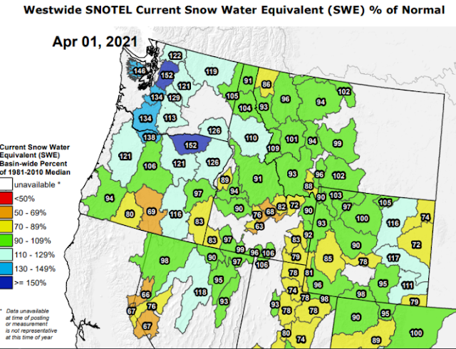
Another factor is mountain snow pack. Snow that accumulates over the mountains during the fall and winter melts in the spring and feeds many area rivers and streams, providing water supply into the summer. Typically snow pack peaks around April 1st, with the graphic below showing near to above normal snow pack.
The snow has been coming off the mountains a little quicker than normal over Eastern WA and North Idaho as noted by the latest mountain snow pack % of normal as of May 8th.
Taking into account the recent dry conditions and the mountain snow pack, the
Climate Toolbox has several useful ways for plotting data including soil moisture.
As the map shows, much of the Wenatchee area, Columbia Basin, Palouse, LC Valley, and portions of North Idaho are about as dry as it can get for this time of year ranking in the bottom 2% of terms of soil moisture. The snow pack is helping out the mountains especially the Cascades.
 |
| US Drought Monitor as of May 6th, 2021 for Washington and North Idaho |
Moderate (D1) drought is depicted over much of Eastern Washington and North Idaho with D2 (Severe) drought over much of the Columbia Basin. Yellow shading (D0) isn't drought but rather abnormally dry conditions.
What does the long term precipitation outlook offer? The Climate Prediction Center is calling for elevated odds of drier than normal conditions over the region.
 |
| CPC precipitation outlook for May-July 2021 issued April 15th, 2021 |
This does not look good! Elevated odds of drier than normal conditions may result in a continued expansion and severity of the drought. The good news is that the mountain snow pack should allow for adequate water supply this summer over much of Central Washington. Eastern Washington and North Idaho water supply isn't looking as good. The link to the latest forecast issued by the NW River Forecast Center can be found
here |
| NWRFC Water Supply Forecast valid April-September 2021 |
Lastly, what does this mean for fire season? Often the severity of fire season around this area is related to number of critical weather events that set up each summer, such as the Labor Day wind storm last year. Amount of lightning can also play a role depending on how dry the landscape is when lightning occurs. While these specifics can be tough to predict months out, the recent dryness is a concern for grass fire potential across the Columbia Basin and portions of Eastern Washington heading into June.
The latest fire outlooks from NIFC (National Interagency Fire Center) can be found
here. These are updated on the 1st of each month.


