FALL/WINTER RECAP
So far this water year (Precipitation totals beginning October 1st) has been off to a very wet start. Here is a map for the entire west showing how wet it has been.
As you can see, for many places across eastern Washington and north Idaho precipitation since Oct 1st ranked in the top 10%. For much of northern California into western Wyoming the October-February period ranked the wettest on record.
Wettest Period on Record for Spokane
If you look closely at the map above, you can see a small area of dark green (record wet) over Spokane. Sure enough, the October-February period was the wettest on record for Spokane. The month of October contributed an all-time monthly precipitation record 6.23 inches to the 16.28 inch total. Here is a graphic (October 1st through March 7th) of how Spokane ranked.
Not only has it been wet, it's been a rather cold winter as the map below shows.
No records for cold temperatures, but certainly below normal especially in the Columbia Basin.
A LOOK AHEAD
The weather pattern is about to change. The Inland NW is heading into a milder pattern through next week and there is a lot to talk about. Let's begin with tomorrow (Thursday).
 |
| 12z/8th GFS forecast of 500mb heights and 700-500mb Relative Humidity for 4 PM PST Thursday (00z Friday) |
A milder southwest flow pattern develops with increased moisture (green shade) entering the region. This will bring a shot of rain except snow for the Cascades, northern Washington and Idaho mountains, and some northern valley areas. Most of this will fall in the afternoon and evening. After this, a low pressure system tracks along the Canadian border on Friday producing windy conditions for much of the area.
 |
| NWS Forecast of wind gust issued Wednesday afternoon for Friday afternoon (10 AM-4 PM PST) |
After that, the milder pattern continues...here is Saturday
 |
| 12z/8th GFS forecast of 500mb heights and wind 10 AM PST Saturday, March 11th (18z Saturday) |
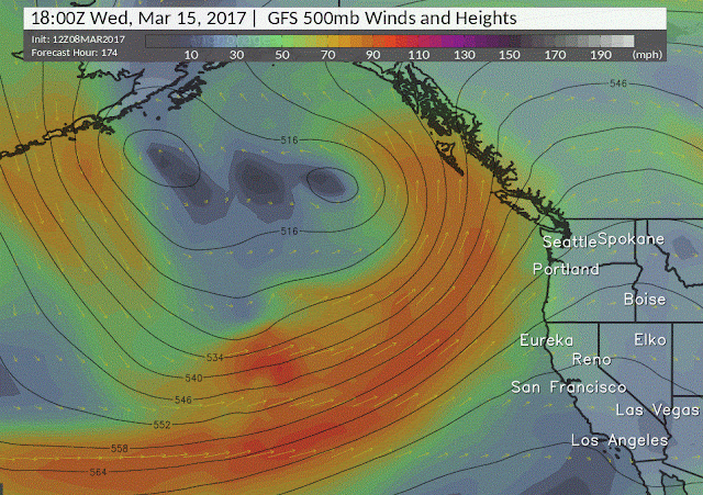
And how about next Wednesday (March 15th)
The mild weather pattern continues as southwest flow continues. Overall all of the computer models are in good agreement of this mild pattern continuing through at least the middle of next week.
Here are what some of the computer models are suggesting for Spokane for temperatures:
 |
| Meteogram for Spokane Airport showing model forecast of temperatures beginning today (Wed) going out through next Wednesday from left to right |
High temperatures warming into the lower to mid 50s are a good bet early next week.
The mild weather and occasional rain may cause some minor flooding concerns. The good news is that we don't see any prolonged periods of heavy rain. However the combination of rain and snow melt will lead to rises on area rivers and streams. So where is the snow now? Here is map showing how much water is in the snowpack.
 |
| Modeled SWE (Snow Water Equivalent) for 1 PM PST today (Wednesday, March 8th) |
Overall there is plenty of snowpack in the mountains...as well as quite a bit in the mountain valleys north and east of the Columbia Basin. Here's a map highlighting our current areas of concern for possible flooding for Thursday night and Friday.
For the latest river forecasts, please go to the following link
To summarize, after a cold and wet winter milder temperatures and occasional rain may lead to minor flooding. In addition windy conditions are expected for much of the area on Friday.


