In our last blog, we stated that things weren't looking real great for a White Christmas in the Inland Northwest this year. As expected, the weak system on Wednesday didn't amount to much for most locations. Is there any hope for the next system on Friday? Actually, yes! Let's look at the ingredients.
First, we need cold air. While Wednesday's wimpy system didn't bring much precipitation, it did bring in some good, cold air. While it didn't feel real cold this morning, we will be colder tonight. Here's our forecast low temperatures for Friday morning:
And we will stay cold on Friday. Here's the forecast high temperatures:
The next thing we need is moisture. As we said in our previous blog, storms coming at us from the northwest (what we call Northwest flow) typically don't have much moisture in them. This isn't a good weather flow pattern for our area. But this storm is one of those exceptions to the rule. The image below shows the moisture plume in the eastern Pacific. Without getting into a lot of detail (we'll save it for a future blog), the shading represents moisture, and the black arrows are wind direction. This image shows moisture coming up from near the Hawaiian Islands, over the ridge of high pressure, and pointing into the Pacific Northwest.
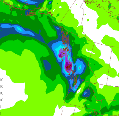
So this time we will have a good fetch of moisture to work with. The computer models are in decent agreement, which always helps our confidence in the forecast. We'll show the GFS model. Here's the precipitation forecast by 4am Friday:
You can see that while there's some lingering showers in the southern Panhandle, the main precipitation from Gulf of Alaska system will just be reaching the Cascades at this time. The snow will then spread across eastern Washington and north Idaho during the morning hours. So the Friday morning commute shouldn't be impacted for the most part. Here's the total precipitation forecast by the GFS by 10pm Friday evening:
You see plenty of precipitation over the Cascades, and then another blob over southeast Washington. This area (Pullman, Moscow, Lewiston, Grangeville) does well in these northwest flow events, and they will see the most snow from this event. Farther north (e.g. Spokane) will see lesser amounts, but still a good shot of precipitation. You can see that the GFS gives very little precipitation to central Washington, which is typical. This is the Cascade precipitation shadow.
All of this precipitation will fall in the form of snow. It should be a dry snow, and road surfaces will be cold, so we don't expect much ice on the roads; packed power should be the predominate road condition for your drive home on Friday afternoon. But it will probably be snowing fairly hard during the evening rush hour.
Here's an image showing how much snow we expect from this storm:
Our forecast calls for about 3" in Spokane, while Pullman/Moscow could see around 7". But just about everybody gets some snow. Wenatchee and Moses Lake should get less than an inch.
There are some models that are painting a slightly different picture. The WRF model run at the University of Washington is shown below:
This model still has the heaviest amounts of snow in the Cascades and southeast Washington area. But it has a band of heavier snow from Omak to Pullman. This model would give Grand Coulee about 7". While this isn't impossible, it's not considered very likely. We shall see. Note that there is also snow forecast for the Puget Sound area, especially north of Sea-Tac.
But then the question is: can we keep this snow for 4 more days in order to have a White Christmas? Obviously, the more snow we get on Friday, the better our chances will be to keep it. But will the weather cooperate?
The forecast does show warmer temperatures arriving for Sunday and Monday, but then cooling back down for Christmas Eve and Day. Spokane is forecast to reach the upper 30s, with many locations south of I-90 warming into the lower 40s on Monday.
We might also see a little rain on Monday. But it's not the rain and the warmth. You can have a day of 40 degrees and some rain and only lose an inch or so of snow. But we'll also have a warm, moist wind from the southwest on Monday. This kind of weather can eat snow in a hurry. If you have anything left by Tuesday morning, it should survive until Christmas.


.gif)


