Showing posts with label eastern Washington. Show all posts

Friday, November 4, 2022

Storm Part 2...Will your house have electricity in the morning plus a look beyond?

There's a good chance of seeing multiple power outages tonight with our upcoming wind storm.  And depending on how many outages there are, our much-appreciated hard working utility folks may not have all the power back on before you get up Saturday morning.  As such, you may want to make some contingency plans.  It would be a good idea to charge your battery powered devices this evening just to be safe. 

Round 1 of our storm series is over. The main result of it was heavy snow which fell over many parts of the Inland Northwest overnight and into this morning.  It is very unusual to have this much snow this early in the season, let alone for the first snow of the season. Here are the morning snow totals.  Since it snowed much of the morning, these totals will likely increase from what's posted here.


Now it's time to get ready for Round 2 and it could be a doozie: the wind storm.  The various computer models have their usual disagreements, but they're all saying it's going to be windy tonight.  One chart we often look at for wind events is the 850 mb wind forecast.  Think of this as the winds about 3000-5000 feet elevation.  Usually a wind of about 50 knots (58 mph) will get our attention.  In this instance, the GFS is forecasting 65 to 78 knots of wind tonight!  Other models so something of a similar magnitude.

850 mb winds for 11PM Friday

So the question is: can that wind that is 3000-5000 feet overhead mix down to the ground?  The answer is quite complicated and difficult to answer.  Meteorologists often struggle with this a lot.  In some instances, those strong winds above us stay above the ground and we never feel them.  But there are situations where those strong winds do make it to the surface.

One of those mechanisms is cold fronts.  And that's exactly what we'll have moving through our area tonight.  The front is moving west to east, and will go through Spokane around 1am tonight.  Before that, the rain in the Spokane area will taper off around 6pm, and then the winds will begin to crank up.  It will be windy with gusts up to 50 mph late this evening and then the front plows through. We still think there is a good chance that when the front goes through, we will see wind gusts in the 60-70 mph range for some locations.  The damaging winds should begin to taper off  before sunrise Saturday.

Here's the peak wind forecast.  Keep in mind that the valley locations like Colville and Republic may not see the highest wind speeds, but they have more trees to potentially knock down and thus produce more power outages. 


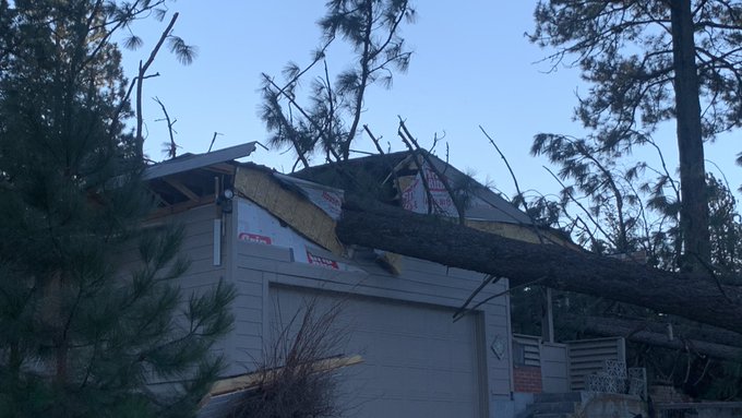
So what can we expect from an event like this?  At this point, there are some similarities between this event and the 13 Jan 2021 event.  That event had 850mb winds of 57 knots just before the cold front came through, which resulted in a gust to 71 mph at Spokane Airport.  But similar to tonight's event, the strong winds only lasted about 3 hours.  Still, the tree damage was significant, and power outages lasted for several days in some locations.


After the wind storm, we aren't done with the active weather, we still have Rounds 3 and 4 to contend with. 

Round 3 promises to deliver more snow, and in some cases it could be significantly more than what we just saw. The heaviest snow possibilities are honing in on north-central Washington.  The surface low will track south of us, which favors that part of the Inland NW due to easterly low-level winds pushing into the Cascades. This will cause rising air over much of that area, rather than the more typical downslope/rain shadow effect.  Snow should start there on Sunday morning.

Surface low position (off Vancouver Island at 11 am Sun) and precipitation

But since this low is tracking south of us, the front will move very slowly across the region.  It won't reach extreme eastern WA and the Panhandle until 24 hours later, Monday morning.

Surface low position and precipitation as of 11 am Monday

Here's the current forecast storm total snow for this event.  


And lastly, Round 4 will be the unusually cold temperatures that move into the region behind this storm.  There's a good chance that some locations will break daily records.  Here is a list of the record highs which could be broken (denoted in yellow):


As well as the record lows (denoted in yellow):


If there are widespread power outages from the wind or upcoming snow event, the cold temperatures next week could have a much bigger impact than they usually would. 


Monday, March 23, 2020

A worsening drought over parts of eastern Washington?

   Springtime across portions of the Inland Northwest has been very dry at least compared to climatology. We can measure just how dry using various tools in our meteorological tool box. One of the conventional tools we use is simply looking at precipitation maps across the region. So how have things looked over the past 90 days? 


As you can see things are highly variable across the region. near the Cascades it has actually been quite wet, with precipitation amounts nearly twice the average amount over the past 90 days. Also near the Washington/Idaho border amounts have been close to normal (aside from the southern Palouse, LC Valley, and Blue Mountains). However one area that  stands out is a portion of central Washington in the lee of the Cascades stretching from Omak down to Moses Lake and The Tri-Cities and Yakima areas. Some of these locations have seen only a quarter of the normal precipitation during this period. 

If we add the November precipitation amounts to the mix, the resulting map doesn't look much different for the dry areas. 

So that got us thinking is this a record of some sort? Now granted these statistics are rather arbitrary, After all, who calculates records from 11/23 through 3/21? Not many people, but just for fun we will examine some of these odd records. First we will look at Yakima. 

Yakima, WA precipitation 11/23-3/21
So in fact this is a top 10 driest period for Yakima, but it was actually drier in 2018. Now how about Omak? Not quite top 10 but close. 


And finally lets look at the Ephrata:

Only in 16th place out of the last 70 years and the driest since 2014. So although this is noteworthy, it isn't really a historic dry spell. 

But precipitation alone does not tell the entire story about a dry spell of weather. Other things to take into consideration during this period include; winds, temperatures, relative humidity levels, and solar radiation. All of these parameters will impact the amount of evaporation or evapotranspiration that can take place and how quickly the soils will dry out. That is a lot of information to keep track of, however fortunately we have a relatively new and very useful tool called the  Evaporative Demand Drought Index or EDDI. This takes all the aforementioned parameters into account and states how thirsty the atmosphere is. So what is this index showing for the area? If we go back to November things look particularly bad:
Over the entire Lower 48, no area has seen  more widespread and harsh drying conditions compared to normal. The categories on the map correspond to our typical drought outlooks. In this case the shading over eastern Washington corresponds to an ED4 or an exceptional drought. Does that mean this area is now in an exceptional drought? Not necessarily. A drought is not built on four months of weather alone, but if these trends continue we will certainly be faced with worsening drought conditions over this portion of eastern Washington. Since November here is how the drought monitor has been evolving across Washington.

These images start in the middle of November and advance two weeks at a time. The last image shows the drought conditions as of the middle of March.


Specifically looking at the March 17th the outlook:


This map shows that almost 23% of Washington is in a D1 or moderate drought which just so happens to correspond closely to the first precipitation maps we showed. But what is interesting is the EDDI maps show worse conditions than what's depicted by official drought maps and sometimes this can foretell the trends. EDDI itself is not a drought prediction, but at short timescales (such as what we have shown), it indicates the potential for drought (or trends). So this area certainly bears watching.


So looking past the EDDI values what do the longer range weather forecasts tell us? That is always a tough question to answer, but lets look. The 8-14 day outlook through the beginning of April calls for near normal precipitation and cooler than normal temperatures. Near normal precipitation amounts would certainly help. The cooler than normal readings should also temper the thirstiness of the atmosphere however that could be overcome by having unusually dry air masses in place or prolonged windy conditions.


As for the April outlook, things don't look terrific for a dramatic improvement at this point with below normal precipitation favored at this time with an equal chance of normal temperatures.


And finally, if we want to peer even farther into the future (April-June) the prognostication right now would suggest worsening drought conditions. But we will just have to wait and see.


So what are the ramifications of a drought over the Columbia Basin? While much of the area is irrigated for agriculture, there are areas which also have a considerable amount of sagebrush which could eventually lead to quick burning fires this spring. It could also lead to more blowing dust than normal on a windy day.  Part of this dry area also encompasses some denser fuels both east and west of Omak. Right now the nearest snotels (snow measuring sensors) depict a snowpack around 65%. It's too early to say if this will lead to a busier than normal fire season in these areas as we have found the leading cause of a big fire season is a hot and dry summer.

We will revisit this topic later this Spring to see how things panned out.


Saturday, January 14, 2017

A wintry mess before the very wet and milder arrives next week?

So as we mentioned in our previous blog post, we are expecting to finally break out of this latest cold and dry weather pattern by early next week. So what is going to be responsible for this change? Here is a look at the current weather maps which are supported by what we see on satellite (a good sign if we want to follow a particular weather model):

500 mb map (left) with Integrated Vapor Transport (shows atmospheric rivers denoted by bright colors). Water vapor satellite imagery  on right. 
The most noticeable things on the left chart are the large high pressure ridge centered over the Inland Northwest (Large H) as well as the atmospheric river developing north and west of Hawaii. Over the next several days we expect the presence of the high to persist over our area. This means more fog, low clouds, and very cold temperatures in the valleys with light winds. This is because high pressure systems in the winter typically lead to strong inversions (temperature increasing with height). This is especially true when there is widespread snow cover over an area and clearing skies. This is certainly the case right now as we have seen many mornings recently with sub-zero temperatures and mainly clear skies. Here is a look at just how strong the inversion was this morning at our office.

1/14/17 4am weather sounding at NWS Spokane. The red line shows how the temperature varied with elevation. The farther to the right the red line is the warmer the atmosphere is. Notice how the temperature increases all the way from the ground up to 4700'. That is what we would call a strong inversion. 
So why are we telling you about this inversion? Because what happens between now and Monday night will be critical into producing an accurate weather forecast. But more on that later. So first, what do we expect to happen to that atmospheric river forming north of Hawaii? By Monday night here is what most of the weather models are showing.
Atmospheric river position 10 pm Monday 1/16/17
According to this we should see the ridge being rapidly replaced by the atmospheric river moving in from the Pacific. Not only is this air stream moist, but it will be warm as well. So that should mean we would see a rapid transition from the current chilly air mass to a much milder one, right?. In other words we should see any threat of snow changing to rain and probably in a short amount of time. But if only it were that easy! This upcoming system will likely provide us with all sorts of weather conundrums simply based on the inversions we showed you earlier.   Here is an example from Moses Lake.

Weather Sounding from Moses Lake 4am Tuesday with the freezing line denoted in pink.
So as the precipitation arrives it could begin as all snow as the entire atmosphere will have temperatures below freezing. But as the atmospheric river comes into the area (being ushered in by southwest winds of 30-40 mph 3000-10,000 ft above the ground) the temperatures above the ground will warm faster than those near the ground and this will create what we call a melting layer or warm nose of air aloft. What this means is any snow which forms in upper portions of the atmosphere will melt as it traverses the melting layer. If the melting layer is deep enough it will melt anything which falls into it. If it's not deep enough it will only partially melt the snow falling into it. In this case we are looking at a melting layer around 4000-5000' thick which should be plenty deep to melt most of the snow falling through it. That's not the whole equation though. What happens after that depends on how deep the freezing layer near the ground is. For the sounding above the freezing air near the ground is around 1500' thick so the question is "is this deep enough to completely freeze what melted before hitting the ground"? If the answer is yes the melted snow would completely refreeze producing sleet or ice pellets. If its not deep enough the melted snow will not refreeze and instead fall as a very cold rain which can easily refreeze once it contact a sub-freezing object on the ground. Here is a nice weather schematic the NWS office in Omaha created that shows the complexity of forecasting winter weather precipitation types.


So what does the profile in the Moses Lake sounding favor? That is always a tough question to answer as any perturbation in the strength/depth of the above ground melting layer and near ground freezing layer has a direct impact on the precipitation type.  If nothing were to change in the models we think this would lead to freezing rain. However the no change argument isn't one that often appears as much as we would desire. Since this event is still a few days away there are numerous answers as to what might occur. While we are confident we will see precipitation, we are far less confident in what the prevailing type of precipitation will consist of. Each model is advertising a different scenario. When we see such great differences we sometimes like to defer to what we call an ensemble model solution. This is were we take the same initial model and introduce very small changes at the very beginning of the run. These small initial changes can lead to vastly different solutions as you get farther into the forecast. So here is a snapshot of the various precipitation chances associated with the incoming weather make during the Tuesday morning commute.
4-panel ensemble solution for the precipitation type on Tuesday morning. Upper left corner=Sleet chance, upper right=Snow chance, lower left=freezing rain chances, lower right=measurable precipitation chances

The image above is about as messy as a weather forecast can get around here. As for sleet or ice pellets (upper left), we'd expect to see the best chances to occur over the western Columbia Basin and into the northern valleys east of Omak. The snow chances (upper right panel) would be highest near the north Cascades, northeast Washington, and over the northern Panhandle. Meanwhile the threat of freezing rain looks most prevalent over the remainder of the the Inland Northwest. But that is what the latest ensemble model runs suggest and this could change significantly as the event nears. Previously we were expecting to see a lot more snow with a brief changeover to freezing rain and then all rain. If we see snow first the freezing rain impacts could be somewhat mitigated as freezing rain falling onto fresh snow has much less impact on driving conditions then freezing rain falling onto bare pavement. Stay tuned to the latest changes in this evolving portion of the forecast.

Eventually (how long is uncertain) the atmospheric river will bring the warm moist over the entire region and mix it down to the ground with the most of the snow or freezing rain chances remaining near the north Cascades or over the far northern valleys. Here is what the temperature profile looks like for Moses Lake at 10 am Tuesday. Notice it's entirely above freezing which means we would see all rain.

10am Tuesday temperature profile for Moses Lake
Once the lower atmosphere warms above freezing we expect it to remain above freezing through the end of the event.The end of the event will likely consist of a good amount of time as the atmospheric river remains fixed over the area. Here is the expected position on Wednesday afternoon and then on Thursday.
Atmospheric River position on Wednesday 1/18/19 4pm.
Atmospheric river position by Thursday morning 1/19/17

That means the atmospheric river will be over the region beginning Monday night and persisting into early Thursday. Needless to say that can result in a lot of precipitation. Just how much are we expecting? Here are four distinct model runs.

72 hour precipitation ending 4 pm Thursday
Surprisingly there is very good agreement for a forecast this far out. We are quite confident that the precipitation over the western Columbia Basin and in the lee of the Cascades is a little bit overdone, and near the Cascade Crest and over north Idaho it might be underdone. Nonetheless these are some very impressive precipitation amounts. Looks like the eastern third of Washington and the Idaho Panhandle should generally see anywhere from 1.50"-3.00 inches. If there were no snow on the ground this alone could produce some issues with low-land flooding and perhaps some ice jam flooding as the ice breaks up on area rivers. However that is not the case as we have an appreciable amount of snow on the ground. Here is a look at the approximate amount of water tied up in the snow pack.


That is quite a bit of water or potential runoff sitting on the ground and will only add to the runoff totals. Based on the forecast temperatures, we expect to see temperatures remaining above freezing from Tuesday through much of Thursday (including nighttime low temperatures). The above freezing temperatures will combine with breezy winds resulting in a great setup for appreciable melting. The best melting potential will occur the SE third of our forecast area with the least amount near the Cascades and far northern valleys. We still expect to see most if not all the snow to melt over the Palouse, LC Valley, and eastern Columbia Basin. So combining the expected rainfall with the water from the snow melt could equate to up to 2.50 to nearly 5.00 inches of water which could potentially runoff. This increases the odds for flooding appreciably. Here is a map of where we anticipate the greatest flooding problems to occur.


We expect most of the flooding issues will involve low-land flooding, ice jam flooding, and urban flooding (think snow clogged storm drains...clear them now if you can!). Small rivers and streams could also flood, especially over the Palouse and nearby areas. As of now we are not expecting any mainstem flooding, however that could change especially if we melt more snow than expected.

If we look into the longer range weather forecasts, we don't expect to totally dry out, but we will cool considerably. Not down to current levels, but certainly enough to refreeze what doesn't melt. The pristine snow cover we have over us will look completely different by next Friday and could feature hard snowpack and frozen slush.

Please stay tuned to the latest forecasts for this upcoming situation...it will likely be a messy situation and is certainly subject to change. Oh yes...the countdown to spring is now 64 days and counting.

Monday, March 21, 2016

UPDATED....Is a significant snow event possible for Spokane,Coeur d'Alene or the Palouse late tonight and tomorrow morning?

So as we talked about yesterday, an unusually tricky weather scenario looks like it will unfold over the Inland Northwest. So what are we fairly certain about? We are fairly confident that a slow moving upper-level low-pressure system will take up residence over the Inland Northwest and produce a band of moderate to locally heavy precipitation. The big questions to answer are where is this band going to set up and will it cool the atmosphere enough that we could see some significant snow. The setup producing the unusual event looks quite similar to what we discussed in our previous blog. We still expect to see strong lifting associated with a slow moving upper level low parked somewhere over eastern Washington. Notice the green shaded area (representing upper-level moisture) remains parked over eastern Washington and the central Idaho Panhandle through much of Tuesday.


500 mb pattern 2am Tue-5pm Tue
The lifting from the low will be accompanied by plenty of moisture and instability which should be perfect for producing a band of precipitation. Just how much precipitation are we talking about? A lot to say the least. The areas in purple represent totals between 0.50-1.00 inches of liquid and the reds and yellows equate to amounts between 1.00-1.50 inches. This is for the 12 hours between 2am through 2 pm Tuesday. Notice the band of heavy precipitation has eeked farther north than what we were looking at in yesterday's forecast and blog.

Latest 12 hr precipitation forecast 2am Tue-2 pm Tue

Previous 12 hr precipitation forecast for 2am Tue-2pm Tue

We still highly suspect that whatever verifies from a precipitation standpoint will more closely resemble the top two panes showing a heavy east-west oriented band vs the more poorly defined precipitation blob in the lower two panes.

Since the forecast is nearing in time we can also use one of our favorite tools called the HRRR (a rapidly updating model that runs hourly and can ingest current weather conditions). Let's see what the latest run of it says. The loop below is a simulation of what the radar is expected to look like. Green and yellow shading indicates where the heaviest precipitation is expected.

Radar simulation for Tuesday morning

So this also boosts our confidence that this event is going to occur. Each subsequent run of this model continues to show a similar radar formation (with small variations in location).

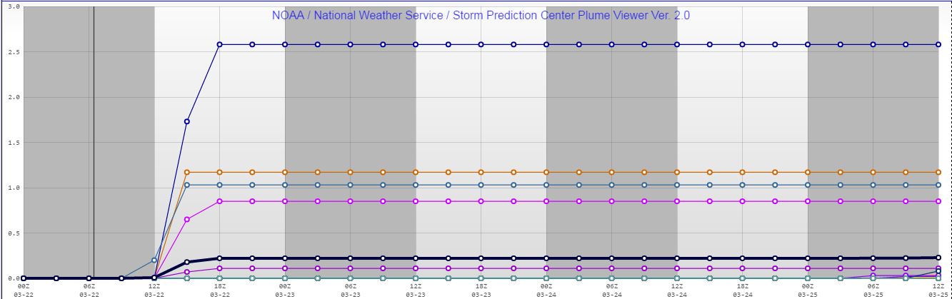
Now the largest problem remains is will the temperatures cool down enough to support snow. The models vary in this regard and there is a fine line as to whether or not snow can fall and then whether it will get heavy enough so it can accumulate on roads. The odds of rain changing to snow over the Inland Northwest look fairly good especially over Idaho and southern Spokane County and northern Whitman County. However a tougher question to answer is will the snow be able to accumulate on the area roads? If the snow gets heavy enough the answer is yes, however if not, most of the accumulations will occur on grassy surfaces. So once again lets look at the plume diagrams to see how much snow 27 different model runs produce over Spokane, Coeur d'Alene and Pullman.

Spokane plume diagram shows snow totals ranging from 0.0 - 2.5" with an average around 0.3" 


Coeur d'Alene plume diagram shows snow totals ranging from 0.0 - 5.3" with an average around 0.8" 

Pullman plume diagram shows snow totals ranging from 0.0 - 3.5" with an average around 0.5" 

Generally speaking, these values are on par with what the models were showing last night, however with the band moving further to the north, the snow totals in Pullman are trending lower. Motorists are still urged to check the latest forecast before venturing out in the morning and be prepared for a potentially snowy commute. Here is our latest snow forecast.

Snow forecast for Tuesday (issued 9 pm Monday )


1145pm Monday Update....the band of precipitation was beginning to take form. Our confidence is growing the moderate to locally heavy precipitation band will develop. Still not sure if heavy snow will accumulate.

1147pm radar imagery. Note heavier precipitation developing between  Davenport and Ritzville. 


Saturday, October 3, 2015

Is the end of fire season expected soon?

So while we can't argue that the worst of fire season is behind us, it should be noted there are still fires burning across portions of the Inland Northwest. Here's is what satellite information was showing on the last day of September:

MODIS Visible Satellite Imagery from 9/30/15

While these fires are far from the raging infernos we saw earlier this summer, it's still rather impressive for the end of September or beginning of October.  However, as we all know this year is different. First off, look at these precipitation totals since the beginning of April

Idaho Precipitation % of normal 4/2/15-10/1/15

Washington Precipitation % of normal 4/2/15-10/1/15
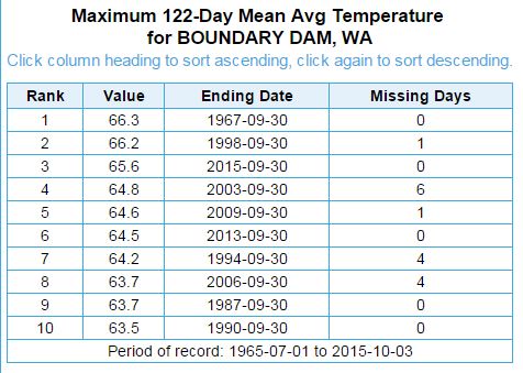
That is a lot of red and dark red shading over the Inland Northwest which correlates with meager precipitation amounts ranging 25-70% of normal. That's pretty dry. In fact, since the beginning of April through the beginning of October it was the driest period on record for both Spokane and Boundary Dam, WA (extreme NE corner of the state).

So combine the record dry conditions with nearly record warmth for both sites and it is no wonder the fire season has been so long. Here is a look at the temperatures for both sites.

So obviously record warm and dry conditions led to our active fire season, but unlike a typical year, things just aren't winding down as quickly as we are accustomed to. Climatologically, the days of active fires will be limited. We say that because the shorter days are leading to cooler temperatures and higher relative humidity levels  (both items are generally detrimental to good fire growth) while the chances for measurable precipitation are rising quickly. Climatologically the chance of measurable rain ranges from 20-25% over locations where the fires are currently burning. However by the end of the month those chances nearly double. So despite these facts, look at the latest fire danger ratings for the Inland Northwest:

Current Fire danger ratings
That map shows the fire danger is still high (yellow) or even very high (orange) across a sizable portion of the Inland Northwest, with moderate conditions (light green) found everywhere east of the Cascades. So what does that mean? According to the Wildland Fire Assessment System (WFAS) a high fire danger means, "All fine dead fuels ignite readily and fires start easily from most causes. Unattended brush and campfires are likely to escape. Fires spread rapidly and short-distance spotting is common. High-intensity burning may develop on slopes or in concentrations of fine fuels. Fires may become serious and their control difficult unless they are attacked successfully while small.

So is this danger level unusual for the beginning of October? Since 2006 (earliest year of  the graphical archive), the current fire danger has only been matched one time. That was in 2012. All other years saw low to moderate fire danger ratings across the area.


So what was the fire weather like in 2012? This satellite picture tells the story

MODIS Satellite imagery from 10/4/12

Just like this year, there were quite a few fires burning during the beginning of October. In fact, based on the satellite image, they were much bigger and included the Wenatchee Complex (southwest of Wenatchee) and the St. Mary's Misson Rd fire south of Omak. So what happened that year? The dry weather and fires continued to burn through the middle of the month, but several days of rain (not necessarily heavy) and cooler temperatures put an end to that fire season.

So what did the weather pattern look like for the end of that fire season? Well leading up to the end of the fire season, the upper-level pattern exhibited a large ridge parked right off the BC/WA coast with dry northwest flow over the region. Also, note the low-pressure area off the California Coast.

Early October 2012 500 mb pattern. 
So how does the pattern look for most of this week? Although it's far from identical, it does have some similarities, including the low near California, and the ridge over the Pacific Northwest.
500 mb pattern for Monday afternoon (10/5/15)
So what did the weather pattern that led to the end of the fire weather year in 2012 look like? The ridge broke down quite quickly and was replaced swift southwest flow into the Pacific Northwest and a deep low over the Gulf of Alaska. Again this brought cooler temperatures, periods of light rain (moderate in places), as well as significant cloud cover.
Mid-October 2012 500 mb pattern (Oct12-14)
How about this year? Is anything similar expected? Again although not a perfect match, there are some good similarities including a deep Gulf of Alaska low and deep southwest flow pointed into the Pacific Northwest from the eastern Pacific.
500 mb forecast for Oct 10, 2015
So how is our confidence in this solution and will this be the end of the fire season?  There are a few additional tools we can look at. One of the more interesting ones is called the NOMADS ensemble probability tool. This tool queries 21 GFS ensemble members or model runs and calculates the chances of any given parameter. Using this tool we can look at things such as what is our chance of seeing over a tenth of an inch of rain in a day?  When asking that particular question, here is the answer for the Grizzly Complex located over northern Shoshone County, ID.

The probability of seeing 0.10" of rain or more in 24 hrs over northern Shoshone County. 
So if you key in on the clustering of the blue bars, you can see that there is some consensus that by next weekend (10/10 and 10/11) that the weather pattern will support an increasing chance of rain (it peaks at 25% for the 24 hrs between 5pm Saturday through 5pm Sunday). Notice also that there is a small chance of light rain during the middle of the week.

Stay tuned and we shall see if this will truly be the end of a historically warm and dry fire season across the Inland Northwest.