Showing posts with label SREF. Show all posts

Monday, March 21, 2016

UPDATED....Is a significant snow event possible for Spokane,Coeur d'Alene or the Palouse late tonight and tomorrow morning?

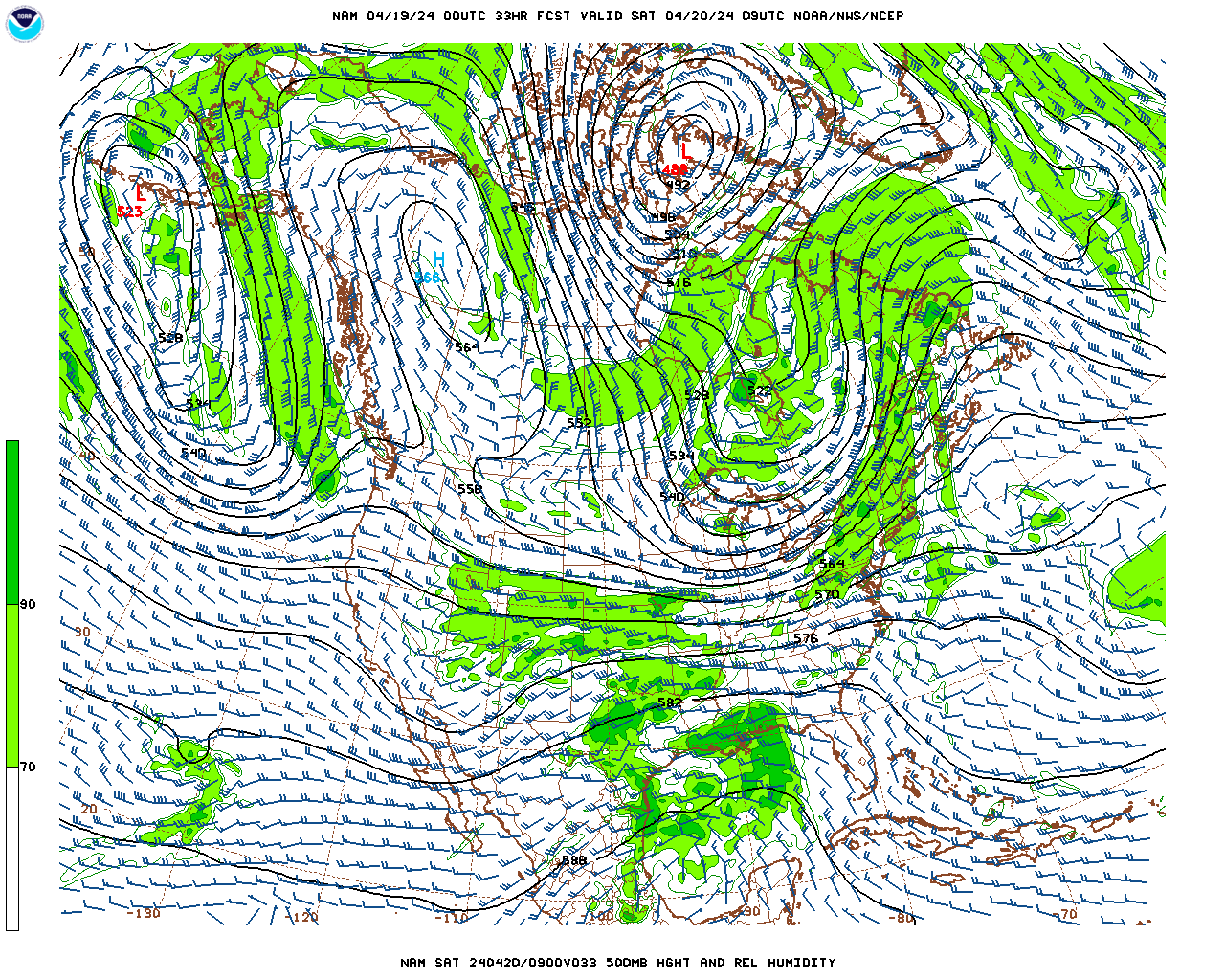
So as we talked about yesterday, an unusually tricky weather scenario looks like it will unfold over the Inland Northwest. So what are we fairly certain about? We are fairly confident that a slow moving upper-level low-pressure system will take up residence over the Inland Northwest and produce a band of moderate to locally heavy precipitation. The big questions to answer are where is this band going to set up and will it cool the atmosphere enough that we could see some significant snow. The setup producing the unusual event looks quite similar to what we discussed in our previous blog. We still expect to see strong lifting associated with a slow moving upper level low parked somewhere over eastern Washington. Notice the green shaded area (representing upper-level moisture) remains parked over eastern Washington and the central Idaho Panhandle through much of Tuesday.


500 mb pattern 2am Tue-5pm Tue
The lifting from the low will be accompanied by plenty of moisture and instability which should be perfect for producing a band of precipitation. Just how much precipitation are we talking about? A lot to say the least. The areas in purple represent totals between 0.50-1.00 inches of liquid and the reds and yellows equate to amounts between 1.00-1.50 inches. This is for the 12 hours between 2am through 2 pm Tuesday. Notice the band of heavy precipitation has eeked farther north than what we were looking at in yesterday's forecast and blog.

Latest 12 hr precipitation forecast 2am Tue-2 pm Tue

Previous 12 hr precipitation forecast for 2am Tue-2pm Tue

We still highly suspect that whatever verifies from a precipitation standpoint will more closely resemble the top two panes showing a heavy east-west oriented band vs the more poorly defined precipitation blob in the lower two panes.

Since the forecast is nearing in time we can also use one of our favorite tools called the HRRR (a rapidly updating model that runs hourly and can ingest current weather conditions). Let's see what the latest run of it says. The loop below is a simulation of what the radar is expected to look like. Green and yellow shading indicates where the heaviest precipitation is expected.

Radar simulation for Tuesday morning

So this also boosts our confidence that this event is going to occur. Each subsequent run of this model continues to show a similar radar formation (with small variations in location).

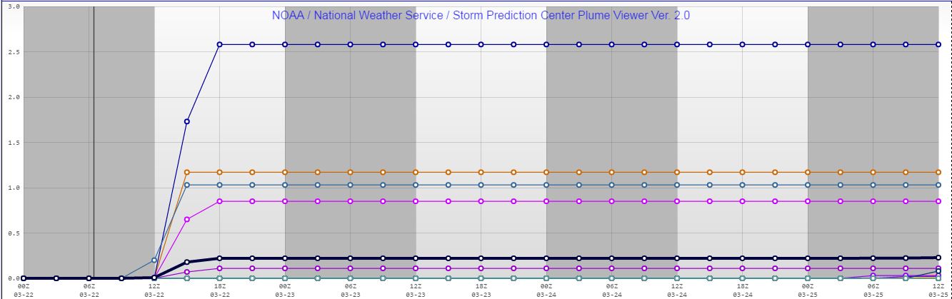
Now the largest problem remains is will the temperatures cool down enough to support snow. The models vary in this regard and there is a fine line as to whether or not snow can fall and then whether it will get heavy enough so it can accumulate on roads. The odds of rain changing to snow over the Inland Northwest look fairly good especially over Idaho and southern Spokane County and northern Whitman County. However a tougher question to answer is will the snow be able to accumulate on the area roads? If the snow gets heavy enough the answer is yes, however if not, most of the accumulations will occur on grassy surfaces. So once again lets look at the plume diagrams to see how much snow 27 different model runs produce over Spokane, Coeur d'Alene and Pullman.

Spokane plume diagram shows snow totals ranging from 0.0 - 2.5" with an average around 0.3" 


Coeur d'Alene plume diagram shows snow totals ranging from 0.0 - 5.3" with an average around 0.8" 

Pullman plume diagram shows snow totals ranging from 0.0 - 3.5" with an average around 0.5" 

Generally speaking, these values are on par with what the models were showing last night, however with the band moving further to the north, the snow totals in Pullman are trending lower. Motorists are still urged to check the latest forecast before venturing out in the morning and be prepared for a potentially snowy commute. Here is our latest snow forecast.

Snow forecast for Tuesday (issued 9 pm Monday )


1145pm Monday Update....the band of precipitation was beginning to take form. Our confidence is growing the moderate to locally heavy precipitation band will develop. Still not sure if heavy snow will accumulate.

1147pm radar imagery. Note heavier precipitation developing between  Davenport and Ritzville. 


Is a significant snow event possible for Spokane,Coeur d'Alene or the Palouse Tuesday morning?


Although the weather of late has been quite wet, the overwhelming majority of the precipitation has fallen as rain (or melting snow) in the valleys of eastern Washington and north Idaho including the Spokane/Coeur d'Alene area and the Palouse. That might change however as an unusual weather pattern materialises on Tuesday morning resulting in the possibility of significant snow. So what is the weather pattern which might lead to this unusual snow? To get significant snow in the valleys this time of year you need several things. First, you want to have a fairly strong upper-level trigger. In this case, we will be dealing with a slow moving upper-level disturbance or vorticity maximum.

500 mb pattern 2 am-2 pm Tuesday

The emphasis is on slow. The loop above shows the disturbance quite nicely between 2am-2pm Tuesday. The green area represents where the forecast model is placing the best moisture. Notice the feature also looks like a semi-circle indicating a tight circulation in the upper atmosphere which should lead to increased upward motion.

Another ingredient we like to see to enhance this upward motion is deep instability. This helps enhance the upward vertical motion between the ground and the upper atmosphere. So will the atmosphere be unstable? You bet. The orange and red shading indicates where we expect to see the most instability (however it's unstable everywhere across the region.
Lapse Rates through the mid-atmosphere 2am Tue
So couple the presence of the instability and the upper-level disturbance and here is where one model solution suggests we will see the greatest lift. Areas in purple and light purple are where the models expect to see the greatest ascent and thus the best potential for precipitation.
Upward motion through the mid-atmosphere 2am Tuesday

Finally, you need an atmosphere which is cold enough to support snow. This is the least confident part of the forecast. Model solutions are suggesting that the temperatures before the precipitation arrives early Tuesday will be above freezing, but then they slowly fall as the precipitation intensifies during the morning at least over a very small area (denoted in light or dark blue).

8am Tuesday Temperatures

So we have the ingredients in place for a heavy precipitation event (albeit fairly localized). Now the question is where will this band of precipitation set up and will it become heavy enough that it can produce accumulating snows in the valleys. That is a tough question to answer since there has been considerable model variability. What we can gather is more often than not the model solutions have depicted a northwest-southeast or west-east oriented band of precipitation similar to the two panes in top portion of the image below. Some of these amounts are quite impressive. The areas in purple show precipitation amounts above 0.75 inches and the red areas are showing more than an inch. So is it possible that most of not all this will fall as snow? It is certainly a possibility. 

12hr precipitation amounts forecast between 2am-2pm Tuesday
So just how much snow are we talking about?  Well here is a plume diagram showing 27 different model possibilities or solutions for the Pullman/Moscow area. While some of the models are hinting at a little more than a trace of snow, the most impressive solution is showing nearly 8 inches! The average snow amount from all the variations is just over 1" of snow.  For the Spokane area, the forecast is nowhere close to as snowy as for Pullman. The maximum snow forecast is around 2.25" but the average is around a quarter inch. That's a lot of variation, to say the least. 

Plume Diagram for snow for Pullman (Click image for larger view)


Plume diagram for snow for Spokane (Click image for larger view)

So what do we expect to happen? We are fairly confident we will see a band of moderate to locally heavy precipitation develop on Tuesday morning. Again the question is where will this occur and will the atmosphere be cold enough to support heavy snow? The other variable is will the ground be cold enough allow accumulations to occur on the roads? If the snow gets heavy enough (quite possible) we suspect the answer will be yes. Motorists are urged to prepare for the possibility of winter driving conditions for the Tuesday morning commute. Chances are the afternoon commute will be much easier as any threat of accumulating snow diminishes. Hopefully, as the event nears our confidence will grow as to where we expect to see the greatest risk of significant snows. 


Friday, April 3, 2015

Will the Inland Northwest see snow on Sunday night and Monday?

The Spring thus far has been fairly mild, and as a result we haven't had to worry about the threat of snow. The temperatures for March were some of the warmest if not the warmest on record for many locations.

March temperatures
But all weather patterns come to an end at some point and this will be no exception. So here is what the upper-level weather pattern for most of the month of March looked like. It showed a rather persistent ridge focused over the West Coast with the storm track nudged well north of our area
Mean 500 mb pattern for March 1-March 29th
However since the end of the March and continuing into April, the upper-level ridge has shifted to our east, allowing the upper-level trough to nudge into the eastern Pacific and the storm track to push through the Pacific Northwest.
Mean 500 mb pattern March 30th-April 1st
This has resulted in more typical springtime weather for the region including significantly cooler temperatures, and numerous afternoon/evening showers and thunderstorms accompanied by an Inland Northwest springtime staple: graupel. But despite the cooler weather, most of the valley locations, have yet to deal with snow. That might change though with the arrival of the next significant weather system. The model solutions are rather convincing that this system will arrive sometime between late Sunday night and Monday as the deep offshore trough heads inland.

500 mb pattern for Monday morning
Referring to  the map above, it suggests most of the upper-level energy will remain poised off the southern Oregon/Northern California coast, however look closely over extreme northeast Washington/north Idaho and notice the small yellow circles. These indicate the larger trough will also contain several small shortwave troughs.  If these troughs are accompanied by enough moisture and instability they can trigger small bands of moderate to intense precipitation, or what we
meteorologists term meso-banded precipitation or mesobands. Even more intriguing is these mesobands can often allow snow to fall (and possibly accumulate) at much lower snow levels than expected.

The odds are quite good that the region will see mesobands of precipitation form, the big question is where and what will the impacts be?

To answer the first question of where will these bands form, we first need to look at the positioning and track of any surface low tracks. Here is a look at four weather models we typically utilize and where they place the low (and resultant precipitation) as of 5am Monday morning.

4 model solutions with surface low position and 6-hour precipitation valid 5am Monday
As you can see above, all four models have a surface low located over the eastern third of Washington or north Idaho, however, the exact positioning and strength of the low is quite variable. The solution in the upper left corner is by far the most impressive solution. It has the strongest surface low (1000 mbs) and the heaviest amount of precipitation. The purple colors in this image represent precipitation amounts between 0.50-0.75" in a six-hour period. The other model solutions show a weaker low (1005-1006 mbs) and much lighter precipitation amounts.

When there are wide disparities between our core models we like to defer to ensemble modeling. This is where we take an initial model run and add small perturbations to the mix. The perturbations begin small but with time tend to grow. When the models cluster the positioning of a low, this boosts our confidence in the forecast, whereas if lows are strewn haphazardly across the region, our confidence is quite low. So here's a look at the SREF positioning of the surface lows for Monday morning.

SREF Surface low positions for 5am Monday


Although there are plentiful lows (L's) found across the Inland Northwest there is a wide scattering of their positions. The fact that there are plentiful lows is good from a standpoint of there is fair confidence of an event occurring. However, the wide scattering of the L's lowers our locational confidence significantly.  We can also look at the mean of all the low positions and the mean of all the precipitation data to come up with a preliminary snow forecast. In this case, the SREF is showing this as the mean snowfall for the 12hrs ending at 11 am Monday.

Mean 12hr snowfall ending 11am Monday
While these values themselves are not impressive (1-2" for the areas shaded in green) the fact that this model is showing such widespread snow is noteworthy. Another interesting thing we can look at from the SREF model is a plume diagram which shows all the suite of model solutions on one chart. So given the map above, it would seem locations north and east of Spokane as well as near the Cascade Crest would see the best chances of snow. So to hone our forecast a little more we will look at some plume diagrams to determine potential snow amounts. The first we will refer to is for Sandpoint.

Sandpoint snow plume diagram
Each line on this plot refers to one particular member of the SREF ensemble. In this case, most of the solutions are showing some snow on the right side of the diagram. The mean of the runs is denoted by the black line which is indicating a mean snowfall of 2". More impressive (but not probable) is the pink line which shows snowfall totals exceeding 8".  How about the plume diagram for Spokane?

Spokane snow plume  diagram
Even the Spokane plume diagram is showing some snow. Nothing compared to Sandpoint, but some snow nonetheless. The mean snowfall is right around an inch, however, there is one run which shows  totals nearing 5"!

Now despite these snow forecasts, the other factor to consider is how easily will this snow accumulate on the ground? The temperature forecast for late Sunday night and early Monday morning is for readings in the lower to middle 30s. Certainly cold enough for snow, but perhaps not enough for significant accumulations, especially in the Spokane area. After sunrise, temperatures will slowly climb into the upper 30s to middle 40s which suggest snow accumulations are even less plausible except perhaps on grassy surfaces. 

So in summary we are fairly confident a deep but compact surface and upper-level low-pressure system will track through the Inland Northwest producing locally moderate to heavy precipitation some of which will fall as snow. Where it will go and what time of day it hits will be critical for determining what it's impacts will be. Winter driving conditions are certainly possible for the Monday morning commute, especially north and east of Spokane. In the meantime, stay tuned to our latest National Weather Service Forecasts and don't put away your winter clothes quite yet. 

Friday, October 31, 2014

How's tonight's trick-or-treat weather looking?

Yesterday we discussed what the odds of a wet Halloween would be and whether or not the holiday revelers would need to accessorise with umbrellas or additional rain gear. Well, now that the event is nearing our confidence in where rain will fall during the evening is growing. First lets look at the latest satellite picture. The feature of concern is the north-south band of clouds and moisture (while and green band) associated with a cold front (blue dotted line). This cold front is slowly working its way to the east and will likely it's trek through the evening.

3pm Water Vapor imagery with approximate cold front position in blue

So while the satellite was showing the cold front moving slowly to the east, what did that translate to in regards to precipitation? As you notice on the radar loop below, much of the preciptation has shifted east of the Cascades and Yakima (aside from some isolated showers over western Washington and Oregon) and was making a slow northeast path toward Spokane and northern Idaho. Based on this, it seems certain that rain will fall this evening over these locations, however the front is still expected to weaken during the evening. So where do we expect to see the best chances of rain during the evening between 6 pm and 9 pm?

Radar Mosaic from 130pm-300pm

To answer this question we will refer to the same ensemble forecast as yesterday (SREF model) as well as some hourly model guidance (HRRR model).

According to the SREF model, the best chances will occur over the extreme northeast portions of Washington and adjacent portions of north Idaho (areas shaded in purples and reds). This would impact trick-or-treaters in Sandpoint, Bonners Ferry, and possibly Colville. However notice the SREF isn't expecting much chance of measurable precipitation over Spokane or Coeur d'Alene(greens are 20% chance of less). This is because the front is still expected to stretch and weaken as it moves to the east this evening. The other area of concern for rain is over the extreme southeast corner of Washington, near the Blue Mountains and Pomeroy. Based on current radar trends, this seems overdone, but bears watching. Let's now check on the hourly HRRR guidance to see if it agrees with the SREF.
SREF measurable rain chances from 5pm-11pm

So below you will see the hourly HRRR model data for the period between 6pm-9pm. The images represent what the radar might be showing during those times. Greens and blues show where the model thinks there will be rain. Generally speaking it agrees quite well with the SREF, by keeping most of the rain to the north and east of Spokane. In fact, most of the rain generally remains fixed over northeast Washington and doesn't really hit north Idaho in force until after 8pm, and by then the front looks quite weak. Also notice that over southeast Washington the forecast looks dry until 9pm and then later into the night (not shown here).

6pm simulated radar from the SREF

7pm simulated radar from the SREF

8pm simulated radar from the SREF

9pm simulated radar from the SREF
Does this mean we can count on a dry evening over Spokane and Coeur d'Alene? We don't think so (the HRRR is showing a few tiny specks of green and blue around the area), The front has enough moisture and lift to produce some light rain in this area, but it won't likely amount to more than a few sprinkles and thus rain gear will be optional.

Rain or not, one thing is certain, this will be another mild Halloween. Much more so than what the region endured back in 2002. That evening, the holiday revelers had to endure temperatures in the teens. 2003 was not much warmer. However, since 2007, every Halloween evening has been fairly mild. Here's a look at trick-or-treat temperatures since 2000.

Halloween temperatures at the Spokane Airport since 2000


Wednesday, January 8, 2014

Snow, Rain, Wind, (and Thunder?)

Yesterday's weather system brought a nice 1 to 3" of snow to many locations.  You can see an extensive list of snow reports on the National Weather Service website.  Now we have Storm #2 arriving 24 hours later.  This one will be a little different in a couple of ways.  First, this storm is a little wetter and more extensive than the first.  This means more people will see precipitation.  Here's the radar forecast from the HRRR model valid at 5pm this evening:


5pm radar forecast from the HRRR model

This is a forecast from a computer, not an actual radar image.  But it gives you an idea what the radar will look like around 5pm.  And just about everyone in the Inland NW will be seeing some sort of precipitation at this time.  Which leads us to the other difference.  While Storm #1 was all snow, this one will be more of a mixed bag of rain and snow.  The HRRR forecast for precipitation type at 5pm is shown below.


5pm precipitation type forecast from HRRR
This graph is a little hard to read, but the horizontal blue lines represent snow, while the vertical green lines are for rain.  The HRRR expects the precipitation by 5pm to be rain south of a line from Deer Park to Grand Coulee.  This includes Spokane and the Palouse.  The precipitation may initially start in the metro area as wet snow, but it won't be able to accumulate much and will change to rain later this afternoon. Also notice there are some small pockets of red scattered around the region. This represents a chance of freezing rain. If freezing rain really does occur it will be rather isolated and likely quite brief. 

Here's the storm total snow forecast from the National Weather Service.


Storm total snow ending 4pm Thursday


Most of the valleys across the north (Republic, Colville, Sandpoint) will see all snow and pick up 2-6" of snow, while the mountains will receive up to a foot.

Storm #3 will follow on Thursday afternoon/evening this will be a weaker system.  It will once again bring rain or snow to Spokane and the Palouse while the northern valleys will pick up a little more snow.

Storm #4 is still taking shape but it consistently looks like it will be the strongest of the bunch.   Today's GFS model forecast backed off a little from it's previous forecast, while some of the other models came out a little stronger today.  As a result, they're all in very good agreement at this time.  We often take this as a sign to increase our confidence in the forecast.  Even though they all agree, could they all be wrong?  Yes, but the odds are growing increasingly slim.  

Here's a breakdown of how this storm will unfold:
  • Precipitation will spread over the area on Friday around or shortly after sunset.
  • Spokane and the Palouse will see rain from this storm, with a possible mix of snow at the onset.
  • Saturday morning will be rainy and breezy.  Spokane will be in the lower 40s by sunrise and top out in the mid 40s during the day.
  • The northern valleys will start as snow and will accumulate a few inches.  They will gradually change to rain overnight.  Colville will probably change to rain before midnight, while Bonners Ferry could hold on to snow until Saturday morning.
  • The cold front will move through the area during the middle of the day.  Behind the front winds will really blow.  Below is our forecast peak winds for Saturday.  Areas in white can expect gusts in excess of 50 mph.

Peak wind gusts expected on Satuday

We will likely be issuing Wind Advisories for much of the area and possibly High Wind Warnings.  You'll want to stay tuned to this forecast.

Here's a couple of other things to consider with this storm.  The rain along with the melted snow won't be able to soak into the ground since the ground is solidly frozen (from our early December cold snap).  So expect some water  ponding, even on your lawn.

The other interesting tidbit is the outside chance of a thunderstorm.  Thunder?  In early January?  Yes, it's happened before, and this is pretty much the classic set up for it:  warm moist air ahead of a strong cold front.  Below is the SREF model probability of thunderstorms. 

24 hr thunder chances ending 10pm Saturday. 
You can see a small area of 10% over southeast Washington.  If thunder does occur, we don't expect to see hundreds of lightning strikes. However a few claps of thunder are a possibility especially over southeast Washington and the southern Idaho Panhandle, including Pullman and Lewiston.