Showing posts with label north Idaho. Show all posts

Friday, November 4, 2022

Storm Part 2...Will your house have electricity in the morning plus a look beyond?

There's a good chance of seeing multiple power outages tonight with our upcoming wind storm.  And depending on how many outages there are, our much-appreciated hard working utility folks may not have all the power back on before you get up Saturday morning.  As such, you may want to make some contingency plans.  It would be a good idea to charge your battery powered devices this evening just to be safe. 

Round 1 of our storm series is over. The main result of it was heavy snow which fell over many parts of the Inland Northwest overnight and into this morning.  It is very unusual to have this much snow this early in the season, let alone for the first snow of the season. Here are the morning snow totals.  Since it snowed much of the morning, these totals will likely increase from what's posted here.


Now it's time to get ready for Round 2 and it could be a doozie: the wind storm.  The various computer models have their usual disagreements, but they're all saying it's going to be windy tonight.  One chart we often look at for wind events is the 850 mb wind forecast.  Think of this as the winds about 3000-5000 feet elevation.  Usually a wind of about 50 knots (58 mph) will get our attention.  In this instance, the GFS is forecasting 65 to 78 knots of wind tonight!  Other models so something of a similar magnitude.

850 mb winds for 11PM Friday

So the question is: can that wind that is 3000-5000 feet overhead mix down to the ground?  The answer is quite complicated and difficult to answer.  Meteorologists often struggle with this a lot.  In some instances, those strong winds above us stay above the ground and we never feel them.  But there are situations where those strong winds do make it to the surface.

One of those mechanisms is cold fronts.  And that's exactly what we'll have moving through our area tonight.  The front is moving west to east, and will go through Spokane around 1am tonight.  Before that, the rain in the Spokane area will taper off around 6pm, and then the winds will begin to crank up.  It will be windy with gusts up to 50 mph late this evening and then the front plows through. We still think there is a good chance that when the front goes through, we will see wind gusts in the 60-70 mph range for some locations.  The damaging winds should begin to taper off  before sunrise Saturday.

Here's the peak wind forecast.  Keep in mind that the valley locations like Colville and Republic may not see the highest wind speeds, but they have more trees to potentially knock down and thus produce more power outages. 


So what can we expect from an event like this?  At this point, there are some similarities between this event and the 13 Jan 2021 event.  That event had 850mb winds of 57 knots just before the cold front came through, which resulted in a gust to 71 mph at Spokane Airport.  But similar to tonight's event, the strong winds only lasted about 3 hours.  Still, the tree damage was significant, and power outages lasted for several days in some locations.


After the wind storm, we aren't done with the active weather, we still have Rounds 3 and 4 to contend with. 

Round 3 promises to deliver more snow, and in some cases it could be significantly more than what we just saw. The heaviest snow possibilities are honing in on north-central Washington.  The surface low will track south of us, which favors that part of the Inland NW due to easterly low-level winds pushing into the Cascades. This will cause rising air over much of that area, rather than the more typical downslope/rain shadow effect.  Snow should start there on Sunday morning.

Surface low position (off Vancouver Island at 11 am Sun) and precipitation

But since this low is tracking south of us, the front will move very slowly across the region.  It won't reach extreme eastern WA and the Panhandle until 24 hours later, Monday morning.

Surface low position and precipitation as of 11 am Monday

Here's the current forecast storm total snow for this event.  


And lastly, Round 4 will be the unusually cold temperatures that move into the region behind this storm.  There's a good chance that some locations will break daily records.  Here is a list of the record highs which could be broken (denoted in yellow):


As well as the record lows (denoted in yellow):


If there are widespread power outages from the wind or upcoming snow event, the cold temperatures next week could have a much bigger impact than they usually would. 


Sunday, May 31, 2015

Does Monday still look like a severe day?

A few days have come and gone since our last post about the potential severe weather event for the first day of June. So how are things looking now that the event is nearing? Well according to the water vapor imagery below, it's looking pretty good. See the swirl off the northern California Coast? That's the deep low-pressure system which will deliver the active weather as it moves toward the Inland Northwest. Why is this low important? Well for a good thunderstorm day we need three key ingredients: lift, instability, and moisture. The low will provide us with the first ingredient.

Animated water vapor imagery. Note the swirl off the Northern California coast. 

The models are very consistent in taking this low from its current position off the California Coast toward the Washington/Oregon border by afternoon and then toward the Washington/BC border by evening. This pattern resembles the typical negative tilted pattern we associate with severe weather in the Inland Northwest. The track of the low will ensure that the region will be subject to strong lifting potential beginning in southern Washington and central Idaho in the morning and spreading northward through the day. 

500 mb forecast with precipitable water forecast


Notice the shading in the 500 mb map above? That represents the precipitable water forecast. The greens, blues, and purples depict where the juiciest air will be located, Initially the pool of moisture, currently over far northern Oregon, will shift northward tonight and then become enhanced with even more moisture from the incoming low. How much moisture will we see? We forecast that using  a parameter termed precipitable water. Precipitable water is a figure used to represent how much water the atmosphere is holding. The precipitable water forecasts are expected to reach  values are forecast to exceed an inch over portions of the Inland Northwest by afternoon. How unusual is that? According to the graphic below, it would be placed in the 97.5-99th percentile for this time of year. So it will be far from typical. 

Precipitable Water anomaly
So with the two key pieces in place, what about the third, instability? Well it looks like that piece of the puzzle will be realized as well. If you recall our previous blog post, one of the ways to measure potential instability is looking at the lifted index values. If we see negative lifted index values, that indicates potential instability. So as early as 5 am, we begin to see some of this instability. Notice the yellow and orange shading over southeast Washington? This is enough instability to support thunderstorms even without the benefit of daytime heating. 
5am Monday Lifted Index Forecast
How about later in the day? Suffice it to say the instability will not be lacking. The entire region is expected to see negative lifted index values, with the best instability represented by the -6 to -8 values over extreme eastern Washington and north Idaho. That's about as good of a lifted index as you can expect to see over the region. 
5 pm Monday Lifted Index Forecast
So with all the pieces in place what would we expect to happen? We think there will be a band of showers and thunderstorms early in the morning spreading across the Washington/Oregon border, which should slowly work their way northward through the morning. How extensive this band will be remains rather uncertain. One of the weather models is forecasting the radar to look like the image below. Notice the nice cluster of showers and thunderstorms near the Blue Mountains in SE Washington. This coincides nicely with the good pocket of instability forecast by another model.  

7 am simulated radar image

By midday, this band is expected to drift farther north, but could lose some of its definition and strength.  
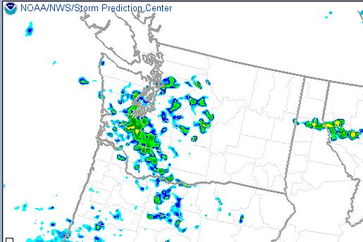
11 am simulated radar
However, the first band which moves through will further moisten and destabilize the atmosphere before the strong upper-level disturbance tracks toward our region. So what will the afternoon look like? This is far from certain, and there are as many answers as there are high-resolution models. Here's just one of the forecasts for 5 pm. 

5 pm simulated radar
That is a pretty impressive simulation with strong thunderstorms located across the northern portions of Washington as well as in the southern Idaho Panhandle. However recall that the best instability (or lifted index values) were located over the Idaho Panhandle. So we have better faith in the eastern portions of this radar simulation verifying. Another thing we can look at is an ensemble of simulated radar returns. The image below shows where the greatest risk will be for the biggest thunderstorms (chances of having a 40 dbz or stronger radar echo). The regions shaded in purple have the best chances (over 90%) followed closely by the reds (over 70%). This would highlight two areas. The Cascade crest and over the southeast corner of Washington and the southern Idaho Panhandle.
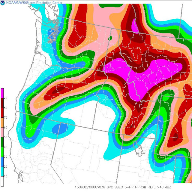
Ensemble chances for 40dbz or higher echoes
So what will the main risk of severe weather involve tomorrow? Based on the instability, the biggest risk looks to be large hail. If we look at the model soundings they are likely a little too moist to support widespread wind damage, however, we still expect to see some strong wind potential with a few of the storms. 

So what is the typical weather we experience with this type of upper-level pattern? We can utilize a fascinating tool produced by the Cooperative Institute for Precipitation Systems (CIPS) at Saint Louis University. They created a tool that makes an analog of the 15 closest weather patterns (since 1980) to what the forecast weather pattern is supposed to be. So below we see the forecast for tomorrow in red compared to the mean of the top 15 analogs (or pattern matches). This looks like a pretty good fit.

500 mb forecast for tomorrow (red) plotted against the 15 top weather analogs since 1980
So what weather was experienced on those days? Interestingly enough, quite a bit. Of those 15 days that matched Mondays expected weather, there were widespread severe reports. Most of them were related to hail, but a good sample of the reports were related to wind as well. Also, notice there were 3 tornado reports in the Inland Northwest. We do not expect to see tornadoes on Monday, as the wind patterns are not quite right to support violently rotating storms, however, they have occurred in this weather pattern before. 
Severe reports from the top 15 analog days to Monday's weather pattern

The other risk we see tomorrow will be for flash flooding. The storms which develop tomorrow will obviously contain copious amounts of moisture. And more importantly they could be slow movers. 
The risk of heavy rains will likely continue through Monday night before tapering off. Here's a look at the 24-hour precipitation forecast from 4 different weather models.

Precipitation forecast from 11am Mon-11am Tue
That's a lot of precipitation (purple amounts are above  0.75") and there is a fairly consistent message that the bulk of it will occur across the northern quarter of Washington, the Cascade Crest, and over the Idaho Panhandle. Since much of this will be attributed to thunderstorms, there is likely to be a high variability over short distances, with some areas likely to receive much heavier amounts. 

Stay tuned for updates to the forecast as this will likely be a very active weather pattern. 

Monday, May 18, 2015

How is this Memorial Day Weekend looking weather-wise?

Last year at this time, we composed an extensive blog discussing the connotations associated with Memorial Day weekends in the Inland Northwest.  In many parts of the country, this weekend typically kicks off the summer season. However here in the Inland Northwest that really isn't the case, due to continued cool and unsettled weather. So is this year going to fit the weather mold, or will we see warm and dry weather?

Before we delve into this year's weather scenario, lets look at what the typical weather pattern is for this time of year. Looking at the mean 500 mb (18k ft MSL) maps below we see that the typical weather pattern is to see moist southwest flow pointed into the Pacific Northwest with a ridge setting up just downstream of the Continental Divide in western and central Montana. 


500 mb mean map 5/23-5/31
So what about the temperatures associated with this average pattern? Here's  the average temperatures for a couple locations as well as the average chance of precipitation:

So not bad. An average high around 70°F with rain expected on roughly 1 out of 4 days doesn't sound too terrible. But that's climatology and this weekend's weather could vary significantly from the norm. Why you ask? Well, let us take a look at the 500 mb pattern for this weekend to get an idea what sort of weather we might be dealing with. First off, here's a look at the weather for Saturday. 


GFS 500 mb heights for Saturday
This does not look promising if you enjoy plenty of sunshine and warmth. Note the closed low-pressure system (yellow L) centered over northwest Washington. Low-pressure systems like this are typically associated with cool and unsettled weather, especially if your are under or near the low. But this is only one model run. Surely there are other ideas out there in weather land. Well, here's a look at 4 distinct weather models for the same time period.
500 mb pattern from 4 different weather models for Saturday
Notice all these model runs place a low somewhere over the Pacific Northwest. That raises our confidence that the weather will be cool and unsettled over portions of the region, but maybe this unsettled weather will only last for a day. So let us take a look at the Sunday weather pattern.

500 mb pattern from 4 different weather models for Sunday
If the upper left model solution verifies (the GFS), the Inland Northwest could really be stricken with another cool and wet day. The other model solutions would hint at some modest improvements, but far from what we would deem summer like weather. How about Monday then?

500 mb pattern for Monday
The upper left solution (the GFS) still keeps the low parked over Washington while the others either drop it south of the region or weaken it. We shall see. But what if the GFS solution were to verify? What would our weather be like? If you love rain, well then you will love this forecast. Here's a look at the total precipitation forecast for Saturday and Sunday.
Rainfall forecast for Saturday and Sunday
The swath of red shading indicates rainfall amounts in excess of an inch. This includes Spokane, Kellogg, Coeur d'Alene, Pullman, Lewiston, Banks Lake, Lake Roosevelt, and Colville. If you look even closer there are a few locations which are expected to see in excess of 2 inches (shaded in tan)!
Now that is a lot of rain, regardless of the time of year. If the precipitation were to materialize, it would equate to our wettest Memorial Day weekend since 1997 and the second wettest on record (since 1970). So what is our confidence level in this precipitation panning out at this point?

Another tool we can look at in addition to just a few deterministic model runs is from an ensemble forecast approach. This is where you look at multiple model runs (initialized from the same model) and try to gather where the forecast confidence in the precipitation swath is greatest. Using this approach, the news isn't great either.

NAEFS/GEFS Ensemble precipitation amounts for the 48 hrs ending Sunday Afternoon
Without delving too deep into the specifics of the image above, the black lines depict the average precipitation amounts from the ensemble mean precipitation forecast while the green and blue shading (well any shading really) is bad if you like dry weather.  Notice the black lines hint at a swath of precipitation extending from southern British Columbia to the central Idaho Panhandle. The green and blue shading suggests the 48-hour precipitation amounts are in the 99-99.9% percentile for an early April-early July event. In other words, it is a 1 out of 100 or 1 out of a 1000 event for this particular time of year! There is even a small area of pale blue which hints that rain of this magnitude for this time of year has not been experienced since between 1985-2011!  This map suggests the GFS isn't entirely alone in forecasting a wet weekend, but we would like to see much better model agreement before buying off on this solution.

Now, if the rain does materialize, what impact will  this have on our temperatures?
7-day Spokane Forecast
Our current forecast is showing highs above average through the workweek with a cooldown by the weekend. Notice by the weekend we are forecasting highs right around 70 each day. That's not bad. Right around average actually. But we discounted the wet GFS solution. What if the GFS were to verify? How warm would it get then?


7-day temperature meteogram for Spokane
See the green line on the chart above? That is our official NWS forecast. However the blue lines (from the GFS) show the highs on Saturday could struggle to escape the mid-50s on Saturday and then slowly rebound into the lower to middle 60s for Sunday and near 70 on Monday.

Stay tuned to later forecasts this week to see how wet this weekend might really get. In the meantime, you might want to procure yourself one of these if you have camping plans this weekend.


Thursday, January 22, 2015

Spring Skiing in January?

If you've looked at the forecast lately, you'll notice that we're expecting warmer temperatures next week.  Temperatures are forecast to be in the 40s, with even some lower 50s in places (i.e. the Palouse and Lewiston area).


Why will it be so warm?  Very strong high pressure will develop over the western US in the next few days.  But we often see that.  So what's so special about this?

The image below shows the temperatures at about 5000' above sea-level this morning.

Temperature at 5000 feet MSL on Thursday.


You'll notice that the warmest air (red shading) is over California, as well as in the lee of the Canadian Rockies.  Now here's the same image on Saturday afternoon:

Temperature forecast at 5000 feet MSL Saturday

Notice those bright red colors off the coast of northern California?  Where did that come from?  The wind will be "offshore" at this time, which means it will be blowing from the northeast, coming from Nevada and eastern Oregon, to the Pacific Ocean.  As it does this, it descends from the Sierra Nevada mountains down to sea level.  Air that descends warms due to compression.  So this warm air didn't move here from somewhere else, it was created by the wind flowing from the Sierra's (e.g. 8000 feet elevation) down to sea level.

Now here's the forecast of what will happen to that warm air on Monday:


Temperature forecast at 5000 feet MSL Monday morning

You can see that the warm air has spread northward, along the coast, and into the Inland Northwest.  

OK, so just how warm are we talking?  Well, in addition to keeping track of all of the record high and low temperatures at various cities, we also keep track of historical temperatures on our weather balloons.  So here's the January record high temperatures at 5000' MSL for various western locations, along with the computer model forecasts:


Site
Max 5000’ MSL Temperature
Model 1
Model 2
Model 3
Oakland
19°C
18.3°C
18.3°C
18.2°C
Medford
18°C
17.6°C
17.2°C
17.6°C
Salem
19°C
15.5°C
18.9°C
18.5°C
Quillayute
16.5°C
11.3°C
16.3°C
14.8°C
Spokane
14.5°C
11.2°C
12.6°C
14.1°C


The three models differ a bit in their forecast, but they all have very warm temperatures at 5000'.  Some records (going back to 1948) could be broken.  How warm are these?  The forecast of 14.1°C at Spokane, if it verifies, would be the same as what we normally see on April 6th!!!

So what does this mean?  The answer is somewhat complicated.  Here's the forecast high temperatures for Monday:


These are about 10 degree above normal for the end of January.  But this forecast could easily be very wrong.  You'll notice that much of the western Basin (i.e. Moses Lake), and the northern valleys (e.g. Omak, Colville, Bonners Ferry) are in light blue (40-45F) while the mountains (e.g. the area between Republic and Colville) are in green (45-50F).  What gives?

The northern and Cascade valleys have snow on the ground.  Any melting of snow could lead to fog and low cloud formation.  And this would keep the valley temperatures cooler (i.e. little or now sunshine).  But if that fog doesn't form, then the temperatures could easily be 10 degrees warmer than forecast.

Typically, for a mid-winter warm spell, we need wind.  The wind helps to mix the atmosphere, taking warm air aloft and mixing it with the cold air near the surface.  But in this case, there won't be much if any wind.  So we won't have any "mechanical mixing" to stir the atmosphere. The sun will have to do all the work by itself to warm up the near-surface temperatures.  With the low sun angle of late January, this is a tough task.  Not impossible, but difficult.

Meanwhile, the mountains will be above any fog formation and they should see abundant sunshine.  So confidence is high that they will be warm.   Here's the minimum temperature forecast:


Notice that the mountains are as warm as the valleys?  The mountains won't just be warm during the day, but they'll probably be above freezing during the nighttime hours as well.  And this will likely last for 3 or 4 days.  A week cold front in the middle of next week will cool things down some, but it will still be warmer than normal for late January.

So we'll get a taste of early spring next week, especially in the mountains.  There's a big bust potential for the valley temperatures, especially north of I-90.  But if you're going skiing, make sure you bring the sunscreen and don't over-dress.


Monday, December 22, 2014

Odds for a White Christmas: Update

OK, we're only 3 days away from the Big Day, and snow is still hard to come by in my Inland Northwest locations.  Is there any hope for a White Christmas?  Here's the current snow depth analysis:


Pretty pathetic.  Folks in the Cascades are doing well, as are those in some of the northern valleys (e.g. Omak, Republic, etc).  Otherwise, lots of bare ground.  

Just to refresh your memory, here was last year's snow cover at this same time. Not stellar, but better than this year.


But there's still time to change this, right?  Actually, the answer is "yes", for some locations anyway.  As we've been discussing in earlier blogs, the computer models have been suggesting a Christmas Eve storm for over a week now, but they've been waffling on the exact timing, track, etc.  And these small differences play a HUGE role in who will get precipitation, and in what form will it fall.  But now, the models are in fairly close agreement. So let's take a look at what they're saying.

Below is the GFS forecast precipitation for the 12 hours ending 4pm Wednesday.


While this looks encouraging, unfortunately almost all of this will fall in the form of rain.  Snow levels during the morning hours will be around 6000' but will rapidly fall through the day as cold air moves in from the north.  Can the snow levels drop all the way to the valleys before the precipitation ends?  Maybe, but this is typically a poor pattern for valley snow.  And even if it does snow in the valleys, it will have a hard time accumulating on the ground during the afternoon/evening hours.

Here's the probability of 1" or more snowfall on Christmas Eve. 


Things are looking up for folks in the Idaho Panhandle.  Meanwhile things look bleak for locations in central/eastern Washington, with locations west and south of Spokane having next to no chance for snow.

So, looks like a brown Christmas for many folks.  The interesting climate tidbit in all this is that we could set an obscure record at Spokane.  The latest that it's ever taken for the Spokane Airport to have it's first 1" or greater snowfall from one storm is Dec 24th 1976.  Unless the forecast changes in a hurry, we'll break that record.  But not by much.  Why you ask?  Because it's is now looking very good for a decent snow event after Christmas.

Here's the 24-hour precipitation forecast from the GFS ending Saturday evening:


Looks similar to the Christmas Eve storm, right?.  The difference is that just about all of this will fall in the form of snow instead of rain.  The reason is that while the Christmas Eve storm might not bring much snow, it will bring colder air.  So by the time this second storm arrives, we'll be much colder.  Different models have different amounts of snow, but in general they all have a solid 2-4" for most locations with the potential for higher amounts.

Here's the snowfall forecast from the NAM (red) and GFS (blue/purple) for Spokane. 


There are different forecasts here using different techniques.  But in general they give a similar message.  Snow will start Friday evening and continue into Saturday evening.  The ECMWF (not shown) has a similar story, but doesn't start the snow until Saturday morning and continues it into Sunday.  Either way, there is the potential for several inches of snow.

It's too early to hang-your-hat on this forecast.  But one of the things we like to see is that each model forecast is similar to the previous one (GFS runs every 6 hours, ECMWF every 12).  And they've been saying a similar message for about the last 24 hours.  So that's a good sign and gives us confidence that this forecast could indeed pan out.  But the overall pattern for this storm isn't necessarily a favorable one for heavy snow in the Inland Northwest.  The mountains will almost assuredly pick up some snow from this, but the lower elevations might not see much. Stay tuned to the forecast, especially if you plan to travel this weekend.


Wednesday, December 17, 2014

Are the chances of a White Christmas improving?---UPDATED 12/18/14

...Here's an update to yesterday's blog. We replaced the images with the latest weather forecasts...  

 Since our last post, we have gotten a little more resolution on the prospects of seeing a White Christmas across the Inland Northwest. But before we answer that question we need to deal with a weak weather system tonight and Friday and then a much stronger system for the weekend. As of our latest forecast (issued 3pm Thursday). Tonight and Fridays weather system is calling for light snow, mainly confined to the mountains. Valley snow chances will be reserved for the Cascade valleys, Okanogan Valley, and a small part of the Waterville Plateau. These locations will generally see amounts ranging from 1-3 inches with locally heavier amounts near the Cascade Crest. There will likely be some travel concerns going over the Cascade passes.


Snow forecast for tonight-Friday

The storm system for Saturday and Sunday stands a much better chance of producing significant snowfall as it will contain much more atmospheric moisture. This will be care of a very well-defined atmospheric river that has its sights set on the Pacific Northwest. Here's what the atmospheric river is expected to look like by Saturday morning. This river will draw its moisture from well south and west of Hawaii.
Atmospheric river forecast for Saturday morning. The darker the colors, the more moisture content. 

While the river will assuredly produce widespread precipitation, it will also deliver steadily warming temperatures. Our confidence is high that snow levels will be low enough to produce moderate to heavy snows near the Canadian border and in the Cascades. It would not be surprising to see snow amounts approach a couple feet in the Cascades.  Meanwhile, the forecast for the nearby valleys is a much tougher call as temperatures will be critical. If they warm much above 32°F the snow accumulations could be less than forecast, in fact much less. Right now, we are forecasting temperature very close to freezing over most of these lower elevation locations and putting moderate snow accumulations in the Cascade Valleys. Most of this valley snow threat would occur between Saturday morning and early Saturday evening.

Weekend Snow forecast

By Sunday afternoon, temperatures will warm significantly as the warmth associated with the sub-tropical moisture continues its northeastward surge. Snow levels will rise to 4000' or higher over the entire Inland Northwest. This will translate to melting snow over most of these valley locations. The big question is can we melt what falls? That depends on how much accumulates over these locations. The warming will be accompanied by breezy conditions which will help melt the snow especially as the dewpoint temperatures and nighttime lows rise above freezing. And that's what we are expecting as of our latest forecasts. Here's a look at the high-temperature forecast for Sunday.

Sunday Forecast Highs

 So based on the current forecast the only valley locations which stand a chance of snow before Christmas Eve would be near the Canadian Border, or the Cascades. How about the remainder of the region? Well, as we talked about in our last blog entry we are expecting a big pattern change, right around Christmas Eve. That's still true. Our mild west-southwest flow of late will take a decided cooler turn to the northwest. Here's what the upper-level pattern is going to look like (at least something like it anyway). The wind flow will be parallel to the yellow height lines and it will deliver cooler air into the area (blue and purple shading is cold air, other colors are relatively warm) via the Gulf of Alaska. Meanwhile, the remnants of the weekend moisture stream will get hung up somewhere over the Pacific Northwest. The big question is where is that going to happen? Most likely it will occur immediately downstream or east of the curve in the yellow lines. In the picture below that suggests that will be somewhere over extreme southern Washington and northern Oregon.


500 mb Heights and temperatures

So is there good model agreement in where that curve is going to form? That is the key to this forecast. As of the latest model runs, consensus is growing. Here's a look at four various model runs all looking at the afternoon hours of Christmas Eve. We placed the precipitation forecast on top of the 500 mb yellow height lines. Notice, they all show a similar curve in the height lines or flow, however they vary on how far north to place it.  Model trends continue to support the band forming well south of I-90. Notice some don't place any precipitation over eastern Washington, while others only give us light precipitation amounts. Based on the trends, our confidence in seeing precipitation remains highest for locations near the Oregon/Washington border, such as Lewiston and Pullman. However, even in these locations temperatures may remain just a little too warm for snow.

Various weather models for Christmas Eve. Shading represents the precipitation. 


So to answer our original question. Are the chances for a White Christmas improving? For locations such as Mazama, Republic, or Plain the answer is a decided yes. For Lewiston or Pullman the answer is a maybe. Folks in Spokane, Couer d'Alene, Moses Lake, or Wenatchee the odds are not great. Of course, Christmas Eve is just under a week away and much can change between now and then. So stay tuned and maybe just maybe the yellow curve will decide to set up over the entire Inland Northwest resulting in a White Christmas for all.