Sunday, November 24, 2019

Very windy Thanksgiving Eve

A very windy Thanksgiving Eve is expected for much of Central and Eastern Washington and the Idaho Panhandle.  Last week some model solutions were further north with this storm giving the Inland NW a better threat for snow by Thanksgiving.  While snow is still expected for some areas (mainly Cascades, Blue Mountains, Camas Prairie, Central Panhandle Mountains) winds look the bigger story as the storm taking a southward shift.

Here is an early look at potential wind gusts Wednesday as of our Sunday morning forecast.

NWS forecast issued Sunday morning - Peak wind gusts Wednesday, November 27th, 2019

And with these winds we could see some impacts across the region.


Thanksgiving Eve is one of the busiest travel days of the year.  Depending on which roads you're traveling you may experience strong tailwinds, headwinds, crosswinds, or a combination of all. Please monitor the latest forecasts and travel safe.
  
This is an interesting storm.  The maps that follow are forecast maps of Mean Sea Level Pressure (MSLP).  The two most important things to know when looking at these maps are

1) Winds blow from high pressure (H) to low pressure (L)

2) The closer the lines are too each other the stronger the wind.

Let's begin with 4 AM Tuesday.

00z GFS forecast of MSLP valid 4 AM PST Tuesday, November 26th, 2019

A weak low off the northern Oregon coast.  Note the large spacing of the pressure lines (pink) over Washington and north Idaho meaning weak winds.  Nothing of much interest yet.

00z GFS forecast of MSLP valid 4 PM PST Tuesday, November 26th, 2019

Whoa!  The storm has intensified greatly in just 12 hours from 1006 mb to around 973 mb.  Note the northeast winds beginning to increase over our region as pressure gradients begin to tighten with the approaching storm.

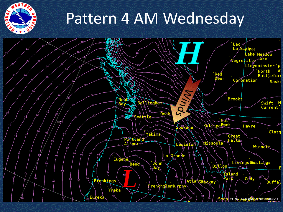
00z GFS forecast of MSLP valid 4 AM PST Wednesday, November 27th, 2019

Wednesday is when winds increase even further.  Thankfully, the storm over Oregon weakens, but the squeeze is on between high pressure to our north, and the Oregon storm to our south.   Note the tight packing of the pressure gradient.  The graphic above was from one model solution (GFS).  Other model solutions such as the European and Canadian show a similar depiction. 

With the strong northeast winds will come colder air, here are the forecast highs for Thanksgiving Day.

NWS Forecast issued Sunday morning of high temperatures Thanksgiving Day
And the cold will likely stick around for awhile.  Here are the 6-10 and 8-14 day temperature outlooks from the Climate Prediction Center.

CPC 6-10 day temperature outlook issued Nov 23rd valid Nov 29-Dec 3rd, 2019

CPC 8-14 day temperature outlook issued Nov 23rd valid Dec 1st-7th, 2019

Although currently the cold pattern looks like a dry one with latest CPC 6-10 outlook favoring drier than normal.

CPC 6-10 day precipitation outlook issued Nov 23rd valid Nov 29-Dec 3rd, 2019

But let's not forget what's bringing us the colder weather.  And that is strong northeast winds on Wednesday.  Those with Thanksgiving Eve travel plans should monitor the latest forecasts.  And if you are traveling to other states especially south or east, snow could impact your travel.  For the latest forecasts, watches, warnings, and advisories visit weather.gov or for local travel plans across Central and Eastern Washington and north Idaho weather.gov/spokane

Friday, November 15, 2019

The persistent ridge - A look back and forward

Curious what this winter will bring?  In past years we have written a blog about the winter outlook in late September or October, but this winter prediction has been a challenging one.  Let's begin with the weather pattern since last February.

500mb height anomalies for selected time periods since February 2019
 
Lots of colors to look at.  The screaming message has been the persistent ridge in the eastern Pacific.  It has had varying magnitudes and placement but has been there in some way, shape, or form since February.  Last February and March it was very amplified bringing cold and snowy weather to our region.

Over the summer the ridge allowed weather systems to drop down into the area with the # of 90 degree days much lower compared to the past five years.


And then this past October was noteworthy with the coldest October for many across the Inland NW.


Now it's November, and the very amplified ridge has given us a very dry start to the month as well as much of the western US.


It does look like a weather system will track into the area early next week (Nov 17-19th) time frame bringing rain and high mountain snow.  Here is the Nov 18th pattern showing a low off the WA/OR coast with the jet stream over the area.

12z Canadian model forecast of 500mb heights and 250mb winds (image) valid 4 PM PST Nov 18th, 2019

Don't expect this to be a long lasting change.  The ridge returns Wednesday and will probably last through the rest of the week.

12z Canadian model forecast of 500mb heights and 250mb winds (image) valid 4 PM PST Nov 20th, 2019

So the persistent ridge - what does it mean for this winter?  We are looking at a neutral year (neither El Nino or La Nina), which typically brings a lot of variability for our winter weather.  But on average, this is the pattern that sets up

Typical weather pattern for ENSO-Neutral years

Typically active weather sets up as a Pacific Jet Stream takes aim at the area.  With this said, it's interesting that several climate models want to give us a wet December.  Here is what the average of the models (NMME forecast) shows.

NMME model forecast of precipitation anomalies Dec 2019
But how much confidence can we have in this climate model projection?  Unfortunately, the skill score map is very low (want to see greens and purple over our area) meaning forecasting precipitation anomalies just one month into the future this time of year is hard for the models to depict accurately.

NMME skill score of precipitation anomalies initialized in November for December
So, what will this winter bring? Given the neutral winter a more active pattern setting up is a good possibility.  But when this occurs and how long it lasts carries low confidence given the tendency for high pressure over the eastern Pacific since last February.  As with any winter, short term significant winter events are likely.   Common winter hazards for the Inland NW include snow, ice, winds, and local flooding.