CPC reissued a La Nina Watch on October 13th. The watch stated a 70% chance of La Nina conditions this fall and a 55% chance for the winter. If a La Nina does develop its expected to be weak. We re-ran some maps and numbers this morning for weak La Nina years, which showed a similar story as neutral years with variability being the key piece. If a weak La Nina develops, near to below normal temperatures are favored while precipitation remains more uncertain. The same conclusion came about in this blog when looking at neutral years.
--------------------------------------------------------------------------------------------------------------------------
Now that fall is here, many might be wondering what kind of winter will occur this year. In this blog we'll take a look at this.
Typically each fall forecasters take a close look at the ENSO-state, whether we are expecting a El Nino, La Nina, or neither (which is considered neutral). Large scale weather patterns are influenced by what happens in the tropics.
For this season, the Climate Prediction Center is favoring neutral conditions or a weak La Nina. What does this mean for us? Here is a map showing typical patterns in neutral years.
 |
| Typical winter pattern during ENSO-Neutral years |
Neutral years tend to bring a wide variety of weather to the Inland NW. The Pacific Jet Stream brings storms into the west coast, but frequency and location vary. The polar jet stream tends to send cold air from Central Canada southeast across the upper midwest and northeast US. However this too can fluctuate.
October looks like it will finish much wetter than normal as an active Pacific Jet Stream takes aim at Washington, Oregon, and Northern California. Here is the latest CFS forecast with the green and blue colors over us indicating wetter than normal
 |
| CFS forecast for precipitation anomaly October 2016 |
Let's dig a little deeper for Neutral years. Here is map that averages all Neutral years during the winter months for temperature and precipitation. What does it look like?

This shows temperatures slightly cooler than normal and precipitation close to normal for the Inland Northwest. What this doesn't show in the variability that occurs and that every neutral year is different. Want to see this for yourself? OK, let's start with temperature

Since 1980, there have been 14 neutral years. As you can see, a lot of variability...
6 - cool
5 - normal
3 - warm
What about precipitation? Same story

5 - dry
6 - normal
3 - wet
The 1950-1979 years (not shown) were also analyzed which showed a similar story. When looking at 1950-2015 period of record, temperatures ended up near to cooler than normal most frequently (20 out of 28 cases), while precipitation showed no clear signal. A warmer and drier than normal winter has never occurred in a neutral year. If a weak La Nina develops this winter, this would also support a near to cooler than normal winter.
What about snowfall? Let's look at four locations:

As you can see, variability is the rule especially for Spokane and Wenatchee. In general, the 1996-1997 winter was a snowy one especially in Bonners Ferry where over 160 inches fell. The 1992-1993 winter was also snowy. Meanwhile, the 1980-81, 1993-94 winters brought much less snowfall.
So now that we have looked at history of neutral years, let's see what the outlooks from the Climate Prediction Center issued in September are suggesting.
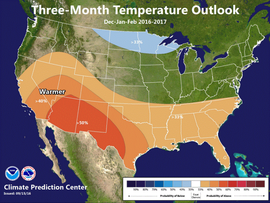 |
| CPC Dec-Jan-Feb temperature outlook issued Sept 15th, 2016 |
 |
| CPC Dec-Jan-Feb precipitation outlook issued Sept 15th, 2016 |
These forecasts show a similar story. For temperature forecast is for EC (Equal chances), meaning there is no clear signal whether this winter will end up cooler than normal, normal, or warmer than normal. For precipitation, wetter than normal is just slightly favored.
Regardless of how this winter shapes up in the long haul, the Inland NW always gets impacted by winter storms bringing wind, rain, snow, and even occasional pockets of freezing rain. Don't be surprised by an arctic blast. So be prepared for these storms before they arrive by keeping informed of latest weather forecasts.