With another La Nina winter in store, many are probably wondering what flavor this version will bring. Let's begin with the typical La Nina pattern that sets up.
 |
| Typical La Nina Pattern |
In past La Nina winters, we often go into a northwest flow pattern bringing wetter than normal, and at times cooler than normal conditions. But the key word in the graphic above Polar Jet Stream is variable. The jet stream rarely stays in this configuration throughout the entire winter as there are other factors that can alter the jet stream.
What is the current state of La Nina? Sea Surface Temperatures (SST) have been on the decline in the central and eastern Equatorial Pacific with La Nina conditions already present.
 |
| Average SST (Sea Surface Temperature) anomalies Oct 3rd-Oct 30th, 2021 |
The probabilities of La Nina conditions remain high through the winter as noted by the blue (La Nina) probabilities for each 3 month season (DJF is December-January-February).

As you'll see with some charts that follow, snowfall varies for La Nina winters. But if we average all the La Nina Winters together between 1950-2015, snowfall is typically above normal across the region as the map below shows.
 |
| % of normal snowfall for La Nina winters between 1950-2015 when compared to all other winters |
The map above is interactive and can be found here. Each site is clickable and will bring up a comparison chart for El Nino, La Nina, and Neutral years.
As some of you may know we are heading into the second of consecutive La Nina winters. So what did the second La Nina winter bring in terms of snow for Spokane for previous cases? As you'll see, 9 out of 10 brought normal or above normal snow.
 |
| Observed Spokane snowfall for the 2nd of consecutive La Nina winters |
What is the Climate Prediction Center outlooks showing? They favor elevated odds of cooler and wetter than normal conditions.
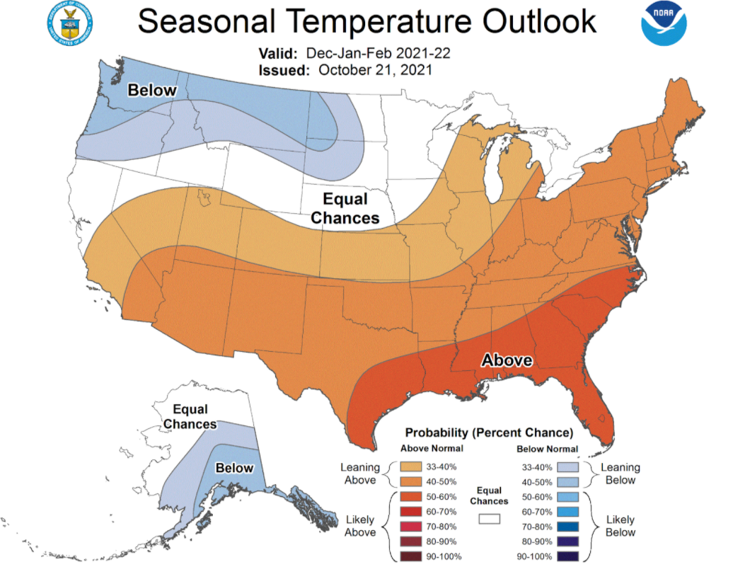 |
| The Climate Prediction Center Seasonal Temperature Outlook valid Dec 2021-Feb 2022. Issued October 21st, 2021. |
 |
| The Climate Prediction Center Seasonal Precipitation Outlook valid Dec 2021-Feb 2022. Issued October 21st, 2021. |
How about the climate model projections? The NMME (North American Multi-Model Ensemble) is favoring normal temperatures and above normal precipitation for the region.
 |
| NMME (North American Multi-Model Ensemble) forecast of temperature and precipitation December 2021-February 2022. |
So at this point odds are tilted towards the cooler and wetter than normal conditions.
This outlook is good news for the ongoing drought across the region. While there have already been some improvements with the drought situation, we need more precipitation. Here is the U.S. Drought Monitor as of November 2nd showing severe to exceptional drought still over most of the region.
 |
| US Drought Monitor as of November 2nd, 2021 |
The wetter than normal winter that is favored should bring continued improvements with the latest outlook showing this.
 |
| US Seasonal Drought Outlook valid Oct 21st, 2021-Janueary 31st, 2022. |
One important thing to keep in mind is we are talking about winter conditions averaged over a three month season. There are several shorter term weather events that can create a multitude of weather hazards. This includes freezing rain, blowing snow, local flooding, windstorms, and heavy snow events. Periods of quiet weather typically occur as well. Are you ready for winter? Now is the time to get ready.