Sunday, December 31, 2017

Top Weather Events of 2017


As 2017 comes to a close, let's take a look at the weather of the past calendar year. The year began with a cold and snowy January. Then, spring was marred by flooding and landslides. Our summer featured long periods of dry weather with many smoky days during August and September. The fall was relatively quiet followed by a couple of big winter storms during the second half of December.

This chronological list takes a look at ten or the Inland Northwest's top weather events of 2017.


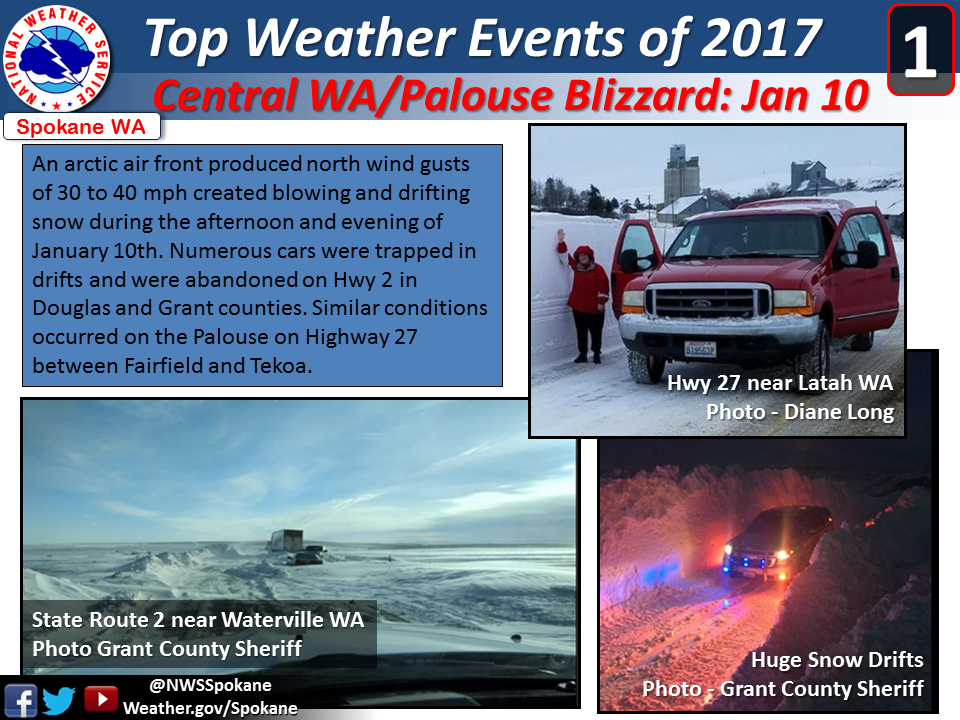
#1. The Central Washington and Palouse Blizzard of Jan 10, 2017 is the first on our list. Drifting snow closed several highways and left cars stranded over portions of Douglas and Grant counties.


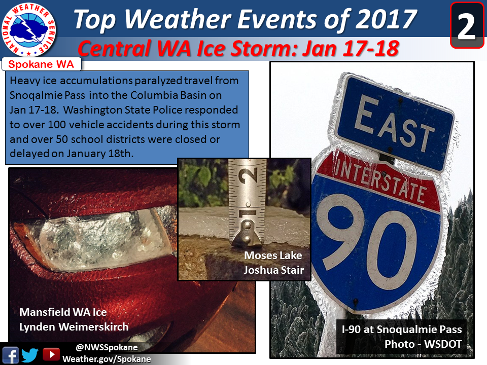
#2. The Central Washington Ice Storm: January 17-18. Freezing rain coated the I-90 corridor from Snoqualmie Pass to east of Moses Lake with more than a half inch of ice.


#3. February Ice Jam Flooding. The St Joe River, the Grand Ronde River, and several other creeks and streams in Spokane and Shoshone counties experienced ice jam flooding. Arctic cold in January gave way to heavy rains in February. The subsequent ice jams caused flooding and threatened to damage bridges in southeast Washington and the southern Idaho Panhandle.


#4. March Flooding. Above average rain on top of a deep snowpack pushed many rivers in Idaho and Washington above flood stage. Sprague Washington experienced weeks of high water as the creek entering town flooded fields and streets.


#5. April Landslides. Record amounts of precipitation over the winter combined with the release of frost in our soils caused landslides over the steep terrain of Washington and Idaho.


#6. Number 6 on our list of Top Ten Weather Events of 2017 actually features a day of beautiful weather. During a summer plagued by wildfire smoke and grey skies, eastern Washington and north Idaho enjoyed perfect conditions for viewing the solar eclipse.


#7. Camas Prairie Thunderstorm Wind. Residents of the southern Idaho Panhandle will likely remember number 7 on our list of Top Weather Events of 2017.  Back to back days of damaging thunderstorm winds hit the Camas Prairie on August 29 - 30. Trees were damaged and lightning sparked wildfires.


#8. September Smoke. Number 8 on our list of Top Weather Events of 2017 is a period of weather many of us would like to forget...the wildfire smoke. Cough!  Smoke flooded the Inland Northwest on Labor Day and lingered for the next 4 or 5 days. Spokane experienced some of the worst air quality on record during the first week of September. 


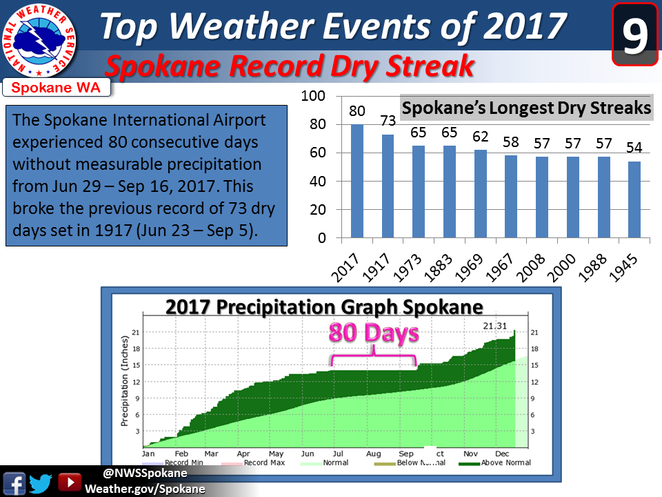
#9. Spokane Record Dry Streak. Our winter and spring featured record amounts of precipitation. Mother Nature did an about face during the summer. From June 29th through September 16th, the Spokane International Airport received no measurable precipitation. 80 consecutive dry days...a new record. 


#10. Heavy Wet Snow: December 19th. A big dump of heavy wet snow rounds out or list of Top Weather Events of 2017. For residents of Sandpoint, Bonners Ferry, and Naples, this storm is still fresh in your memory.  Bonner, Boundary, and Pend Oreille counties receive a foot of heavy wet snow.


Saturday, December 23, 2017

Christmas Eve/Christmas Day snow update

For those hoping for more snow by Christmas morning, we have good news for you.   Are you traveling on Christmas Eve?  When will the snow start?   And how much will it snow?  Let's get started!

TODAY (SATURDAY):

For today (12/23) we are under a dry northerly flow ushering in colder air to the region.  The next system is approaching off the coast as shown below

12z/23rd GFS model forecast of 500mb heights and 700-500mb Relative
Humidity valid 21z (1 PM PST) this afternoon (12/23)

TOMORROW  (CHRISTMAS EVE):

The offshore system begins to spread clouds into the Cascades tomorrow morning as shown below before precipitation begins to spread east in the afternoon and evening.

12z/23rd GFS model forecast of 500mb heights and 700-500mb Relative 
Humidity valid 18z (10 AM PST) Sunday (Christmas Eve)
MONDAY  (CHRISTMAS):

Light snow Monday morning will become focused mainly across SE Washington into North Central Idaho Christmas afternoon.

12z/23rd GFS model forecast of 500mb heights and 700-500mb Relative 
Humidity valid 21z (1 PM PST) Monday (Christmas)

So, have travel plans for Christmas Eve or Christmas Day?  Let's take a closer look at our forecast of snow amounts each 6 hours to get a better idea of when snow will start, and then end.

Sunday (Christmas Eve) Snow amount

4 AM-10 AM

Dry conditions across Central and Eastern Washington into north Idaho.

10 AM-4 PM

Snow spreads into the Cascades and much of Central Washington Sunday afternoon.

4 PM-10 PM

Snow continues to spread northeast, reaching the Spokane/Coeur d'Alene area Sunday evening but with the higher snow intensities around Wenatchee, Yakima, Tri-Cities, and Lewiston.

Christmas Day snow amount

10 PM Christmas Eve - 4 AM Christmas 

Snow over nearly all of the area, except possibly near the Canadian border.  Highest snow intensities over the Palouse, Lewiston-Clarkston Valley, Blue Mountains, and Camas Prairie.

4 AM - 10 AM 

Snow begins to decrease Christmas morning, but still a chance of light snow over most areas.  Steady accumulating snow continues over SE Washington into North Central Idaho.

10 AM - 4 PM

Dry conditions over most of Central, NE Washington, and into the north Idaho Panhandle during Christmas afternoon.

So, how much are we expecting?  Here is our forecast as of 2 PM December 23rd.


The previous blog discussed model uncertainty leading to lower confidence in snow amounts.  Models have come into better agreement, although the European model would support slightly lower amounts than what our current forecast shows.   Snow amounts will continue to be updated as this event evolves.  Please see our web site for the latest forecasts, and winter weather highlights found here

Thursday, December 21, 2017

More snow by Christmas?

Are you hoping for a White Christmas this year?   Is more snow on the way?  We'll examine this further in this blog, so lets get started.

When talking White Christmas, it's always good to see who has snow, and who doesn't.  Here is this morning's modeled analysis...

NOHRSC modeled SWE (Snow Water Equivalent) valid 17z (9 AM PST) Dec 21st, 2017

As of today (Dec 21), areas along the East Slopes of the Cascades, northern valleys, and into the Idaho Panhandle had snow on the ground while across much of the Columbia Basin, Spokane area, Palouse, and Lewiston-Clarkston Valley snow cover was spotty or non-existent.  The weather pattern ahead will be cold and thus areas with snow on the ground now look good for a White Christmas.

But what about more snow opportunities you ask?  There will be two more opportunities.  The first arrives tonight into Friday with the bulk of the moisture hitting the Idaho Panhandle, Blue Mountains, Palouse, the Lewiston-Clarkston Valley, and the southern Columbia Basin.  Here is our forecast snowfall as of 2 PM today.

NWS snowfall forecast issued 2 PM Thursday, valid through Friday

Cold and dry weather is expected Saturday, before the next system arrives Sunday (Christmas Eve).
Here is one model solution (GFS) showing an increase in moisture moving across the area on Sunday.

12z/21st GFS model run of 500mb heights & 700-500 mb Relative Humidity valid 18z Sunday (10 am PST)

This solution would bring widespread light to moderate snow accumulations for all of Central and Eastern Washington into North Idaho giving all areas a White Christmas.  However as of this writing quite a bit of uncertainty remained with how much this system will hold together as it passes through.  A different model (European) takes the system further south mainly into Oregon, clipping southern Washington and the Lewiston-Clarkston Valley.

To further convey the uncertainty, ensemble forecasts can be used which is a set of forecasts run with slightly different initial conditions to see what range of outcomes exist.  Here is one ensemble forecast (GEFS) showing snow accumulations for Spokane.

EMC's GEFS plumes for snow at KGEG (Spokane Airport) from 12z/21st December run
This shows most solutions giving Spokane a dusting of snow early on the 22nd (Friday), followed by a second and more significant round of snow on the 24th (Christmas Eve) possibly extending into early Christmas Day.  But note the spread in amounts.  The solid black line is the average which shows about 2 inches, with most members in the 1 to 2.5 inches range.  Stay tuned to the latest forecasts on our web site found here

In general, a combination of snow on the ground now in some areas combined with the potential for more snow Friday and again Christmas Eve should give most locations a White Christmas this year.