Monday, November 2, 2020

La Nina - Does this mean a harsh 2020-21 winter?

After high winds and even snow already hitting parts of the region in October, many may be wondering what this winter will bring.  In this blog we dive into the Winter 2020-21 outlook, so lets get to it.

Some of you may have already heard about the upcoming La Nina winter.  What does this mean for the Inland NW?  Let’s take a look at the general pattern that often sets up during a La Nina.


Typical La Nina pattern


Typically the jet stream enters into the region from the northwest bringing in cooler temperatures and precipitation.  This is a good combination for snow lovers, with just about all locations historically receiving above normal snowfall.  But not every La Nina brings above normal snow! Here is a locally developed map showing percent of normal snowfall for all La Nina years from 1950-2015 based on historical snow data for all our COOP sites as well as airports.


% of normal snow La Nina years 1950-2015


This map is interactive, link here. Snow charts are available like the one below for all sites on the map by either clicking on the number icon on the map, or by selecting a city to the right of the map.


Spokane snowfall (inches) based on ENSO.  Red line is average snow for all years 1950-2015 


It is worth noting however that every La Nina is different, as shown by snow totals for all La Nina winters in Spokane since 1950


Spokane snowfall for each La Nina year since 1950


The reason for the difference is another oscillations in the atmosphere that impact our weather during a winter.  La Nina is only one piece of the puzzle.


So what will this La Nina bring?  Let’s take a look at the Sea Surface temperature anomalies in the Central and Eastern Equatorial Pacific from Oct 4-31st, 2020.


Wow, that is a lot of blue in the equatorial Pacific!  A large area of cooler than normal waters which continues to cool with time.  Anything colder than -1.5C that persists for a duration of three months or more in the central and eastern Equatorial Pacific (Nino 3.4 region) would be classified as a strong La Nina. 


This particular model has a good handle on the current anomalies, suggesting a strong La Nina this winter with the cold anomalies bottoming out near -2.0C.  Each line in the image is one ensemble member forecast amongst the same model.

CFS Model of Nino 3.4 SST anomalies

Past strong La Nina years


We thought it would be interesting to look back and previous Strong La Nina episodes to see what happened.  Here we will look at 3 of the past 4 events.

2010-11


The last strong La Nina year was 2010-11.  This was a harsh winter in terms of several cold air outbreaks.  Republic had four episodes where lows dropped below 0F, with the coldest low -14F. The blue bars on this graph are the observed temperatures for each day.


Republic temperatures Oct 2010-Mar 2011

Similar story for Pullman, with temps as low as -12F that winter


Pullman temperatures Oct 2010-Mar 2011

2007-08


Lots and lots of snow this winter.  Spokane had 92.6” for the season with January and February bringing frequent rounds of it along with drifting snow like this image from NWS Spokane on Feb 7th, 2008.


NWS Spokane February 7th, 2008

And Sandpoint an impressive 122.8”!


Sandpoint accumulated snowfall Oct 2007-Apr 2008


1998-99


This La Nina winter broke records in terms of mountain snow.  A very active jet stream brought frequent rounds of heavy mountain snow.  The map below shows horizontal wind speed anomalies for the winter with the enhanced jet stream aimed at the region


Observed zonal wind anomaly Nov 1, 1998 - Feb 28, 1999


Mount Baker in the Northern Cascades of Washington measured 1,140”, claiming this to be a world record!


Mt Baker snow totals with the 1998-99 noted as a world record

But the strong influx of milder air off the Pacific didn’t mean a snowy winter for many of the lower elevations.   Here is a temperature graph from Moses Lake (brown shade is the normal range while the blue bars are observed).  You can see temperatures were above normal for much of the winter, except for one cold spell just before Christmas.


Moses Lake temperatures Oct 1, 1998 - Feb 28, 1999

2020-21?


So what about this winter?  Lots of possibilities based on some of the recent strong La Nina years.  Here are the latest CPC outlooks.


CPC Dec 2020 - Feb 2021 Temperature Outlook issued Oct 15th, 2020

CPC Dec 2020 - Feb 2021 Precipitation Outlook issued Oct 15th, 2020

These outlooks suggests slightly elevated odds of cooler and wetter than normal conditions.


What are the climate models suggesting?  An active Pacific jet with above normal precipitation as noted by the green shading on the second image, and about normal or slightly above normal temperatures.


NMME forecast of temperature anomaly Dec 2020 - Feb 2021

NMME forecast of precipitation anomaly Dec 2020 - Feb 2021

It is worth noting though that the climate models can often capture the details of La Nina well, but often miss other less predictable factors that vary on the time scale of weeks. 


So what flavor of winter will this La Nina bring? La Nina winters historically bring above normal snowfall, so be prepared for an active winter.


Thursday, September 3, 2020

Labor Day Weekend - Heat, wind, elevated fire concerns, and potential dust

Have plans for the Labor Day Weekend?  We have heat, potentially critical fire weather concerns as well as blowing dust to discuss.

First let's talk about the dry conditions.  The Inland NW has been very dry since July 1st as noted by this graphic.

% of normal precipitation July-August 2020

Central Washington has been bone dry.  The NE Washington Mountains and the Idaho Panhandle has received only about half of normal precipitation.  That said, the fire danger class rating from Sept 2nd indicated high to very high very danger across much of the western US including Central and Eastern Washington and north Idaho.


Thankfully, despite the high fire danger, most of the current large fires are south of our region with air quality not looking too bad.   The exception is the Evans Canyon Fire near Naches, WA which has been producing a continuous feed of smoke the past few days and occasionally impacting air quality in some areas.  Part of the reason for the lack of fires in Washington so far is below normal lightning where NWCC (Northwest Interagency Coordination Center) has reported only 30% of normal lightning strikes for Washington and Oregon combined from June through August. 

Air Quality readings at 12 PM PDT Sept 3rd, 2020

For the current version of this map, click here

So what about the Labor Day Weekend?  Strong high pressure over the western US (as shown below) will deliver temperatures well above normal, with Friday likely one of the hottest days.

GEFS 500mb heights and anomlies valid 11 AM PDT Friday, Sept 4th, 2020

In fact, records may be in jeopardy at some locations.  Here is a look at our forecast for Friday compared to records for the day.


Now, look at the change by the end of the Labor Day Weekend.  Dust and fire concerns will increase significantly.  Saturday and Sunday locally breezy winds will occur near the Cascades.  On Monday strong high pressure shifts west off the coast, allowing a cold front to drop in from the north.

GEFS 500mb heights and anomlies valid 11 AM PDT Monday, Sept 7th, 2020


The combination of increased winds and dry conditions will further increase fire danger.  A summary of fire concerns is listed below along with burn ban information


Here is a clickable version of the burn restriction links from above graphic


Here is one model depiction for Monday showing windy conditions over much of the region out of the north to northeast.  The numbers depict free air wind speeds near 5000 feet MSL and a general representation of wind gust potential.  This pattern typical favors the Okanogan Valley, Columbia Basin, and the North Idaho Panhandle from Sandpoint down to Coeur d'Alene with the windiest conditions.

GFS 850mb winds and heights valid 11 AM PDT Monday, Sept 7th, 2020

These winds combined with low relative humidity will elevate concerns for rapid fire spread with any new fire starts.  The winds may also bring choppy water on area lakes.

Blowing dust is also a concern due to several freshly plowed fields across the Columbia Basin and Waterville Plateau.  Soil moisture is very dry over the region especially Central WA and across the Columbia Basin with little to rain over the past 60 days

Total precipitation July 5th-Sept 2nd, 2020.  Blue numbers on map are observed values from area weather stations.


To summarize, heat will initially be the main concern with record highs possible Friday in some areas.  Focus then shifts towards blowing dust, increased fire danger, and rough lakes by Labor Day.  


Have a fun and safe Labor Day weekend!


Sunday, April 12, 2020

I-90 Dust and Dry Spring

Dry and windy conditions on Saturday led to blowing dust on I-90 between Moses Lake and Ritzville, which contributed to a seven car pile up accident at MP200.  East bound lanes were closed, along with 1 west bound lane for about an hour.  Here is a picture courtesy of WSDOT.

Blowing dust on Interstate 90 - Photo courtesy of WSDOT
 

The worst of the dust on I-90 was seen on satellite imagery from 2 to 4 pm.  We tweeted a satellite loop showing the dust tracking across I-90 from north to south east of Moses Lake.  To see the loop, please click here


NWS Spokane Twitter post at 4:04 PM April 11th, 2020
New GOES-17 Satellite imagery also picked up on the dust, as shown by the darker pink colors near Moses Lake.

GOES-17 Dust RGB 2 PM - 5 PM PDT April 11th, 2020

And a more zoomed in look


So, what were the winds doing during this time frame?  A WSDOT sensor from Warden is shown below.  Winds were sustained around 25 to 30 MPH with gusts up to 42 MPH.

Warden observations

Here is a broader view of peak wind gusts from April 11th

Peak wind gusts from April 11th


So what other factors led to the dust besides the dry and windy conditions?  For one, spring planting is ongoing with some freshly plowed fields.  Second, it has been very dry since the start of the water year across Central WA with many places only receiving about half of normal precipitation.  Even less for the Yakima Valley.


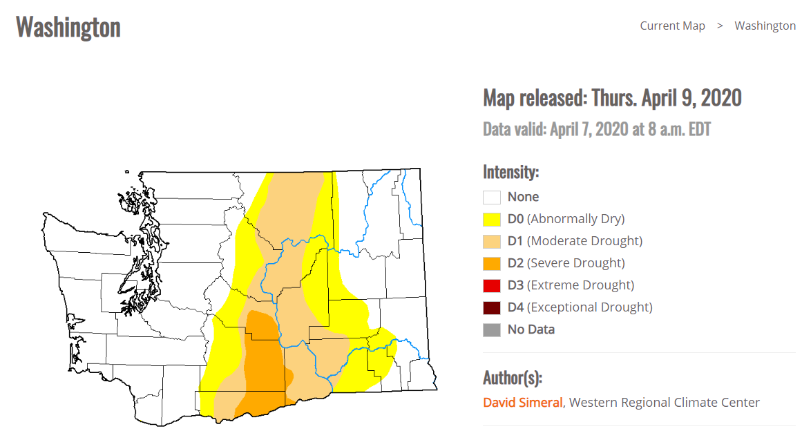
Moderate to locally severe drought is depicted in the latest US Drought Monitor

US Drought Monitor released April 9th, 2020

And while Central WA has been noticeably dry, it's worth noting that all of the region has been much drier than normal over the past 60 days.


What has caused this dry weather?  A large and persistent upper ridge in the Eastern Pacific.


The pattern this week looks similar, with a strong ridge off the coast providing more dry weather to most of the Inland NW. 

We will have to keep an eye out for more blowing dust potential across the Columbia Basin with any strong winds that develop given the dry soils and current Soil Moisture Ranking Percentiles.

Fortunately, at least for this week no strong winds are expected although breezy conditions are possible Tuesday night into Wednesday, but not as strong as what occurred on April 11th.  Also with the dry weather fire danger is above normal for the time being so pay extra attention to any burn restrictions for your area.


Monday, March 23, 2020

A worsening drought over parts of eastern Washington?

   Springtime across portions of the Inland Northwest has been very dry at least compared to climatology. We can measure just how dry using various tools in our meteorological tool box. One of the conventional tools we use is simply looking at precipitation maps across the region. So how have things looked over the past 90 days? 


As you can see things are highly variable across the region. near the Cascades it has actually been quite wet, with precipitation amounts nearly twice the average amount over the past 90 days. Also near the Washington/Idaho border amounts have been close to normal (aside from the southern Palouse, LC Valley, and Blue Mountains). However one area that  stands out is a portion of central Washington in the lee of the Cascades stretching from Omak down to Moses Lake and The Tri-Cities and Yakima areas. Some of these locations have seen only a quarter of the normal precipitation during this period. 

If we add the November precipitation amounts to the mix, the resulting map doesn't look much different for the dry areas. 

So that got us thinking is this a record of some sort? Now granted these statistics are rather arbitrary, After all, who calculates records from 11/23 through 3/21? Not many people, but just for fun we will examine some of these odd records. First we will look at Yakima. 

Yakima, WA precipitation 11/23-3/21
So in fact this is a top 10 driest period for Yakima, but it was actually drier in 2018. Now how about Omak? Not quite top 10 but close. 


And finally lets look at the Ephrata:

Only in 16th place out of the last 70 years and the driest since 2014. So although this is noteworthy, it isn't really a historic dry spell. 

But precipitation alone does not tell the entire story about a dry spell of weather. Other things to take into consideration during this period include; winds, temperatures, relative humidity levels, and solar radiation. All of these parameters will impact the amount of evaporation or evapotranspiration that can take place and how quickly the soils will dry out. That is a lot of information to keep track of, however fortunately we have a relatively new and very useful tool called the  Evaporative Demand Drought Index or EDDI. This takes all the aforementioned parameters into account and states how thirsty the atmosphere is. So what is this index showing for the area? If we go back to November things look particularly bad:
Over the entire Lower 48, no area has seen  more widespread and harsh drying conditions compared to normal. The categories on the map correspond to our typical drought outlooks. In this case the shading over eastern Washington corresponds to an ED4 or an exceptional drought. Does that mean this area is now in an exceptional drought? Not necessarily. A drought is not built on four months of weather alone, but if these trends continue we will certainly be faced with worsening drought conditions over this portion of eastern Washington. Since November here is how the drought monitor has been evolving across Washington.

These images start in the middle of November and advance two weeks at a time. The last image shows the drought conditions as of the middle of March.


Specifically looking at the March 17th the outlook:


This map shows that almost 23% of Washington is in a D1 or moderate drought which just so happens to correspond closely to the first precipitation maps we showed. But what is interesting is the EDDI maps show worse conditions than what's depicted by official drought maps and sometimes this can foretell the trends. EDDI itself is not a drought prediction, but at short timescales (such as what we have shown), it indicates the potential for drought (or trends). So this area certainly bears watching.


So looking past the EDDI values what do the longer range weather forecasts tell us? That is always a tough question to answer, but lets look. The 8-14 day outlook through the beginning of April calls for near normal precipitation and cooler than normal temperatures. Near normal precipitation amounts would certainly help. The cooler than normal readings should also temper the thirstiness of the atmosphere however that could be overcome by having unusually dry air masses in place or prolonged windy conditions.


As for the April outlook, things don't look terrific for a dramatic improvement at this point with below normal precipitation favored at this time with an equal chance of normal temperatures.


And finally, if we want to peer even farther into the future (April-June) the prognostication right now would suggest worsening drought conditions. But we will just have to wait and see.


So what are the ramifications of a drought over the Columbia Basin? While much of the area is irrigated for agriculture, there are areas which also have a considerable amount of sagebrush which could eventually lead to quick burning fires this spring. It could also lead to more blowing dust than normal on a windy day.  Part of this dry area also encompasses some denser fuels both east and west of Omak. Right now the nearest snotels (snow measuring sensors) depict a snowpack around 65%. It's too early to say if this will lead to a busier than normal fire season in these areas as we have found the leading cause of a big fire season is a hot and dry summer.

We will revisit this topic later this Spring to see how things panned out.


Thursday, February 13, 2020

Forecast Consistency (or lack thereof) for this weekend's winter storm

  You may have heard by now that a winter storm is coming to the Inland Northwest this weekend. While that is still true we are still trying to wrestle with what's been a particularly troubling forecast? Why is this forecast so difficult compared to others we do in the winter? The biggest reason has to do with forecast consistency or in this case a substantial lack thereof. When doing forecasts beyond a couple days we meteorologists are highly dependent on using weather models for guidance. We have a plethora of models to choose from and picking the best one isn't always an easy task. In fact in the winter this often isn't easy. But whats making this forecast especially tough is the models are offering us a multiple of solutions or forecast scenarios and the consistency from run to run has been unusually poor. When we see good consistency with the models this makes forecasting easier. Below is a great example of good forecast consistency. This map shows a ridge of high pressure forecast over the Upper Midwest for this afternoon. Each frame represents a subsequent model run from the GFS starting from last Sunday and ending with the model run from this morning. Notice that although the center of the high pressure (blue H) moves slowly westward with each model run, the overall pattern does not change much. Even the positioning of the light snow (blue shading) near the eastern Great Lakes does not show a huge amount of variability. So if a forecaster were sitting on the forecast desk for the past couple days and was following this evolution they could be fairly confident in forecasting a dry over most of the Upper Midwest.

GFS Forecast consistency over the Upper Midwest for this afternoon (2/13). Courtesy of Tropical Tidbits
OK so that forecast was an easy one for a ridge that isn't over our region. How about over the Inland Northwest what's the story? Let take a look at the cold front we expect to pass over the region this afternoon and evening. Although there are no definitive highs or lows on the chart below over the Pacific Northwest, there is a fairly consistent pattern with the precipitation. Notice over the Cascades, snow was depicted by the last 8 GFS model runs as well as rain off the coast and over the western interior. Meanwhile over eastern Washington into north Idaho there has generally been a consistent band of rain and snow extending from southeast Washington and into the Idaho Panhandle. This is the band associated with the cold front. For winter weather, this is very good consistency. Even the transition from rain to snow right around Spokane has been consistent.

GFS Forecast Consistency for the Pacific Northwest cold front as of 10 pm Thursday (2/13). Courtesy Tropical Tidbits

Now lets get to the system that started this whole discussion, the one for the upcoming weekend. When we posted our graphic yesterday here is what was shown. Notice each run was showing a low (red L) but look at how much variation there is from run to run. We know that the heaviest precipitation will be associated with atmospheric forcing or lifting from the low, but in order to put that information into our forecasts we need to have a good idea where the low is going to move.  Confidence levels when dealing with this type of model to model variability result in a very low confidence forecast. 

GFS Forecast Consistency for the Pacific Northwest storm system for 4am Sunday (2/16) Courtesy Tropical Tidbits
So far we have only looked at consistency using an operational model. This is not the best way to forecast for a weather scenario that is several days out. We have better tools at our disposal called ensemble forecasts. So what is an ensemble forecast? An ensemble forecast is a set or cluster of forecasts that present the range of weather possibilities in the future. To create the ensemble forecasts, multiple model simulations are run, each with a slight variation in its initial conditions. These variations begin to increase over time (in other words we will see more variations in the model forecast 144 hours out in the future compared to 12 hours out). These variations represent the uncertainty in the forecast and suggest a range of possible weather outcomes. If ensemble runs show little variation during portions of the forecast, this would infer a high probability of outcome and a high confidence forecast. If there are large variations, this would represent a low confidence forecast. For more on ensemble forecasting check out this link.

So what do the ensembles show for this weekends storm? First lets look at the position of the low pressure center as forecast by the GEFS or Global Ensemble Forecast System. The image below shows the positioning of the low forecast by each ensemble member of the model (there are 21 of them) as well as the average in all the solutions (black isobars). The red numbers correspond to the depth of the low and its center for each ensemble member (posted in millibars) while the colors in the background show the differences in all the runs. The brighter the colors the more variability in the runs. So on the image below the greatest variability is over the north Cascades (light green shading). This was the latest run of the GEFS.  It still does not give us a great amount of confidence as there are low centers scattered around much of area from the north Cascades to northwest Montana. The mean of all these runs places a broad (albeit weak) low across much of the Inland Northwest into northwest Montana.


GEFS Low pressure centers for 4 am Sunday. Courtesy of Tropical Tidbits
How did previous eight runs of the GEFS look? Although they all show some semblance of a low, the strength, positioning, and timing are all over the place. And the variability from run to run is substantial. Typically ensemble runs and their means tend to subdue the run-to-run variability. This isn't what we like to see when faced with the possibility of a large winter storm in our future.
GEFS Low pressure centers for the past 8 runs starting with the 10 pm Sunday run (2/9). Courtesy of Tropical Tidbits

So far we have only looked at weather maps which show the general positioning of the highs, lows,  precipitation, etc. But the devil is in the details. What does this translate into tangible weather on the ground? Since snow is generally the crux of this forecast and in the thoughts of many people, we can actually look at this element over Spokane again utilizing the power of ensemble forecasting. So what does this show? Below is the answer. Each grey line represents one of the 21 ensemble members. Some of the members show as much as 7 inches of snow in Spokane, while others barely have an inch. The blue line represents the GFS run while the black line is the mean of all the models. So as you can see the answer is all over the place. It all depends on the eventual track of the low. If it moves to our north (we think this is most likely based on other models), we would likely expect to see amounts on the lower end of these possibilities, while if it moves right over Spokane or slightly south we would see amounts on the higher end of the spectrum.
GEFS Plumes for snow over Spokane for this weekend.


While we don't have a lot of confidence for valley locations such as Spokane, we have much higher confidence it will snow (heavy at times) over the mountains as they are less dependent on the track of the low and more dependent on orographical lifting of moisture over the mountains due to upslope winds. Based on pattern recognition and the most likely low track our greatest threats will be near the Cascades, Central Idaho Panhandle Mountains, Blue Mountains and Camas Prairie. But that is subject to change as the models continue to offer a plethora of solutions. All we can say for now, is standby and wait for our latest updates for this daunting forecast.