 |
| GFS 500mb heights, winds, and Humidity (green shading) valid 11am PDT Monday 10 Aug |
The low off the Washington coast will slowly creep south along the coast over the next couple of days. Remember, winds go counter-clockwise around low pressure in the Northern Hemisphere. That means to the east of the low, the wind blows from south to north. This "southerly" wind will bring moisture up from the sub-tropics. We've already seen our dew points rise over the past couple of days.
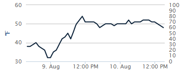 |
| Dew point at Spokane August 9 and 10 |
Note that the dew point has climbed from the mid 30s two days ago to around 50. That trend will continue for the next few days. So we will have moisture. The hot temperatures will provide the instability. That combination will produce thunderstorms. Here's a forecast of radar reflectivity from the HRRR model valid later this afternoon:

The HRRR expects thunderstorms from northeast Oregon and central Idaho to move into the Inland Northwest. Some of these could produce gusty winds and blowing dust.
While these storms could be strong, they are lacking one of the ingredients for a "big" event: lift. The low offshore is too far away to contribute much lift. And as it continues to drift south, it will be even farther away from us. So the storms for the next three days will have to rely on moisture and instability alone.
But on Thursday, that all changes. The low will begin to "eject" to the northeast. This is a common pattern. The tough part of the forecast is the exact track and timing of the low. Here's the current forecast from the GFS model:

Yes, it looks nearly identical to today. The difference is that at this point the low moving to the northeast. This is a classic pattern for severe weather in the Inland Northwest, and it's similar to some of the bigger events we had in 2014. That's not to say we're going to see a repeat of a 2014 event. But the potential is there for strong and widespread storms. Here's the NAM and GFS model forecasts of precipitation for the 5pm-11pm time frame Thursday evening.
 |
| NAM (upper) and GFS (lower) forecast of 500mb heights (thin lines) and precipitation (green shading) for 5-11pm PDT Thursday evening. |
First, you can see a difference in the predicted location of the low. The NAM has it over southwest Washington, while the GFS is slower with the low offshore still. But both models show convective precipitation over much of eastern Washington and the Idaho Panhandle. But the ECMWF (not shown) is even farther south with the position of the low, and so it has even less convection.
Here's the forecast CAPE (atmospheric instability) from the NAM and GFS:
 |
| NAM Forecast CAPE Thursday 2pm |
 |
| GFS Forecast CAPE Thursday 5pm |
Both models show plenty of instability, around 1500 J/kg, which is plenty for strong thunderstorms here. As you can see, the best instability looks like it will be over the northern and eastern mountains. Details like this could easily change over the next couple of days so stay tuned as we get a better idea of how this event will pan out. If the ECMWF is right, it could be a non-event, as the low would cross over us at night.
No comments:
Post a Comment