The Inland NW is currently heading into a strange weather pattern. There are several aspects that makes the upcoming pattern unusual, and odd. Let's start with a look at what is going on out there from 22,236 miles above the Earth's surface.
Below is Water Vapor Satellite Imagery, which is a measure of moisture in the atmosphere. Currently there are dark reds over Washington, most of Oregon, and north Idaho which means very little moisture out there.
 |
| GOES 18 Low Level Water Vapor Channel 230-520 PM PDT May 13th, 2023 |
Also of note is a low spinning over Nevada and Utah. That is so far away, typically not something we need to worry much about. More on that later.
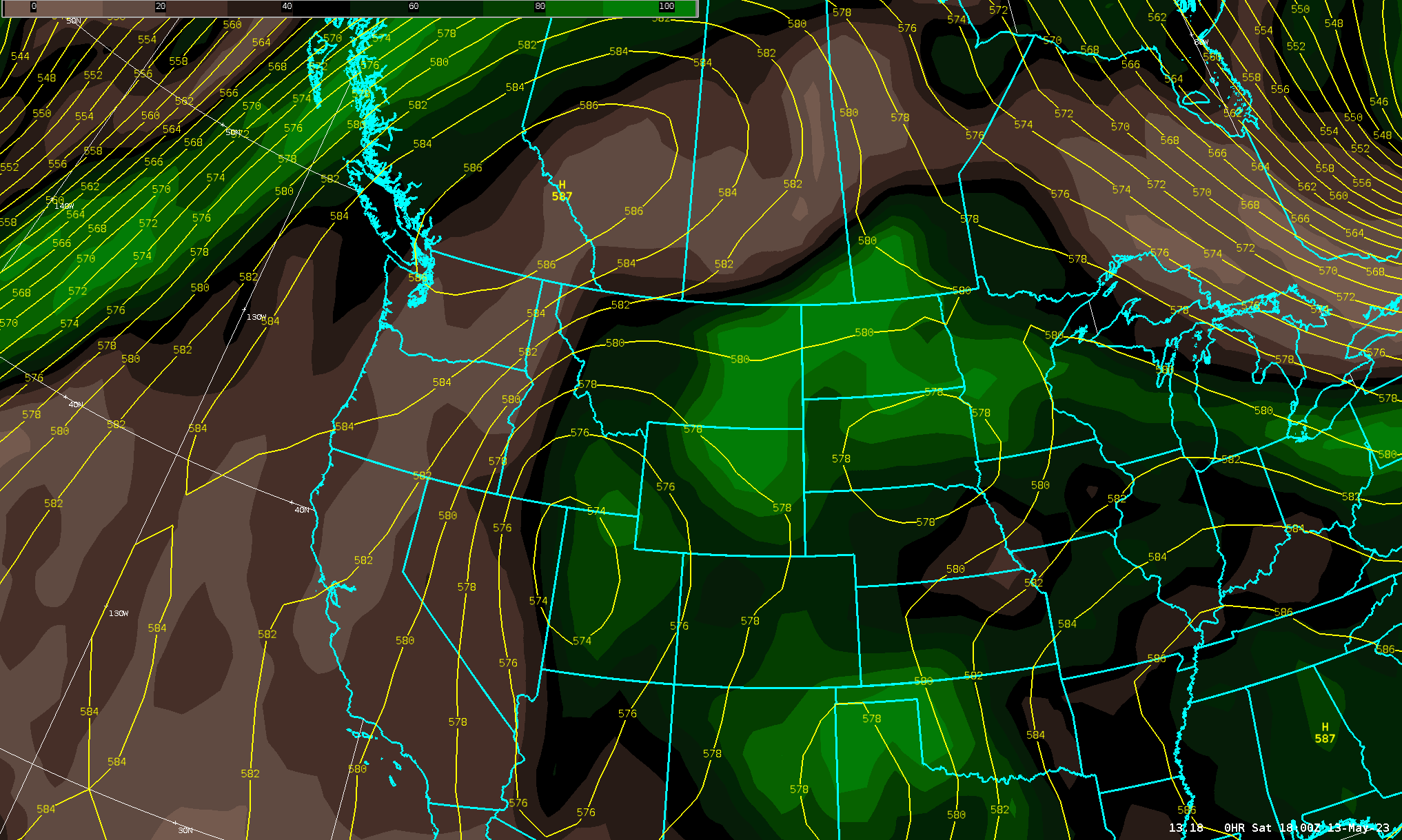
We now turn out attention to Canada. Why Canada? The forecast high pressure over the country is very noteworthy, and shown to be highly anomalous in the red shaded area. The graphic below compared the model forecasts to all other forecasts for this time of year from 2000-2019. Anything in red means the forecast is for something stronger than what has ever been forecast by the model in that 20 year period.
 |
| NAEFS Mean Geopotential Height (500 mb) and Return Interval. Dark Red means values fall outside those that have been forecast by the model between 2000-2019. |
In fact, the strength of the ridge will play a role in the track of the low over Utah and Nevada! We will get to that in few minutes, but let's take a quick detour to talk about what is going on in Canada. What is going on under this anomalous high pressure? Very warm temperatures which are aggravating wildfires in the country.
Here is today's wildfire map showing several active wildfires.
 |
| Map of current fires over western Canada and the Northwest US |
Here is a link to the above map. Orange fire icons means the fire is over 1,000 acres. Note most of the local fires are from prescribed burns.
Under this warm ridge, temperatures are abnormally warm in Canada with many areas in the upper 70s to mid 80s, which is comparable to many readings we are seeing locally.
 |
| Map of 5 PM Temperatures May 13th, 2023 |
 |
| 18z GFS forecast of 500mb heights and 700-500mb Relative Humidity through Friday, May 19th 2023. |
 |
| Precipitable Water Standardized Anomaly from 18z GFS Model valid May 14-19th, 2023 |
 |
| NBM (National Blend of Models) forecast of thunderstorm chances on 11 AM - 11 PM PDT Tuesday |
What are the main hazards from these storms? For that let's look at the forecast conditions of the atmosphere on Tuesday.
 |
| 18z GFS Forecast Sounding for Spokane, WA on Tuesday, May 16th at 5 PM PDT |
The red circled area has caught our attention. Winds are rather weak (15 MPH or less) through a very deep layer of the atmosphere. This means storms will be slow moving, and capable of producing brief very heavy rainfall, or flash flooding. Stay tuned for updates as this strange and odd weather pattern plays out in the coming days.
No comments:
Post a Comment